
Unlike Southwest Monsoon, which is a large scale global weather phenomenon, Northeast Monsoon owes a lot of its rainfall episodes to the presence of disturbances over Bay of Bengal or Arabian Sea. It becomes essential not only for the presence of these disturbances during the season but also at a favorable location in order to maximize the rainfall potential for Tamil Nadu and the rest of the Peninsular India which benefits from the winter monsoon. The downside to this disturbance driven rains are the heavy to very heavy rainfall episodes which happen time to time over the coastal areas of Tamil Nadu. In a way the heavy rainfall episodes which happens over Central India under the influence of the monsoon depression during SWM times happen on a smaller scale over coastal areas of Peninsular India.
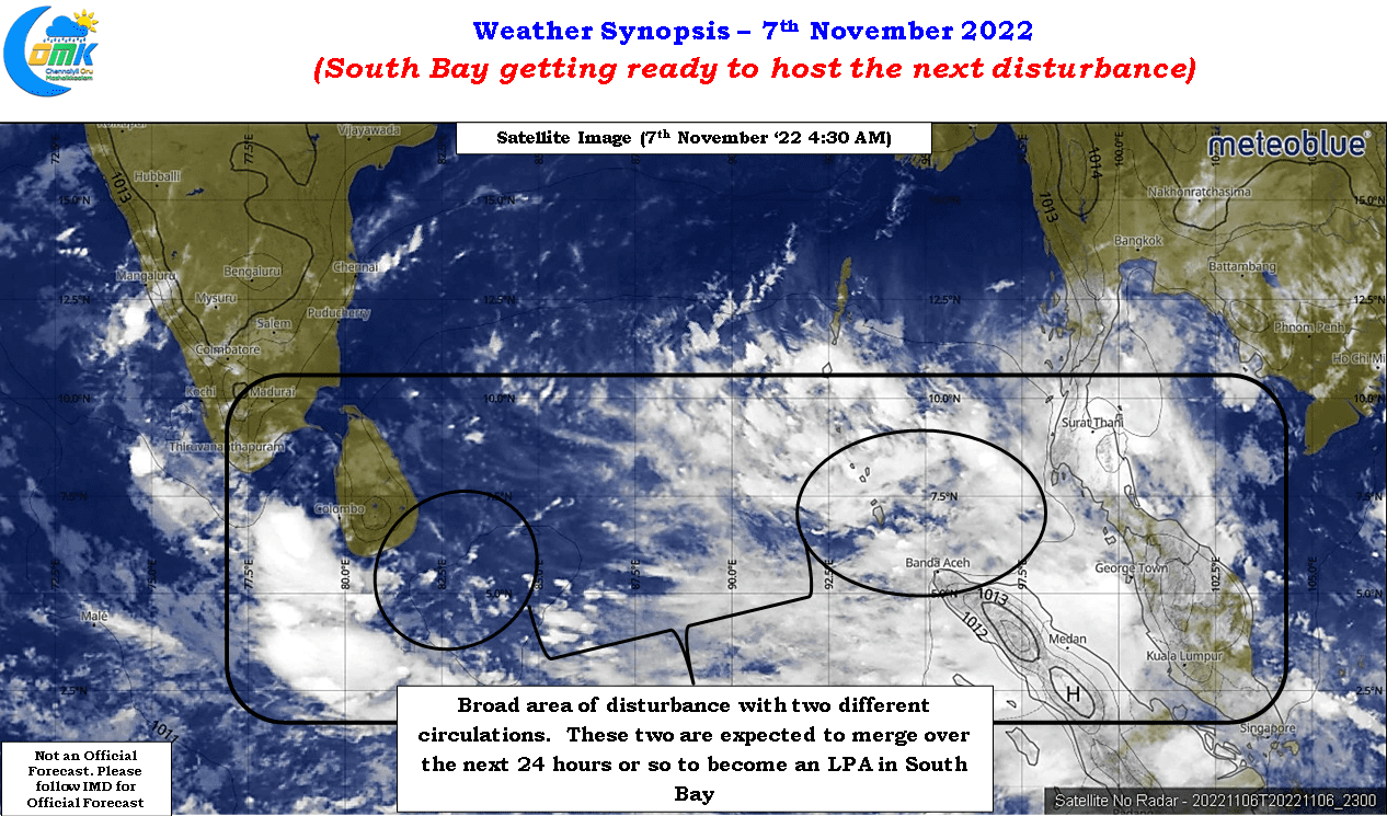
Weather models for the past week or so has been consistent about a possible disturbance developing into a Low Pressure Area over South Bay this week. The trough of low that brought about the first episodes of heavy to very heavy rainfall over Chennai and suburbs a week back last Monday has continued to persist in and around Sri Lanka giving rains to coastal areas of Tamil Nadu almost on a daily basis. One of the points we highlighted in our NEM 2022 outlook was the potential for a conveyor belt of pulses moving into Bay of Bengal from south China sea. While the trough of low continues to persist the next pulse has now moved into Equatorial Bay adjoining the Andaman Sea area. Weather models indicate the persisting trough of low could merge with the incoming pulse potentially developing into a Low Pressure area in the next 24 to 48 hours or so.
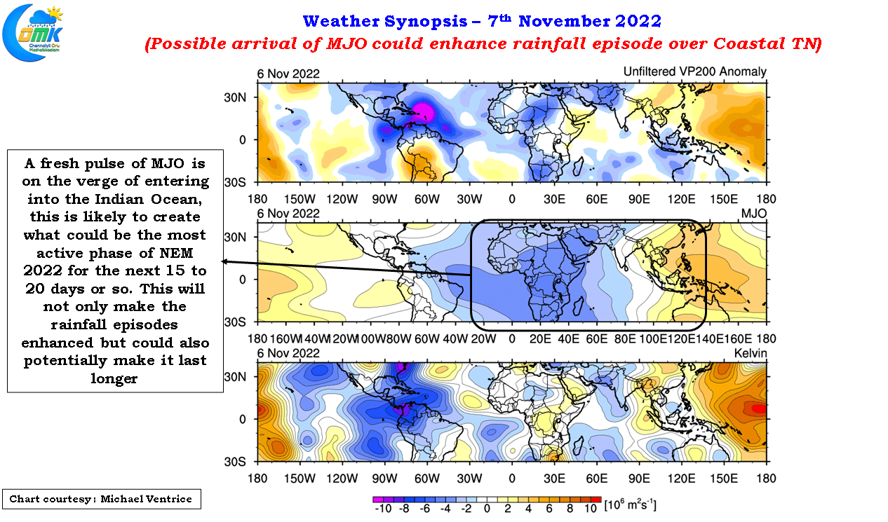
In this context it becomes essential to highlight another a very crucial development that is likely to make the next 15 to 20 days as possibly the most active phase of Northeast Monsoon 2022. A fresh pulse of MJO arriving from the west is on the verge of influencing the atmospheric dynamics over Indian Ocean. Irrespective of what happens to the MJO after it reaches the Maritime Continent during the second half of November the next couple of weeks is likely to be an active phase of NEM. The arrival of MJO is not only going to enhance the rainfall episodes but also make it persist longer than what medium and long term models expected say a couple of weeks back.

The direct impact on the arrival of MJO is a scenario ensembles are now picking in the form of the incoming pulse moving over Peninsular India and persisting as a circulation over the Arabian Sea. This creates a wide area of disturbance over Peninsular India bringing about recycling of moisture by the two circulations on either side providing for a platform for not only heavy rains over coastal areas of Tamil Nadu but also interior areas and potential very heavy rainfall episodes on the eastern slopes of the Ghats too.
In our post last Sunday we highlighted the potential for the urban clusters of Coastal TN including Chennai to maintain a vigil for possible episodes of heavy to very heavy rainfall under the influence of the trough of low. Weather models indicate the upcoming low also to move over the same area North of Sri Lanka which is likely to once again put the spotlights on the urban clusters over coastal TN. This could mean once again places like Chennai may come under an episode of rains which could potentially accumulate in excess of 20 cms over a couple of days.
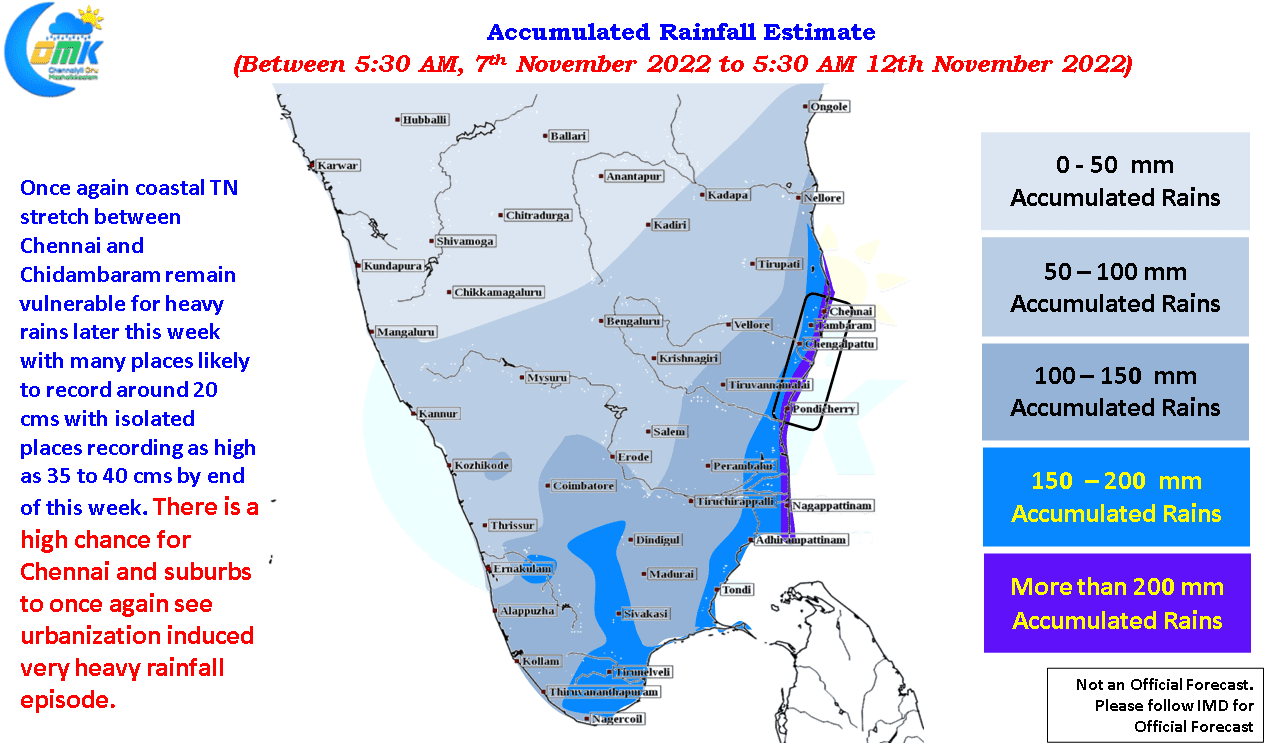
While the precipitation accumulation inference given as part of today’s post is an indication on what to expect a couple of pointers need to be kept in mind.
- There is a fair chance the actual precipitation accumulation may fall higher than the estimated precipitation accumulation for coastal areas.
- The precipitation pattern for interior areas to a great extent depend on the westward movement of the disturbance
- Though the precipitation chart is starting today up to 12th Nov. ’22 the heaviest spell of rains may happen between 10th & 12th of Nov. While the entire coastal stretch between Thoothukudi to Chennai could see heavy to very heavy rains in particular the stretch between Chidambaram and Chennai remains the most vulnerable in terms of rainfall intensity
- The Urban clusters of Coastal TN, including Chennai, is likely to see another burst of urbanization induced short duration high intensity rains during this episode of rainfall as well