
As we get to closer to the mid point of the Northeast Monsoon season, the seasonal rainfall tally for Tamil Nadu and Pondicherry subdivision stands at 234 mm against the long period average of 235 mm. The early part of the season saw some of the interior districts like Erode, Namakkal etc score heavily on account of transition thunderstorms and a delay in the monsoon dynamics establishing over the coastal areas. This period also coincided with the MJO transition over the eastern parts of Indian ocean enhancing transition thunderstorms. As October gave way to November things picked up along the coast greatly aided by the trough of low that stay put in and around Sri Lanka adjoining waters for most of the past 10 days giving widespread rains for Coastal TN.
This phase while supported by an ER wave coincided with a unfavorable MJO on account of it travelling slowly across west Pacific. Despite an unfavorable MJO the overall background dynamics provided enough support for NEM that Chennai and suburbs recorded 20 to 30 cms in two days time with some places even touching nearly 40 cms. Now with Bay all set to host a monsoon low there is support arriving from the “Kingmaker of Monsoons” right on cue. Real time observations indicate the influence of MJO is seen traversing west to east over Africa and in the next day or two will start moving across Indian Ocean.
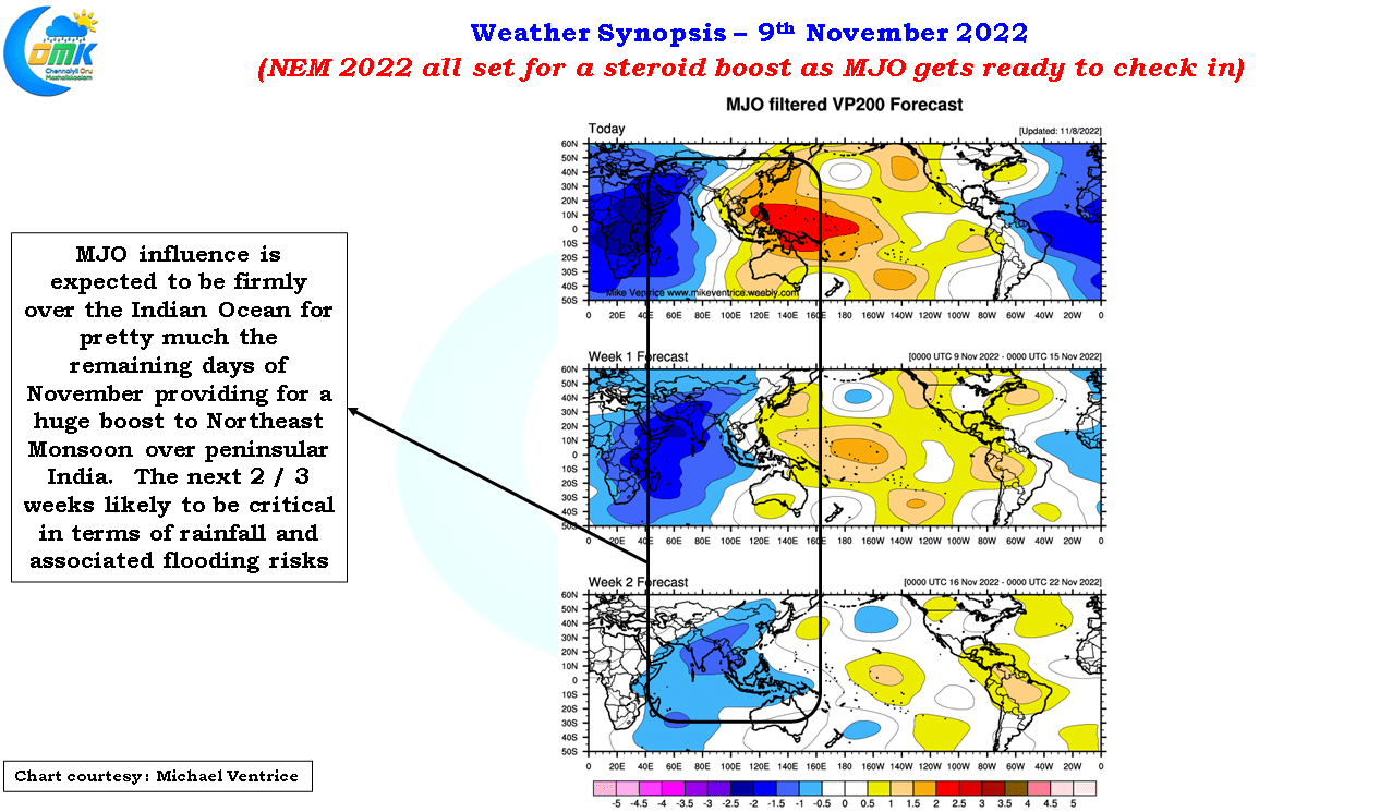
Weather models indicate as things stand for the next two weeks influence of MJO is likely to be over the Indian Ocean. 2021 NEM and also 2022 SWM to a great extent show to us the presence of MJO over maritime continent enhances monsoon dynamics as well in the form of regular pulses into Bay of Bengal from South China Sea. This scenario of a train of pulses running along the ITCZ all the way from Maritime Continent to peninsular India is now being picked up by not only long term models but medium term models as well. All this confirms “Northeast Monsoon 2022 is all set to take up power play” But as always it may make sense to take one week at a time and cross the bridge when it comes.
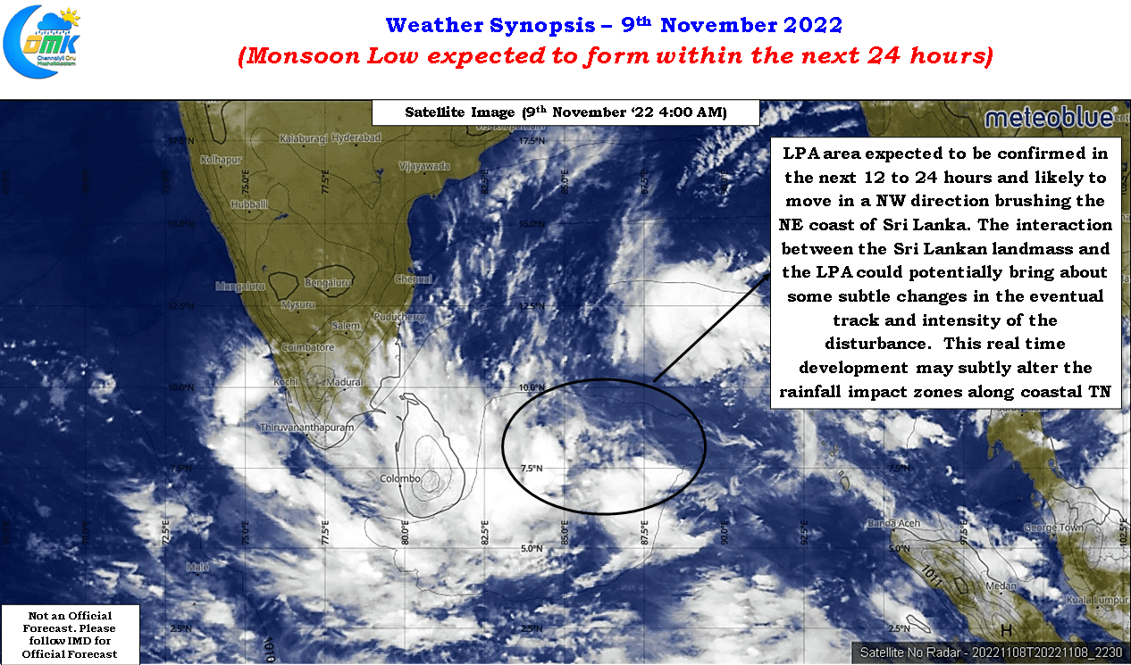
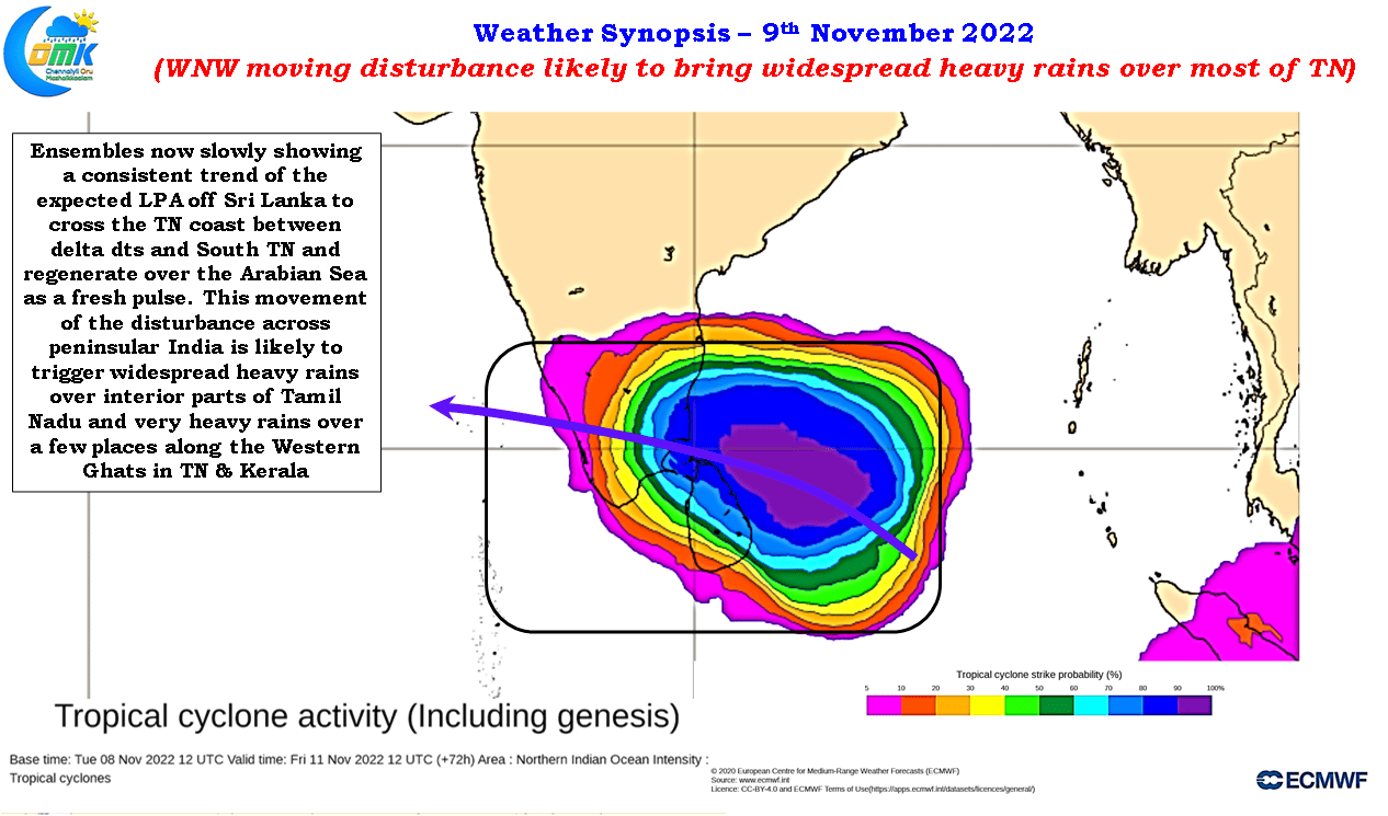
The upcoming low, expected to form in south bay within the next 12 to 24 hours, may be the first pulse of this MTC-South bay conveyor belt though one can argue the earlier trough of low also had its origins from a weak pulse moving west from Indo China Peninsula. Weather models are now fairly consistent about the LPA making a NW track brushing the coast of Sri Lanka over the next two days before moving in a WNW direction across peninsular India on its way toward emerging over the Arabian sea once again. While in principle the overall conditions prevailing is in sync with this there are a couple of factors that is likely to alter the dynamics slightly bringing about a subtle change in the impact zone and intensify of the rainfall episode. We wish to reiterate once again the entire coastal stretch of Tamil Nadu between Thoothukudi & Chennai remains vulnerable for heavy to very heavy rains over the weekend.
The LPA is expected to brush along the coast of Sri Lanka on its way towards the coast of Tamil Nadu. In the past we have seen this interaction throw up some complicated scenarios in the form of stalled circulation, changes in tracks etc bringing about extreme rainfall instances. The slight shift in WNW movement in tracks completely altered the dynamics as we can observe in the cases of Cyclone Nivar and Cyclone Burevi. This interaction with the Sri Lankan landmass needs to be closely watched in real time to identify potential heavy rainfall episode in unlikely locations. In addition to this land interaction there is another dynamic which has the potential to greatly enhance the flooding risk on account of persisting heavy rains over the same region.
A close observation of the mid level winds indicate this disturbance is expected to be wedged between two seasonal sub tropical ridges and the maneuverability is going to be fairly limited. This limited maneuverability is also possibly one of the reasons why almost all the models are consistent about the upcoming heavy rainfall episode for coastal TN. This makes the upcoming low not only a slow burner but also brings about a potential stall scenario closer to the TN coast which could prolong the rainfall episode compared to initial model estimates. This stall scenario could then create a case of sustained rains for the same area depending on the location making localized flooding a high risk. Additionally this slow movement could also alter the timelines of not only the expected rainfall episode but also the peak phase.

To sum up on what to expect for the next few days.
- The rains over the coastal areas are expected to start from 10th late night though light to moderate spells at times in isolated places could happen till then
- The entire coastal stretch of Tamil Nadu from Chennai to Thoothukudi remains vulnerable for heavy rains between 10th & 13th of November ’22
- With models consistent on the LPA moving across Peninsular India widespread rains across most parts Tamil Nadu, Kerala, South AP & South Karnataka is likely.
- Extreme rains over one or two places in the Western Ghats cannot be ruled out due to moisture trap created by the east to west moving disturbance
- Due to complex steering & potential interaction with the Sri Lankan landmass there could be slight delay in timelines of rainfall episodes and also subtle changes in the impact zones over coastal TN in real time compared to model estimates.