
On Saturday, 29th October 2022, IMD officially announced the onset of northeast monsoon 2022.
Against the normal onset date of 20th October this year saw a delay of about 9 days in the onset of the monsoon that provides for more than half of the annual rains for many coastal places like Chennai. While Chennai and suburbs got light rains for the 24 hours ending yesterday morning other coastal areas like Pondicherry and Cuddalore recorded moderate to heavy spell of rains, along with that the on and off spell of rains that happened during the morning hours of yesterday also possibly influenced the minds of IMD to announce the onset yesterday. In this context in order to ensure future research activity does not suffer any bias a robust onset and withdrawal mechanism may be put in place for northeast monsoon as well similar to southwest monsoon.
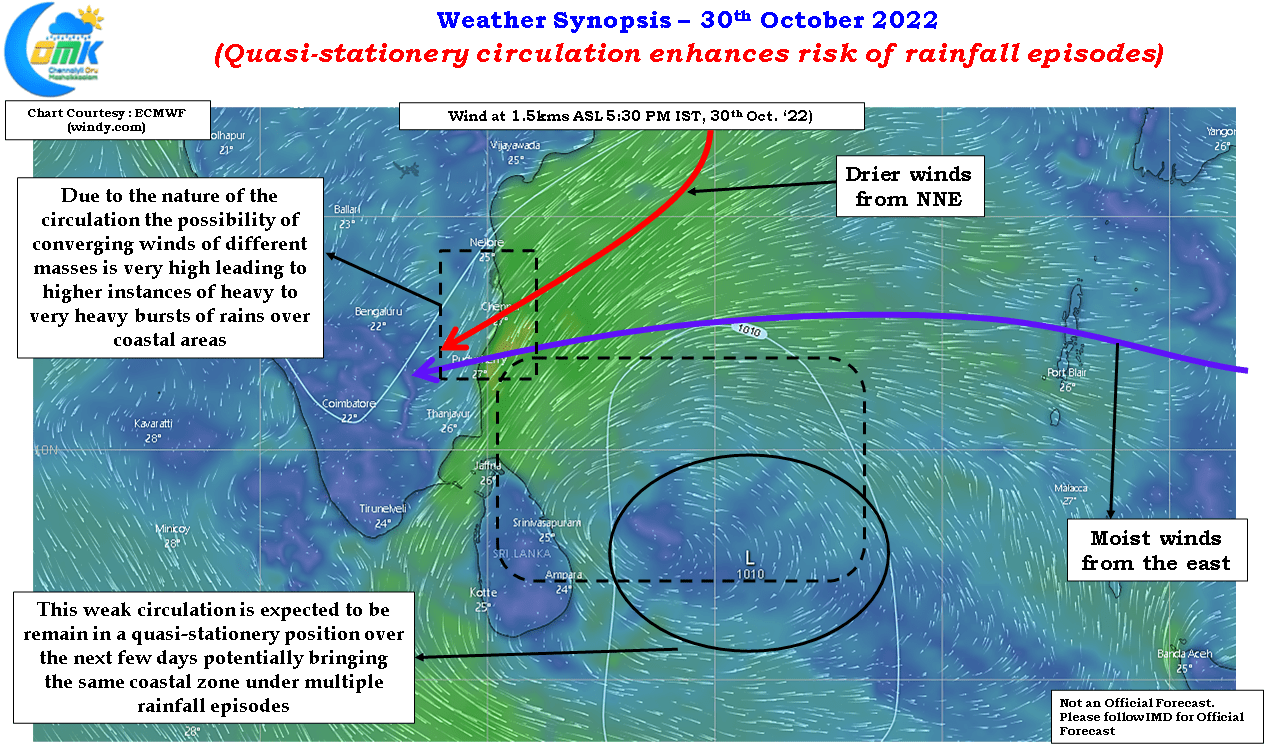
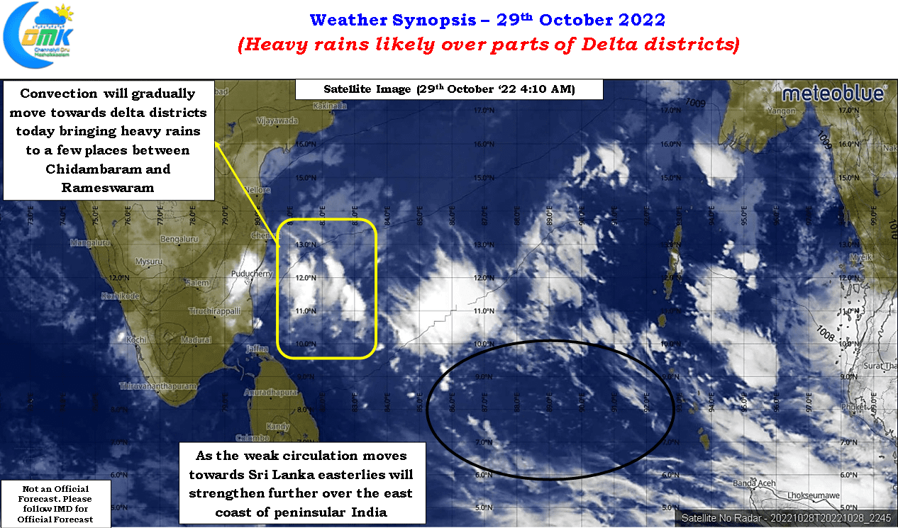
With the onset of northeast monsoon now behind us it is time to focus on what is likely to be the first active spell of this year’s monsoon which is almost upon us. The weak disturbance now seen over the south bay which played an important role in bringing the onset is likely to be the key actor in the upcoming spell of rains as well. Weather models while diverging on the potential impact in terms of rainfall intensify and areas of impact are in sync about how this disturbance, likely to evolve into an LPA or possibly remain a trough of low, is expected to remain around the coast of Tamil Nadu during the first 3 / 4 days of November leading to potentially sustained spell of heavy rains over coastal Tamil Nadu until end of next week.
It is in this context it becomes essential to look back at some of the events that happened during 2021 and 2020 when some of the urban clusters recorded burst of heavy rains in short duration time not only throwing the regular activities out of gear but also providing a difficult situation for the disaster managers in the administration as well. 2015 Chennai floods has become an urban legend now but if 2020 and 2021 taught us something it is pattern of urban areas getting extreme burst of rains in a short duration. The greater Chennai urban agglomeration saw multiple such events during 2021 with almost every major rainfall episode during the year associated with an extreme burst of rains. Studies in the recent times are slowly confirming the role of urbanization in impacting precipitation through enhanced lower level convergence. This study on the role of urbanization enhancing rainfall over Greater Houston area during Hurricane Harvey could be of interest to enthusiasts who would like to take up possible study of urbanization impact in the context of Indian sub continent.
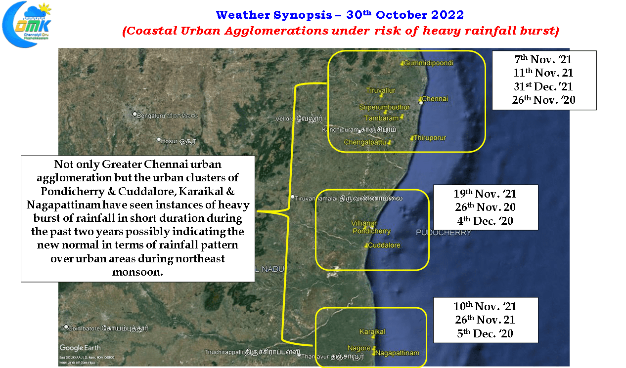
It is also essential one not only looks at greater Chennai alone but also look the other urban clusters as well where set of cities / towns which due to proximity between each other show characterestics of an urban agglomeration. The two clusters that have once again seen similar instances of extreme bursts of rains are the Pondicherry & Cuddalore cluster and Karaikal & Nagapattinam cluster. Interestingly both these clusters come under two different administrations making it a unique challenge for disaster managers in the administration.
One might wonder why such a long note on these urban clusters and rainfall episodes. In a way history always provides us with indicators on what future could look like. While it may not be exactly the same the experiences surely provide us a reason to be cautious when things are expected to become volatile. As explained in the early part of the post the upcoming few days could bring upon us the first active spell of NEM 2022. With weather models expecting a quasi stationery disturbance off the coast of Tamil Nadu we might potentially see a scenario where the same coastal zone could see bursts of rains continously. Nagapattinam, Thiruvarur & Mayiladuthurai dts saw one such episode when cyclonic storm Burevi stalled over Gulf of Mannar for more than 48 hours caught between two ridges.
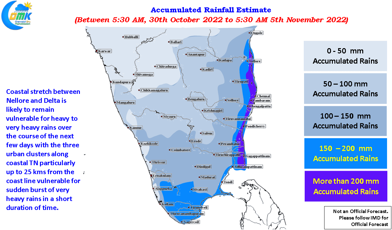
With the circulation expected to remain in a quasi stationery position to the NE of Sri Lanka we could potentially see a situation where parts of coastal Tamil Nadu between Chidambaram and Pulicat come under such episode of continous rains with bursts of heavy to very heavy rains. In a way this puts the two urban clusters, Greater Chennai and Pondicherry & Cuddalore urban cluster, under the spotlight for potential burst of heavy to very heavy rains in a short duration. Most coastal places between Sriharikota and Vedaranyam may get an accumulated rainfall of 20 cms or more during this period of active rainfall and it would not be a surprise if a few places see total accumulated rainfall exceeding 35 to 40 cms too. The increase in rainfall intensity is expected to start from later to night / early morning gradually picking up pace with Monday night & the early hours of Tuesday particularly vulnerable for burst of rains.
The objective of the post is not to spread panic but to bring about a perspective on the risk that exists with the conditions prevailing.