
For the last couple of days scattered thunderstorms have marked their presence over North Coastal Tamil Nadu during evening time after a hot afternoon. The important characteristic of these thunderstorms over the weekend was its ability to move across the coast towards the sea. This was indicative of the strengthening of the Westerlies allowing the thunderstorms to be pushed into the sea overcoming land / sea friction along the coastline. While as humans we are many times not happy with what we receive, particularly rains during summer months, it is fair to say most parts of Chennai and suburbs recorded atleast one decent spell of rains over the weekend.
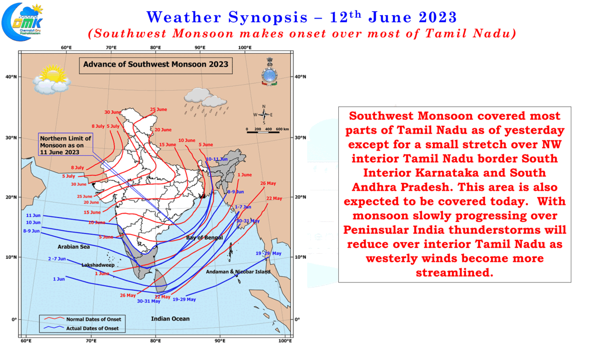
In a way this also confirms the onset of Southwest Monsoon over most parts of Tamil Nadu with IMD’s monsoon onset map indicating only a small portion of Northwest Interior Tamil Nadu adjoining South Interior Karnataka and and South AP still to come under the monsoon regime. Monsoon dynamics continues to be influenced by the presence and slow movement of Cyclone Biparjoy which intensified into an Extremely Severe Cyclonic Storm yesterday morning. 2023 becomes one of those rare years when we have had two Extremely Severe Cyclonic Storms on either side of the Indian Sub Continent during the Summer / Monsoon months.
Weather models continue to indicate Cyclone Biparjoy to landfall close to the Indo Pak border over the Kutch region of Gujarat as a strong cyclone on 15th. This is likely to bring not only rains to parts of NW India as the remnant circulation moves further east after landfall but also drag the monsoon dynamics as well. As Cyclone Biparjoy climbs further up more places along the Konkan coast will see the onset of Southwest Monsoon. Currently though monsoon has been favorable only to the coast and has been fairly weak as we move further East from the western coast. This will potentially improve when the remnant circulation of Biparjoy moves into Central India after landfall.
With monsoon picking up over Peninsular India we can see reduction in thunderstorm activity over interior and North coastal Tamil Nadu though we will not see a complete cessation of Veppasalanam thunderstorms due to the overall weaker than normal monsoon dynamics that is likely to prevail until Biparjoy makes landfall. Today we could see many places coastal Kerala come under fairly heavy spell of rains with few places in Central Kerala coming under intense monsoon rains during the day. Isolated thunderstorm activity is likely today over Salem and Erode districts while one or two places in Madurai, Sivagangai and Virudhunagar dt may see moderate thunderstorms later in the evening. As is the case more often a possible circulation, precursor to monsoon depression in Bay of Bengal, may create wind convergence for a window of thunderstorms for interior Tamil Nadu towards the end of the week, until then its going to be subdued days for Veppasalanam rains.
On the temperature front Summer has not yet gone for North Coastal Tamil Nadu and is likely to linger for a few more days like an uninvited guest due to the incoherent monsoon dynamics. Temperatures could see a visible difference only when the moisture from the west gets pushed across Peninsular India on a consistent basis bringing a layer of insulation until then the temperatures are likely to stay around 39 / 40°C for Chennai and suburbs. Additionally the delayed sea breeze could mean between 12 PM and 4 PM the temperatures around Chennai may consistently stay around 38 / 39°C for a week or so. What is in store for Chennai on the temperature front during third and fourth week of June will depend on how monsoon dynamics realigns after Cyclone Biparjoy completes its life cycle.