
Rogue “behaving in ways that are not expected or not normal, often in a way that causes damage“
Cambridge Dictionary
With the first fortnight of Southwest Monsoon season almost coming to an end except for Punjab, Ladakh (UT), Rajasthan, Himachal Pradesh, Andaman & Nicobar (UT) and Pondicherry (UT) all the other states are showing negative anomaly for the season on a cumulative basis. 15 states including Karnataka, Kerala, Maharashtra and Goa are currently under large deficit category indicating how poor the season has shaped up so far.
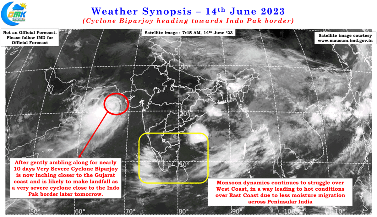
One could argue the delayed monsoon onset was the reason for the poor performance so far. While there is no doubts the Indian summer Monsoon is a much larger phenomenon almost on a global scale the intra-seasonal performance of the monsoon depends on many factors some global and some local. One such factor that is still persisting and influencing monsoon dynamics is the very severe Cyclone Biparjoy which lies about 350 kms west of Porbandar. After deepening into a Low Pressure Area from a cyclonic circulation on 5th May it is now 10 days it has been ambling along in a general northward direction over the Arabian Sea inching closer to the Gujarat coast. With another 36 hours or so still left for a landfall over the Indo Pak border this system has pretty interfered with monsoon dynamics for the entire first fortnight.
During this period the favorable influence of West to East moving MJO was completely absorbed by Cyclone Biparjoy helping it to intensify into an Extremely Severe Cyclonic Storm leaving the monsoon dynamics high and dry. Weather models indicate MJO is about to move into Maritime continent after passing through the east Indian Ocean. This now means monsoon dynamics now looks to Bay of Bengal for getting itself back on track. This becomes critical as further East movement of MJO from Maritime Continent will bring an overall suppressed atmospheric conditions over Indian Ocean leading to long term question marks for the first half of the Southwest Monsoon season.
While question marks linger on Southwest Monsoon in an indirect way the current incoherent monsoon dynamics is also influencing weather over Tamil Nadu. North coastal Tamil Nadu is experiencing an extended summer on account of drier conditions prevailing. While the seasonal westerlies ensure sea breeze arrival over coastal places like Chennai is delayed until late afternoon, the poor moisture migration over Peninsular India has mean land temperatures over places to the west of Chennai has not sufficiently cooled enough to bring down the heat over coastal places.
All in all an immediate respite from the current spell of heat over Chennai and suburbs looks unlikely to happen. Meanwhile a more streamlined westerlies now Cyclone Biparjoy has moved further up will also mean reduced thunderstorm activity as wind instabilities reduce over interior Tamil Nadu.