
It is common knowledge the Northeast Monsoon season coincides with the peak cyclone season over North Indian Ocean Basin. The period April / May is the pre monsoon cyclone season and the October – December period is the post monsoon cyclone season. The cyclone season coinciding with the rainfall season is possibly one of the reasons why it is tough to make a relatively good long term inference on the seasonal rainfall estimate during Northeast Monsoon. While Easterlies bring a lot of rains, like the current year in context, when Chennai and suburbs have recorded more than 500 mm rains despite most disturbances taking an unfavorable track.
But often one disturbance has changed the seasonal rainfall dynamics completely, like Cyclonic Storm Nisha in 2008, which dumped a lot of rains all the way from Delta to Chennai during a phase when it was nearly stationery for 24 hours off the TN coast. 2016 which was one of the worst years in recent memories ended up as a normal year for North coastal areas like Chennai because of favorable movement of two disturbances Nada and Vardah. The rest of the state though was not lucky leading to one of the largest deficits in recorded history of Northeast Monsoon. Effectively many a times seasonal performances have hinged a lot on these disturbances / cyclones and favorable tracks are often essential to bring large scale widespread rainfall events during Northeast Monsoon periods.
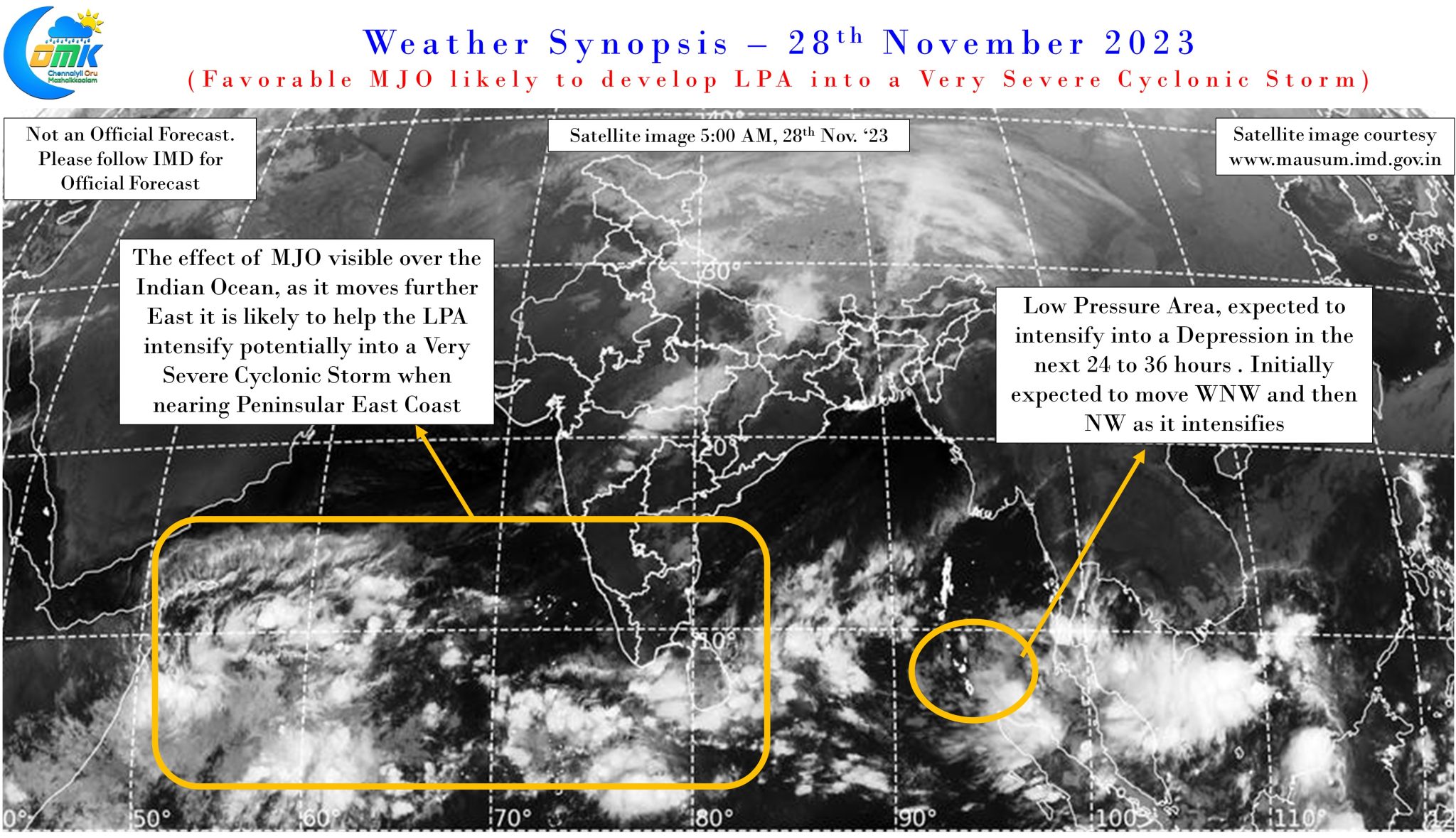
IMD confirmed the development of Low Pressure Area over South Andaman Sea and adjoining Malacca Strait yesterday from a circulation that moved in from Gulf of Thailand. In our earlier preliminary post on this disturbance we had indicated about how complex dynamics is likely to make it a cat and mouse game in terms of identifying potential track and impact zone. While weather models continue to show wide ranging scenarios with regards to the eventual track and destination there appears to be increasing consistency on the eventual impact zone being Peninsular India rather than a Northeast recurve towards Bangla coast as many models had initially suggested.
There is also increasing consistency among weather models that this LPA has the potential to intensify up to a Very Severe Cyclonic storm over the next few days as it takes its journey all the way from close to Banda Aceh to Peninsular East Coast. It is expected to intensify into a depression in the next 24 to 36 hours taking a WNW track initially strengthening into a Cyclonic Storm around 1st Dec.’23. Post becoming a cyclonic storm as it intensifies into a Severe Cyclonic Storm and then a Very Severe Cyclonic storm around 2nd / 3rd December it could take a more NW track possibly heading East of Chennai at some point of time around the early hours of 4th December. The rainfall prospects for Chennai will depend on how close the disturbance comes to Chennai. There is a fair consistency among weather models this NW track could take the eventual landfall to South AP close to Kavali as a Very Severe Cyclonic Storm during the evening / night of 4th December.
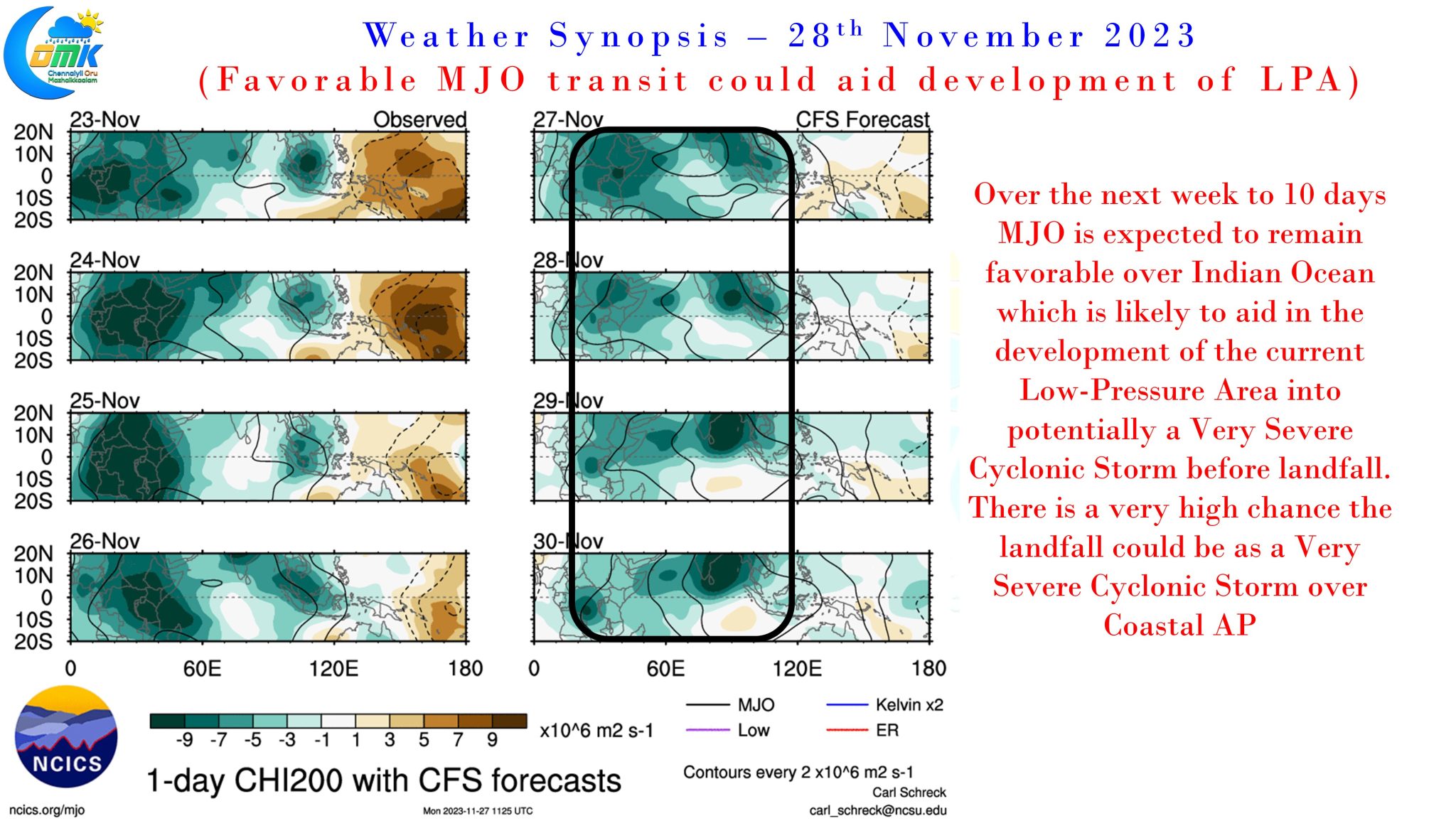
The presence of MJO over Indian Ocean and it is gradual East movement over the next couple of weeks is going to greatly influence in the enhancement of this LPA into a Very Severe Cyclonic Storm. This could also eventually play a role in the system having its eventual landfall over the Peninsular Coast rather than Bangladesh coast.
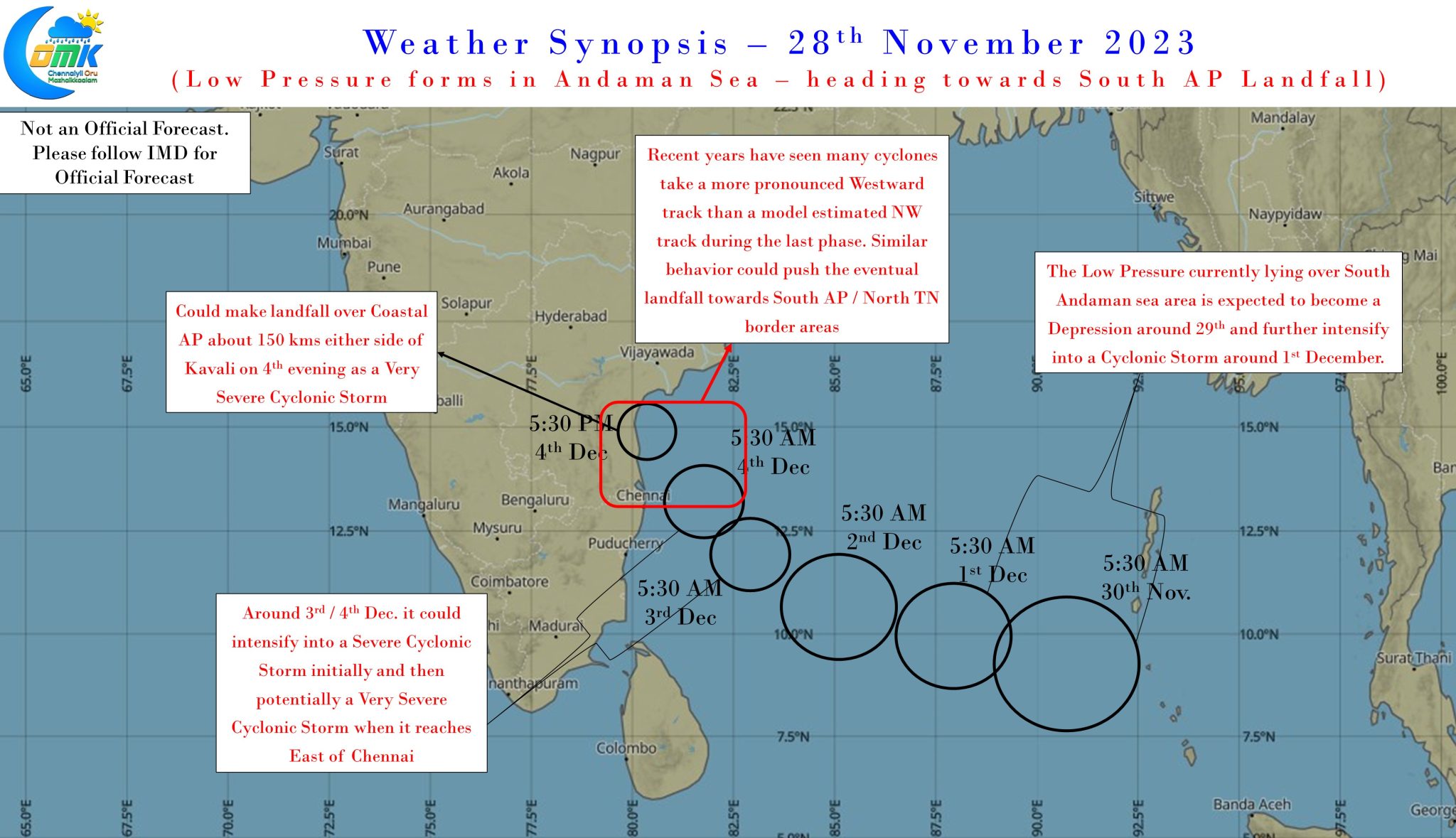
The point when the disturbance is East of Chennai is not only critical for the rainfall prospects of North Coastal TN but also very critical in one another aspect as well. Over the past few years we have seen many cyclones like Gaja, Thane, Vardah etc take a more pronounced Westward track than the initially weather model estimated NW track pushing the eventual landfall between 100 to 200 kms south of the initial landfall estimates. While weather model accuracies have greatly increased recently in terms of cyclone landfall this is a possibility one needs to keep a watch which could potentially alter the impact zone pushing it closer to South AP / North TN border areas rather than closer to Kavali as current estimates show. Clarity on the rainfall prospects for Coastal TN will be clearer once the LPA becomes a depression and there exists increasing consistency on the track, particularly how close could it come to the TN coast on its journey towards AP coast.
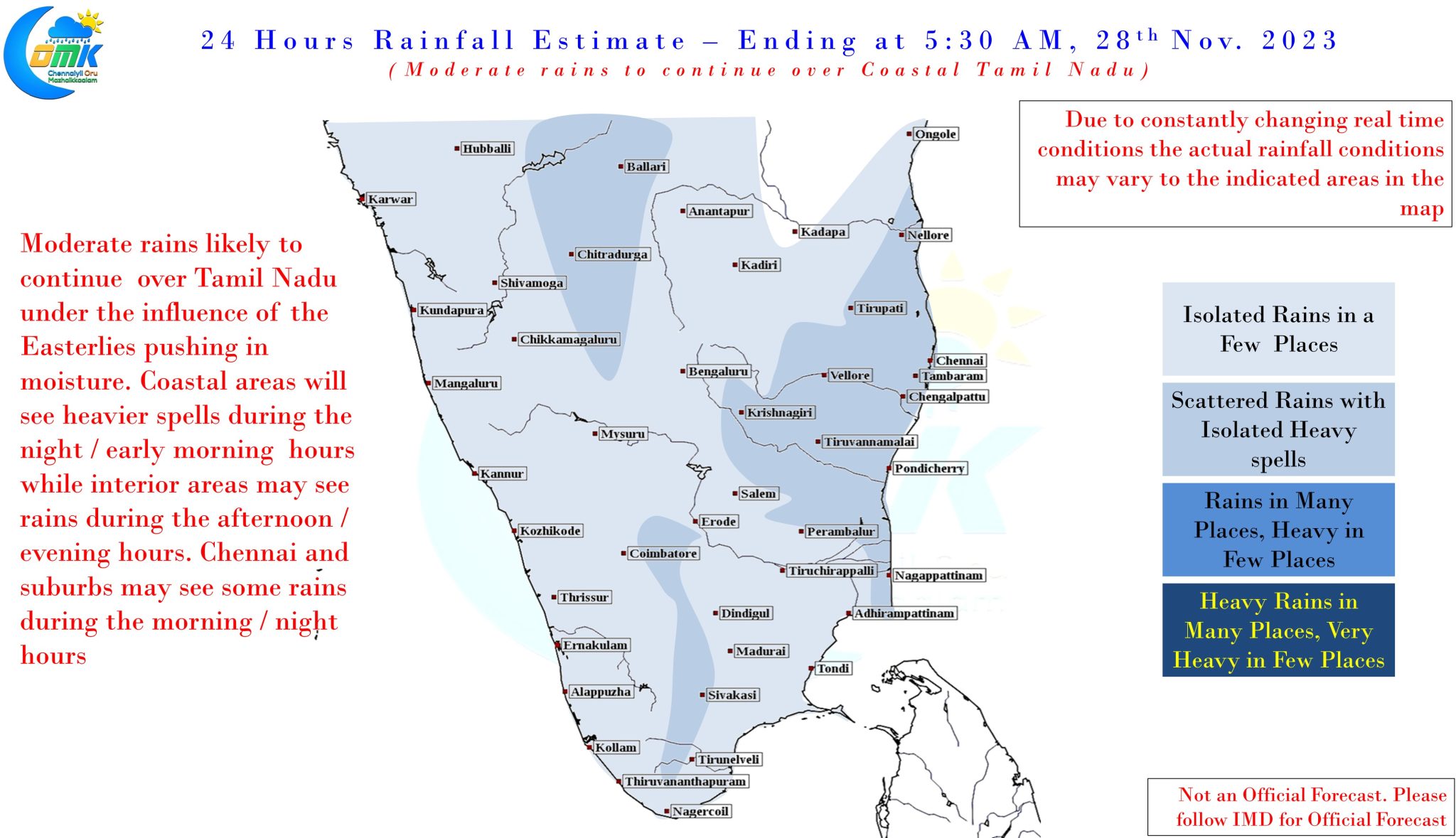
In the meanwhile over the next couple of days moderate rains would continue over most areas of Coastal Tamil Nadu with some of the interior areas also seeing thunderstorms from the remnant moisture moving in from the coastal areas. These Easterly driven rains will continue to keep the seasonal rainfall meter ticking in a slow but steady manner. Chennai and suburbs may continue to see rains during the morning / night hours with heavy spells at times depending on storm movement.
Once there is some more consistency and clarity, particularly the point where the system comes closer to TN coast, a fresh update on the rainfall prospects from this disturbance will be updated.