
“On the edge of your seat“
very excited, and giving all your attention to something, because you want to know what is going to happen
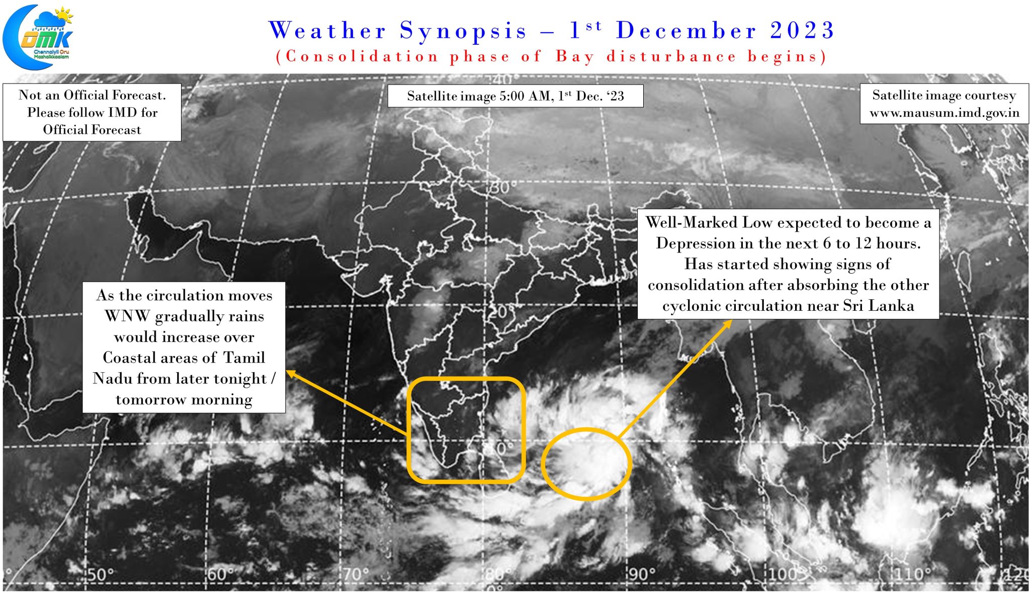
The Northeast Monsoon season coinciding with the post monsoon cyclone season over North Indian Ocean gives on many occasions gives weather blogger an edge of seat thriller experience while tracking cyclones in Bay of Bengal. The adrenaline rush is not only to understand where it could potentially make a landfall but also figure out rainfall prospects as well, particularly when it throws up delays / stalls during its journey.
The current disturbance in Bay of Bengal is possibly heading as one more thriller with weather models providing diverging scenarios ranging from Chennai to Burma as though reiterating the strong bond Chennai shares with Burma through its regular presence of Tamilian community in Myanmar from time immemorial. Gradually things have started to align with increasing consistent on not only the potential path but also the potential zone of landfall / land interaction. With most models leaning towards a NE recurve scenario there is a conscious use of the phrase land interaction in today’s post rather than just using landfall. This also now gives a clearer indication on what to expect for Tamil Nadu over the next few days from this cyclone.
Today’s post aims to decode the entire journey in three phases, the first phase when the current well marked low intensifies into a Deep Depression / Cyclone and travels from NE of Sri Lanka to East of Chennai latitude. This phase will possibly coincide with the best rainfall prospects for Tamil Nadu. A caveat though at this point, considering the expected movement of the cyclone the prospects of rainfall for interior Tamil Nadu looks less, particularly South & West interior TN. North interior TN may benefit from spill over effect when the cyclone comes closer to the North TN Coast. During this phase we could expect widespread rains along the coast between Delta and Chennai. The rains could increase in intensity if the Deep Depression / Cyclone in real time is closer to the coast than model estimates.
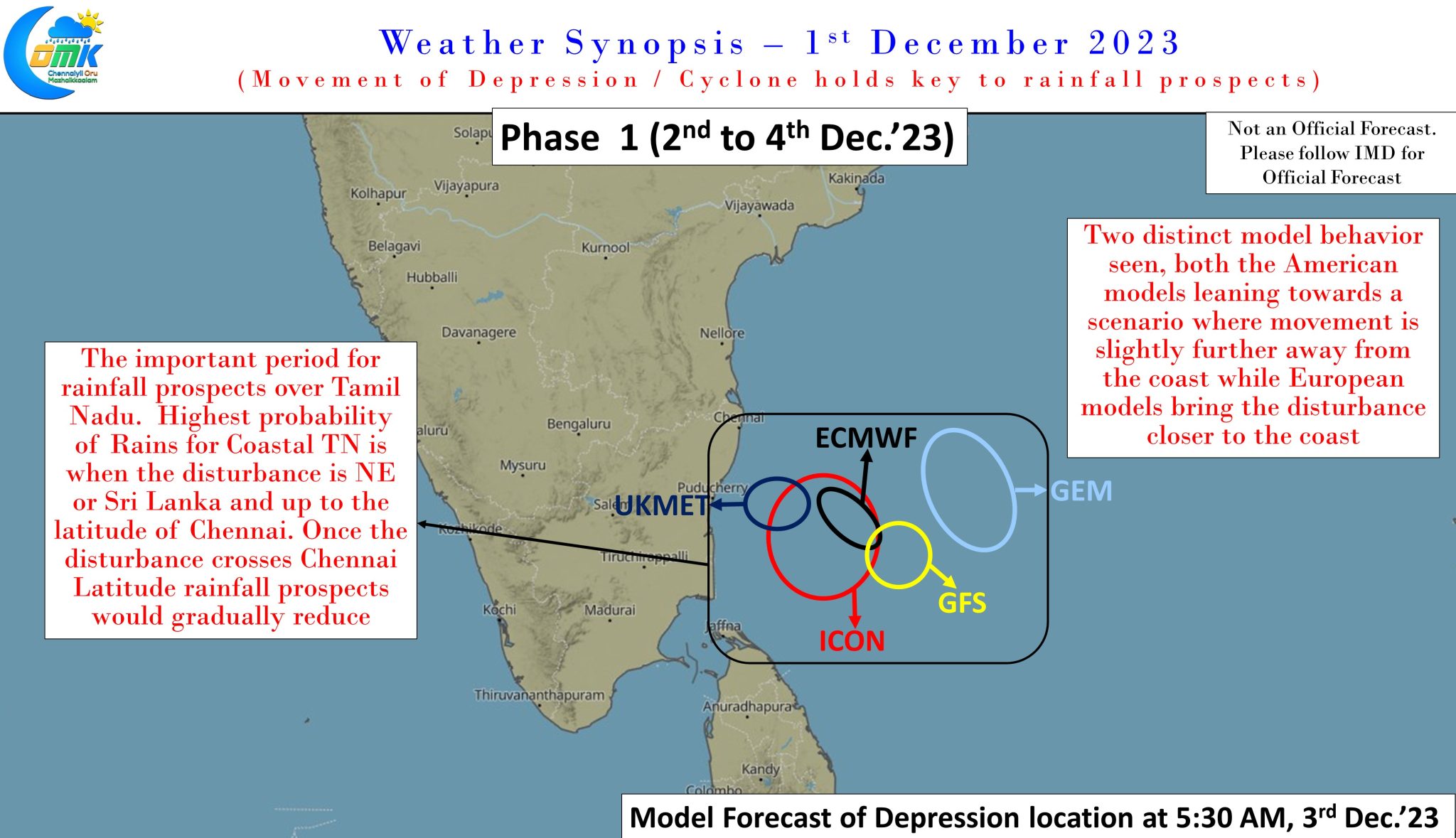
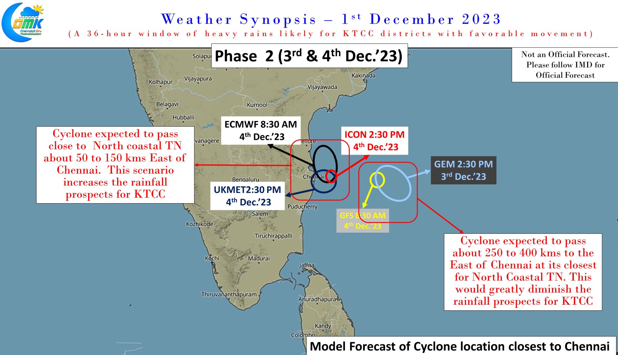

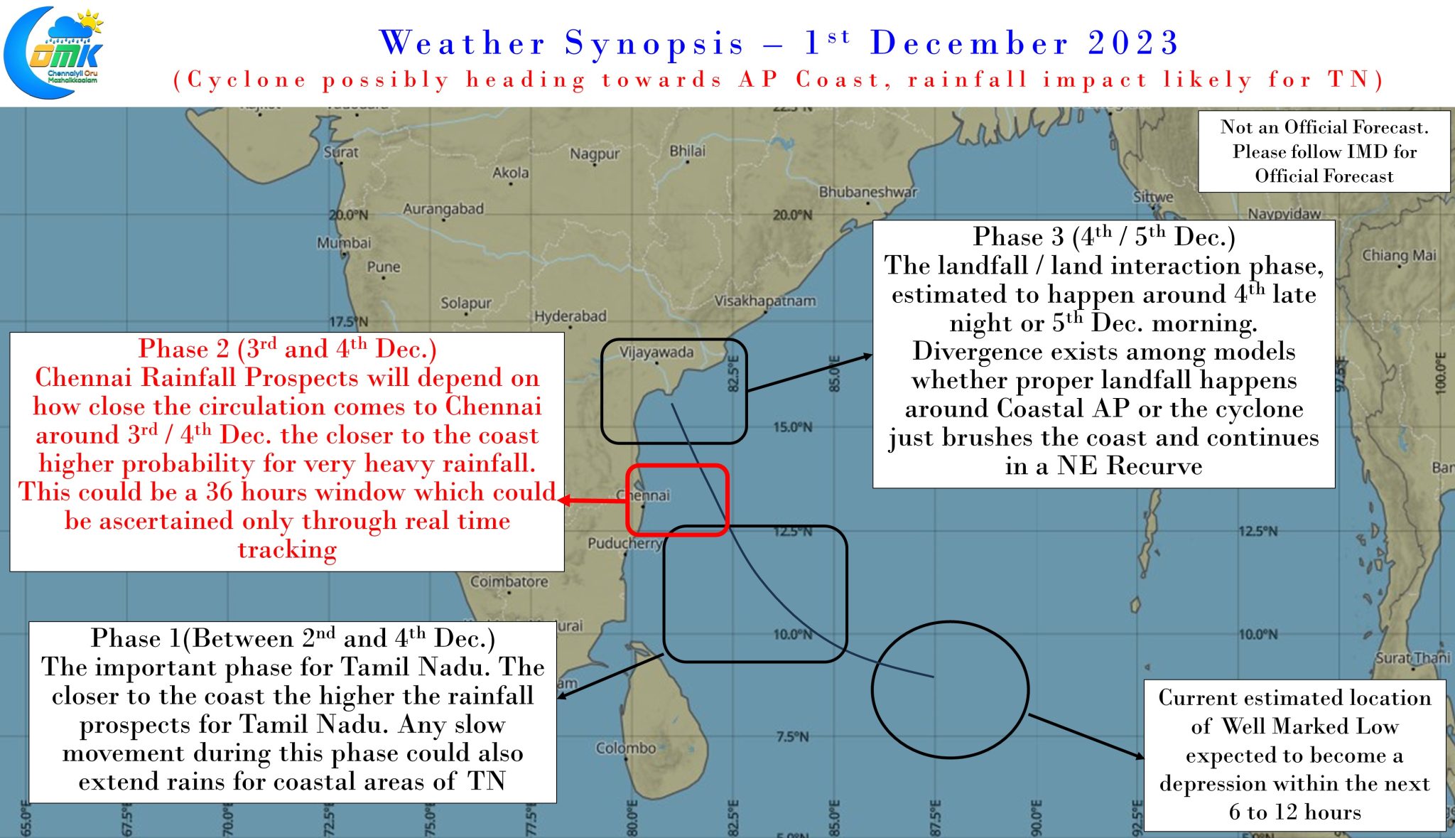
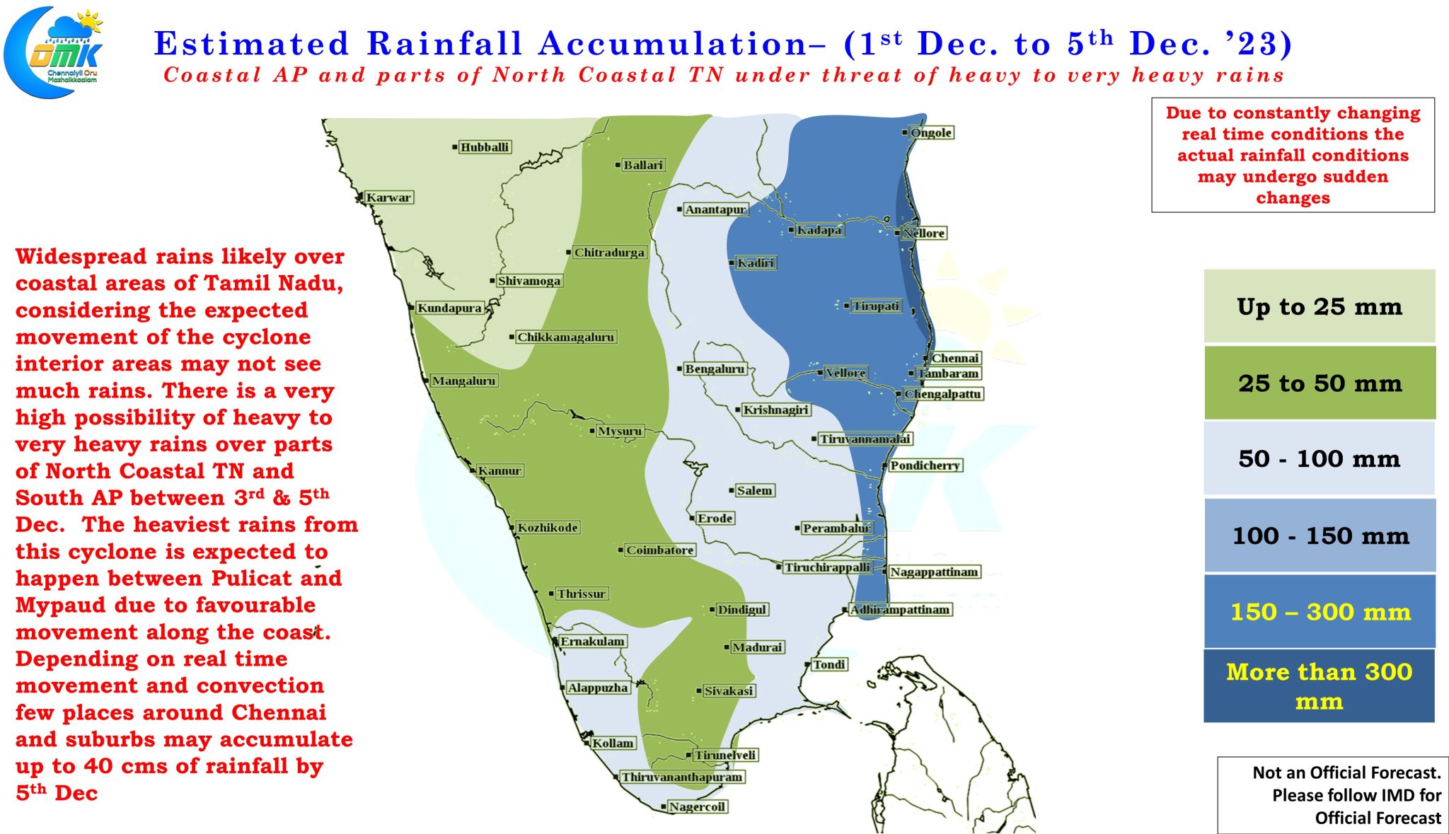
The second phase of the journey is specific to the KTCC districts when the cyclone comes close to Chennai. While there is two distinct model behavior seen with one set of models bringing the cyclone as close as between 50 to 150 kms to Chennai while the other keeps the cyclone about 250 to 400 kms away from Chennai. In the case of the first scenario KTCC could come under heavy to very heavy rains on 3rd and 4th December as the cyclone possibly makes a brush against North Coastal TN. In the event of the second scenario when the cyclone is further away from the coast line the rains could be considerably lesser. If one were to analyze the model behavior during the 1st phase both GEM and GFS seem to push the circulation much further away from the coast, and that gets reflected in the entire journey until landfall.
This brings us to the third phase of the journey which involves landfall or land interaction over coastal AP. There is increasing consistency among models about a potential landfall / land interaction over coastal AP with almost every model confirming this. Once again two distinct model behavior seen. The first set comprises of the European model that brings the zone of landfall / land interaction between Kavali and Machilipatnam while the second set, the American models that take the landfall / land interaction between Kakinada and Vishakhapatnam. Except for ICON pretty much all the models are indicating a potential landfall. Most models are also indicating the remnant circulation after landfall to move along the coast towards Odisha / West Bengal dumping a lot of rains during the process.
To summarize.
- The Well Marked Low currently over South bay is expected to intensify into a depression in the next 6 to 12 hours, further intensify into a Cyclone over the next 36 to 48 hours.
- Coastal Tamil Nadu is likely to see widespread rains from later tonight / tomorrow morning. Initially delta districts may see the better spells with rains gradually shifting North as the circulation climbs up.
- There is increasing consistency on the cyclone making landfall / land interaction over Coastal AP between Kavali and Kakinada.
- There is a very high possibility while on its way towards Coastal AP the cyclone could brush North Coastal TN at roughly 100 kms distance which is likely to bring heavy to very heavy rains over many places in KTCC districts on 3rd & 4th December.
- Post landfall / land interaction the remnant circulation may move along the coast towards Odisha / West Bengal bringing rains to these areas after 6th December.
- Depending on real time movement and convection few places around Chennai and suburbs may accumulate up to 40 cms of rains by 5th December.
- The heaviest rains from this cyclone is likely to fall between Pulicat and Mypaud near Nellore along the coastline.