
Catch someone off guard
to surprise someone by doing something that they are not expecting or ready for
Exactly two weeks back to the hour the discussions among not only weather bloggers but also common people were about Cyclone Michaung and its potential brush with Chennai. There were a lot of sceptics on whether Chennai would get the rains or was it an unnecessary hype of the rainfall threat not only by the weather bloggers but also IMD which had to their credit estimated the track of Cyclone Michaung accurately very well in advance. The 24 hours between Sunday evening and Monday evening may have gone a long way to correct the tendency among a majority of the public at large to ignore weather warnings. There are times when a natural disaster of unimaginable proportions to bring about a learning and course corrective measures. A large portion of the Disaster Resilience in Odisha state has been driven by their course correction subsequent to the 1999 Odisha super cyclone.
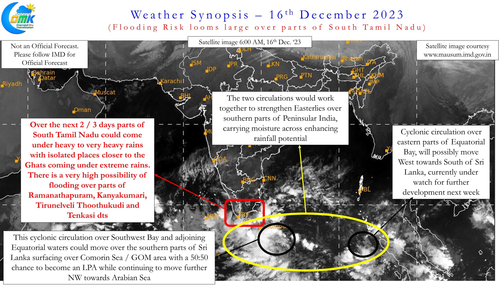
In a way today’s post is also an attempt to make people be aware of a potential flood threat that looms large over parts of South Tamil Nadu. Many a times the damages are always higher when one is caught off guard. Cyclone Ockhi is a classic example of how damages could get magnified if one is caught unaware. Often a circulation over GOM / Comorin Sea has the potential to bring heavy to very heavy rains over South TN and along the Ghats as it drags moisture through the Easterlies across the extreme southern parts of Peninsular India. While the strength of the circulation is always a factor in most coastal areas, as far as GOM is concerned even a Low Pressure Area is capable of creating havoc under the right circumstances.
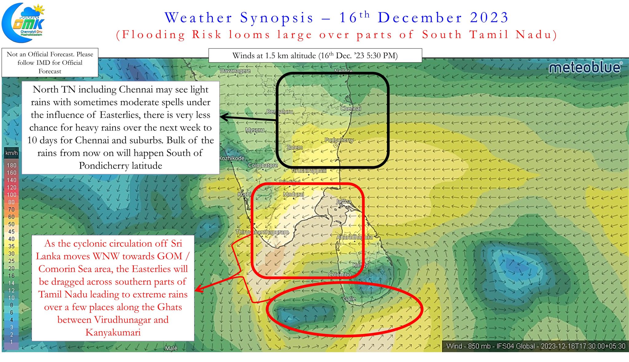
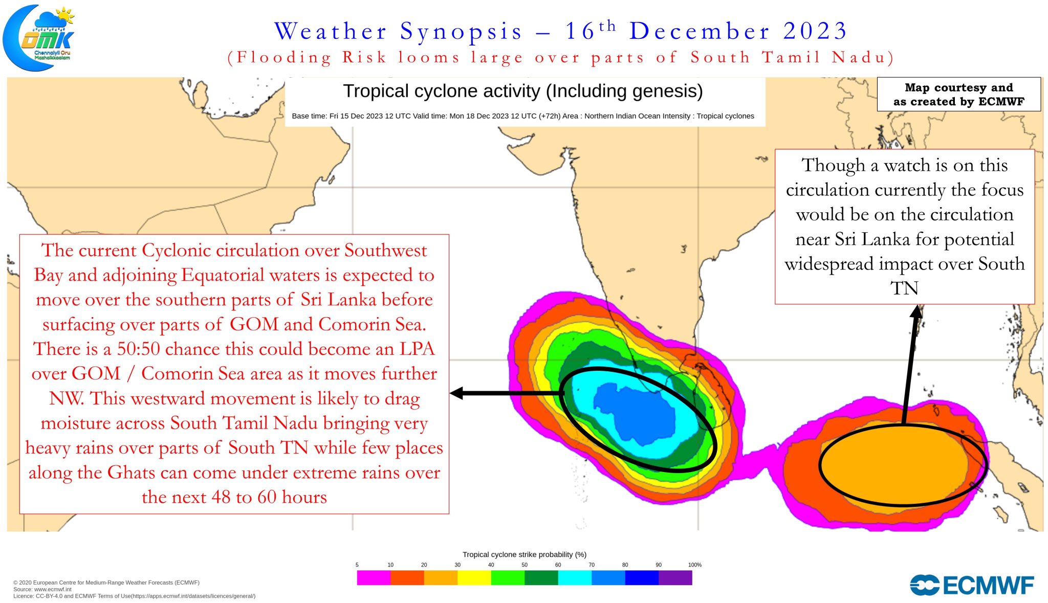
Satellite image indicates the cyclonic circulation being in the vicinity of SE coast of Sri Lanka along the Equatorial waters. There is increasing consistency among the weather models this cyclonic circulation could move in a WNW direction over the southern parts of the island nation and subsequently surfacing over parts of Comorin Sea / GOM area. There is a very high chance this could strengthen into a Low Pressure Area by the time it reaches Comorin Sea area while moving NW towards the southern parts of Arabian Sea. It is this WNW and subsequent NW movement along with strengthening that is a matter of concern as weather models tend to under estimate the potential rainfall scenario when moisture gets trapped in some of the valleys along the Ghats. Places like Manjolai, Oothu etc over the southern Ghats in Tirunelveli district are vulnerable for extreme rains in these conditions. It would not come as a surprise if one or two places around the Tirunelveli Ghats accumulate as high as 400 mm over the next five days or so.
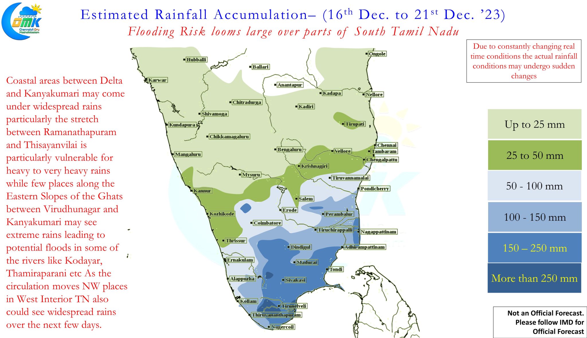
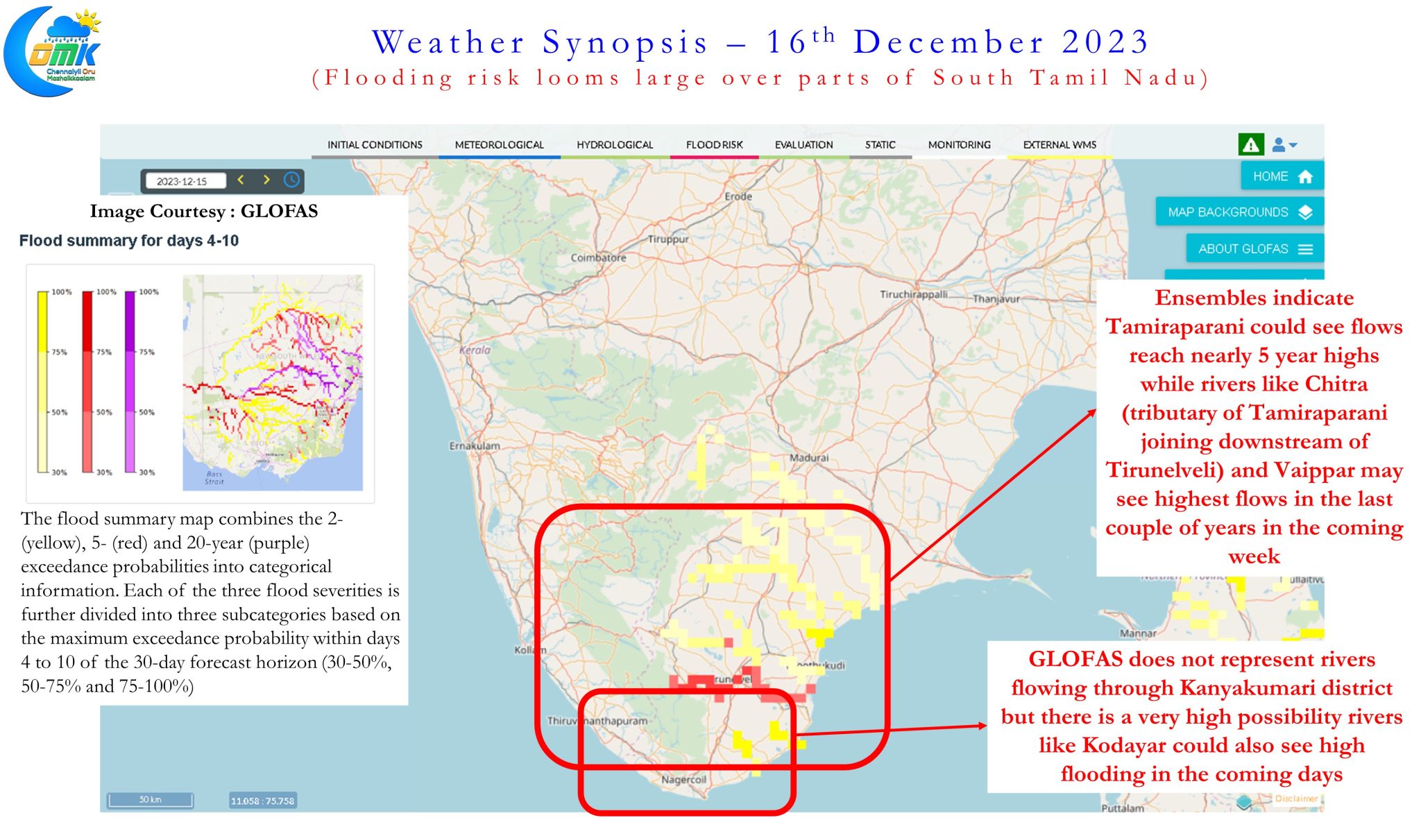
Though the ECMWF based Global Flood Awareness System (GLOFAS) in the past has not performed well in picking up flood scenarios in South Tamil Nadu, looking at the current forecast based on the initial conditions of 15th Dec.’23 and the rainfall scenario estimated based on wind pattern there is a fairly high degree of confidence rivers like Thamiraparani, Kodayar and Vaippar may see flows that could potentially create flooding risk over parts of Thoothukudi, Tirunelveli, Tenkasi and Kanyakumari districts.
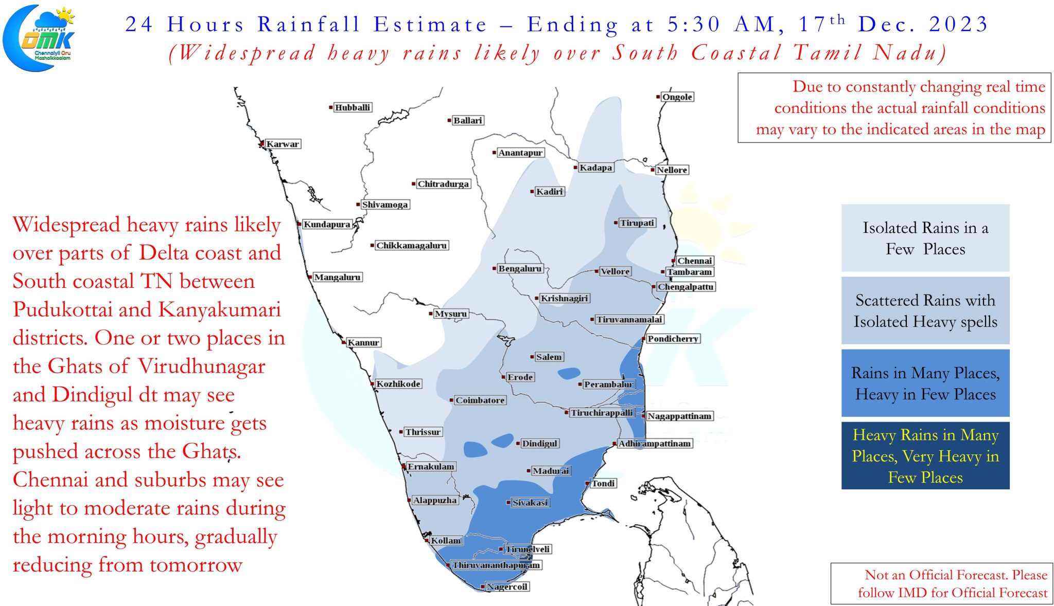
Over the next 48 to 60 hours widespread rains are expected between Delta and South TN coast. In particular the stretch between Ramanathapuram and Thisayanvillai is vulnerable for very heavy rains as the circulation moves across Sri Lanka. Gradually as the circulation moves further West the moisture starts getting accumulated and trapped in some of the East facing valleys in the Ghats between Virudhunagar and Kanyakumari district leading to extreme rains in a few places. As mentioned above places like Manjolai and Oothu etc are very vulnerable for this scenario. With Sabarimalai season currently underway a lot of people visit Coutrallam falls as part of their pilgrimage to the Ayyappan temple. There is a very high chance of floods in not only Coutrallam falls but also Manimuthar falls which tourists should be wary off.
As far as Chennai is concerned over the next 36 hours light to moderate rains may happen, particularly during the morning hours, before gradually reducing. There is increasing confidence over the next week to 10 days there is very less chance for Chennai to receive heavy rains. Bulk of the rains from now on will be south of Pondicherry latitude.