
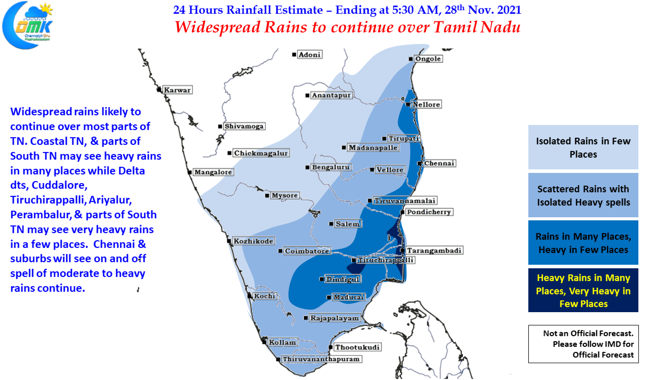
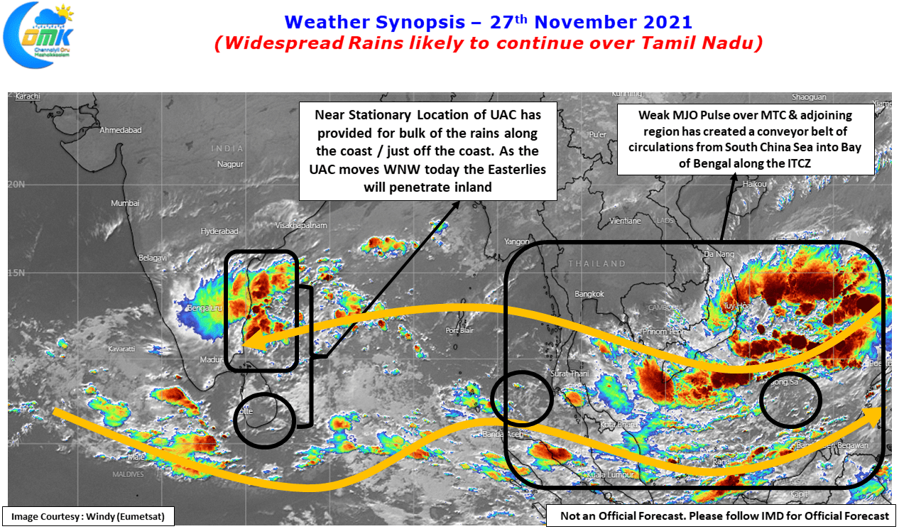
After the extreme rains over Thootukudi on Thursday, Northeast Monsoon continue to remain active along the coastal areas of Tamil Nadu though fortunately no area witnessed any extreme spell of rains due to the near stationary position of the Upper Air Cyclonic Circulation over Sri Lanka & adjoining region. The quasi stationary position meant while wind convergence did happen as estimated by models the Easterlies were struggling to penetrate inland bringing the bulk of rains just off the coast & along the coast. IMD AWS at Kattupakkam recorded 15 cms while many places along the coast & in Chennai and surroundings recorded about 10 cms.
The developing events once again confirm our choice of sticking to 24 hour weather inferences indeed is the way to go considering how fast dynamics are changing. With the presence of a weak MJO pulse of Maritime Continent & adjoining areas of Bay of Bengal creating conducive conditions for a conveyor belt of circulations from South China Sea to Bay of Bengal. If early this week what looked like a firm event likely to happen in the form of a possible Low Pressure Area over GOM / Comorin Sea was scuttled by the expected arrival of a fresh pulse into Andaman Sea around today which was expected to become the dominant circulation & evolve into a Low Pressure Area. IMD has possibly this in mind when they expected a possible LPA around 29th Nov. in Andaman Sea.
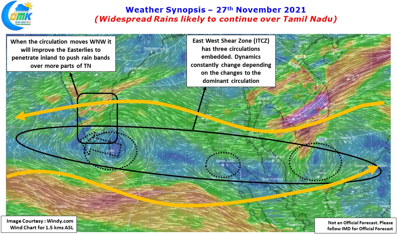
But not only the Hunter becomes the Hunted occasionally in the forests, even in weather we can see occasionally such a scenario. The Hunter is now slowly becoming the Hunted because of the possible arrival of one more fresh pulse early next week which is likely to give no room for the Andaman pulse to become an LPA. It is completely a different matter that even this scenario could change considering how fast things are changing even within the 24 hour scenario.
With weather models indicating the Upper Air Cyclonic Circulation over Sri Lanka likely to move WNW under the influence of the next circulation coming in the conveyor belt we could finally see the Easterlies penetrate inland. This strengthening Easterlies could bring rains not only to coastal Tamil Nadu but for some of the interior areas as well in districts like Dindigul, Madurai, Trichy, Karur etc which could see heavy rains at many places. Delta dts & parts of Trichy, Thanjavur & Pudukkottai dt could see very heavy rains in one or two places.
In the meanwhile Chennai & suburbs will continue to receive on and off spells of rains today as well interspersed with heavy spells of rains, particularly later in the night when the circulation shifts west. One or two places around the city & suburbs could receive very heavy rains depending on movement of the storms