
கடுகு சிறுத்தாலும் காரம் குறையாது.
Continuing with the tradition of each cycle of UAC / LPA / Depression marked by a burst of extreme rains, parts of Thoothukkudi district came under very heavy spell of rains as many places in the district recorded more than 20 cms of rains in a few hours. Chennai on 7th November, parts of Delta on 10th November, many parts of Kanyakumari, Tiruneveli & Tenkasi dts on 13th & 14th November, Pondy, Cuddalore & Villuppuram dt on 18th November were all episodes of very heavy rains which happened in a few hours. Of course interior parts of Peninsular India recorded their own version of very heavy rains particularly during the ending stages of the 92 B depression cycle.
IMD has called off the current Upper Air Cyclonic Circulation over Sri Lanka & surrounding areas to strengthen into a Low Pressure Area instead they have announced the following pulse coming into Bay of Bengal from South China sea in a couple of days time to become an LPA over Southeast Bay. Coming now to the opening remarks of today’s post it is not the name of the disturbance that is going to decide the Rains it might give but the nature of the disturbance that decides how heavy the rains would be. We have seen at times Cyclones washing ashore as a skeleton with hardly any rains while some depressions like 92 B have created havoc over a larger area.
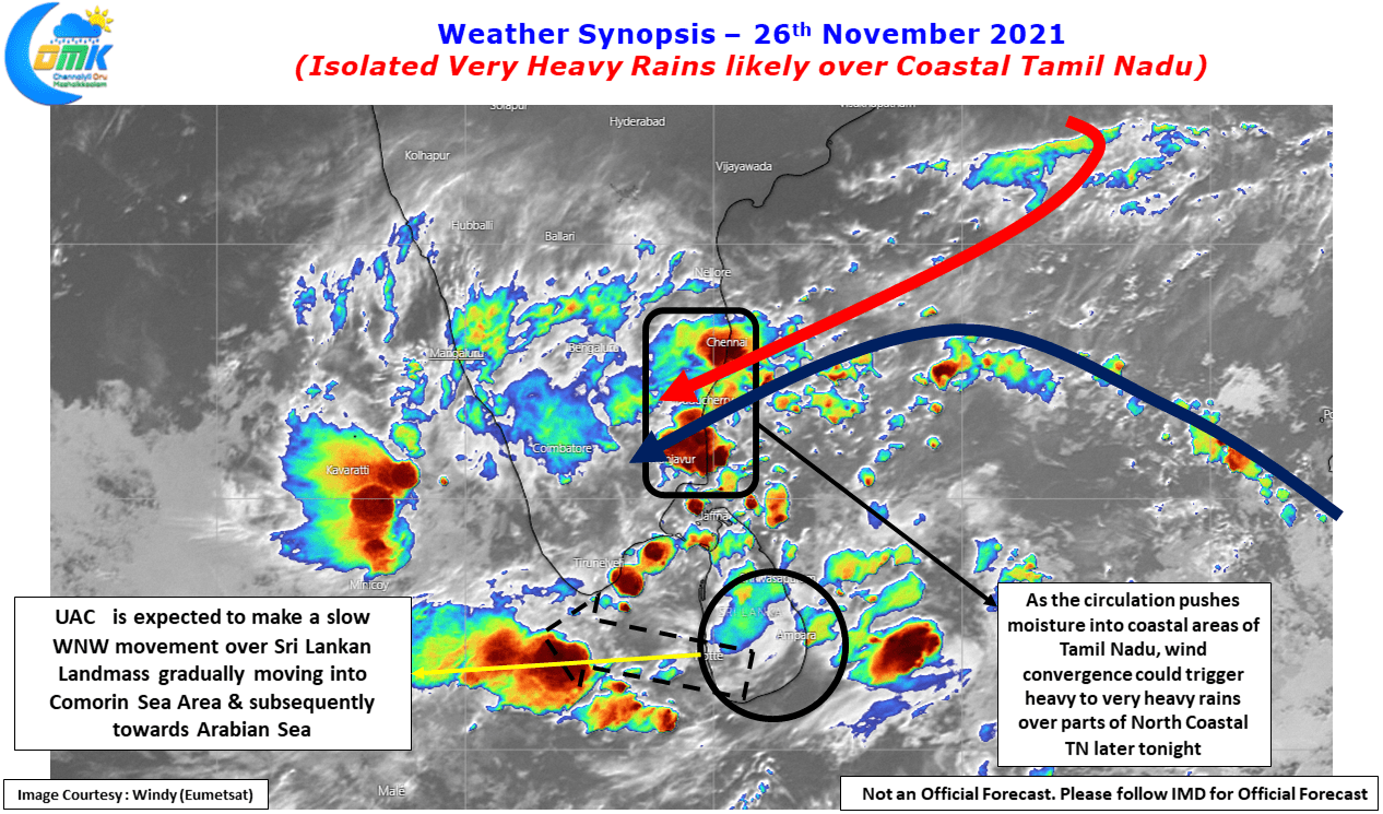
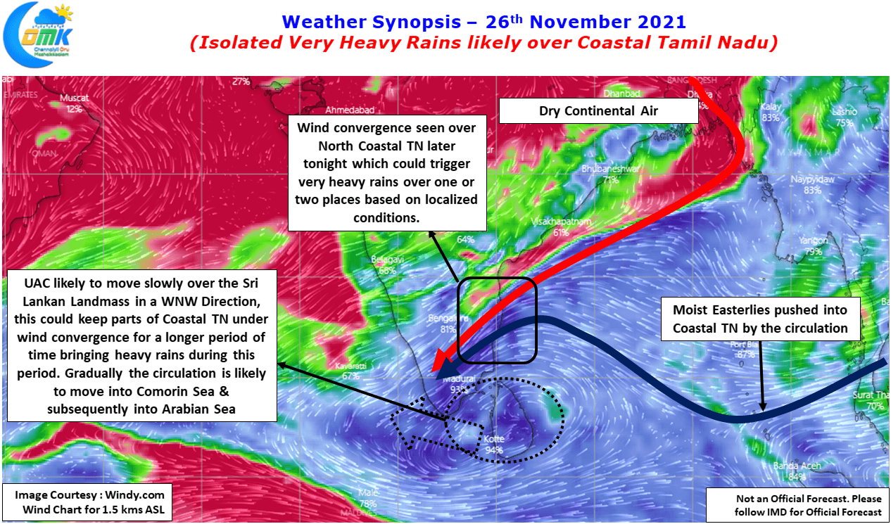
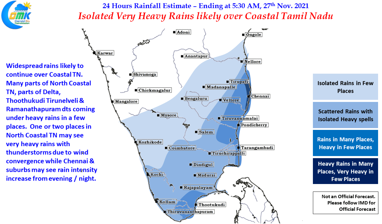
The key to the entire thing is how the dynamics play out overall and whether there are factors that could trigger a potentially heavy episode of rains. This NEM season quiet a few heavy rainfall episodes have happened due to wind convergence & yesterday’s rainfall episode over Thoothukkudi is no exception. Similarly wind charts indicate parts of North Tamil Nadu may come under wind convergence later today evening / tonight which brings the risk of heavy to very heavy rains over one or two places between Chennai & Cuddalore.
The exact impact area may be difficult to pin point due to the fact many a times the real life wind pattern may not exactly mirror the model estimated wind pattern. By nature Dry line thunderstorms are a narrow patch of storms which forms under favorable conditions when air particles of two different masses collide. In this context it may be reminded Friday & Saturday could bring about one such extreme over the North Coastal Tamil Nadu area that is likely to be similar to the incidents mentioned in the earlier part of the post.
Chennai & Suburbs may see an increase in intensity of rains from later today evening and is likely to continue well into tomorrow as well. Depending on the intensity of the rains some localized flooding water logging may happen in a few areas. Once again reminding our readers it will make sense to take one day at a time and the events over the past 24 hours or so confirm the same.