
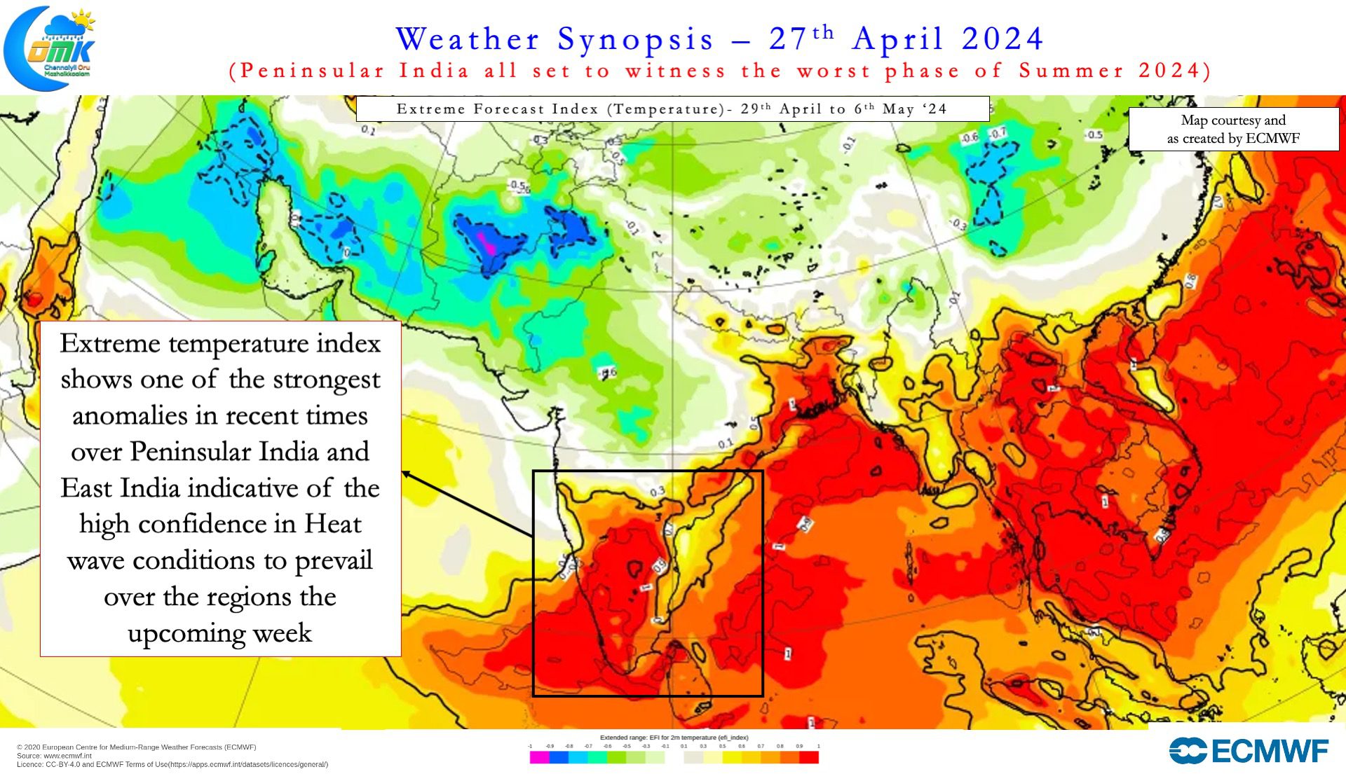
It is no understatement to say Summer this year has been brutal so far over the interior areas of Peninsular India. Cambridge Dictionary calls Weather as “the conditions in the air above the earth such as wind, rain, or temperature, especially at a particular time over a …”.Pattern as “a particular way in which something is done, is organized, …”. It also indicates Weather Pattern as words often used together. But many a times we tend to forget Weather works on patterns or “Rhythm” as well. There are seasonal changes, ebbs and flows not only in winds, but also in rains during monsoons as well. These rhythms have developed and evolved over the years. Subtle changes in earth and its dynamics bring about gradual changes to the rhythms which takes decades to identify.
Waves of the sea are an example of rhythm as well rising and falling. Marupadiyum by noted film maker Balu Mahendra features a lovely song written by Vaali. கிழக்கினில் தினம் தோன்றும் கதிரானது மறைவதும் பின்பு உதிப்பதும் மரபானது கடல்களில் உருவாகும் அலையானது விழுவதும் பின்பு எழுவதும் இயல்பானது. It may be ironical for many to read a philosophical spin to brutal Summer heatwave conditions. Let us make no mistake Weather models have been consistent about this spell of abnormally hot spell for Peninsular India.
Most models not only indicate temperatures may soar to 41 / 42°C across Tamil Nadu reaching 43°C in a few places. Afternoon temperatures over the next week to 10 days could be 4 to 6°C above normal as well. Starting from 1st May we could see heatwave conditions over large parts of Peninsular India including most of Tamil Nadu. This period also coincides with strong continental winds (Land Breeze) over the Northern parts of Peninsular India. Strong offshore winds over southern parts of Peninsular India will also play a role in temperatures. As sea breeze benefit wanes coastal places like Chennai will also see increase in temperatures.
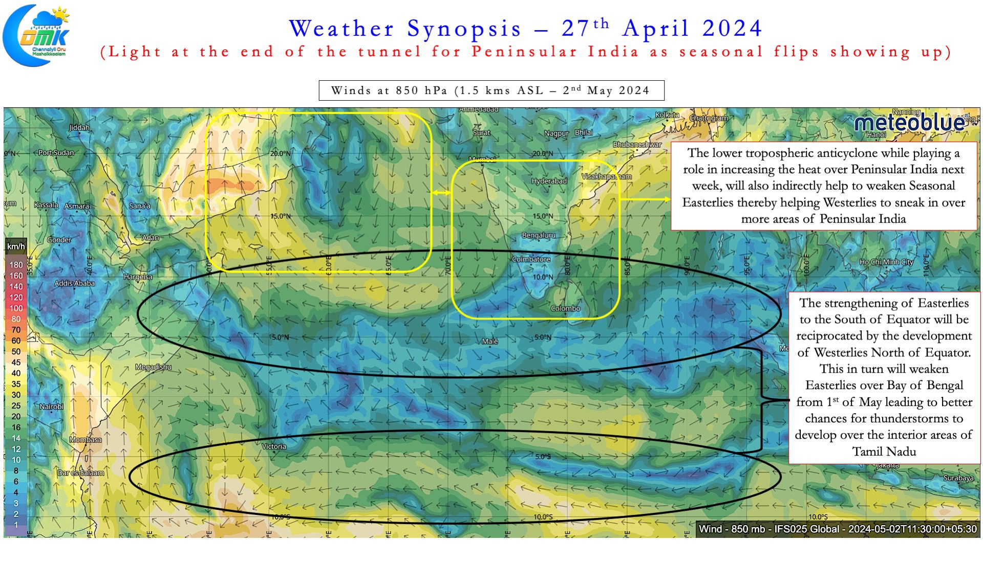
But there is always light at the end of the tunnel. As we grit out the upcoming heatwave, there are indications nature is also churning things to favour us as well. A lower tropospheric anti cyclone is expected to bring the heat over Peninsular India. But it is also likely to bring an unintended benefit, weaken the Easterlies, to allow Westerlies to sneak into Peninsular India. As we all know when the winds start to make that seasonal shift, Veppasalanam thunderstorms are not far away. The baking hot conditions we may experience the upcoming week will set the perfect platform for thunderstorms to derive a lot of convective energy.
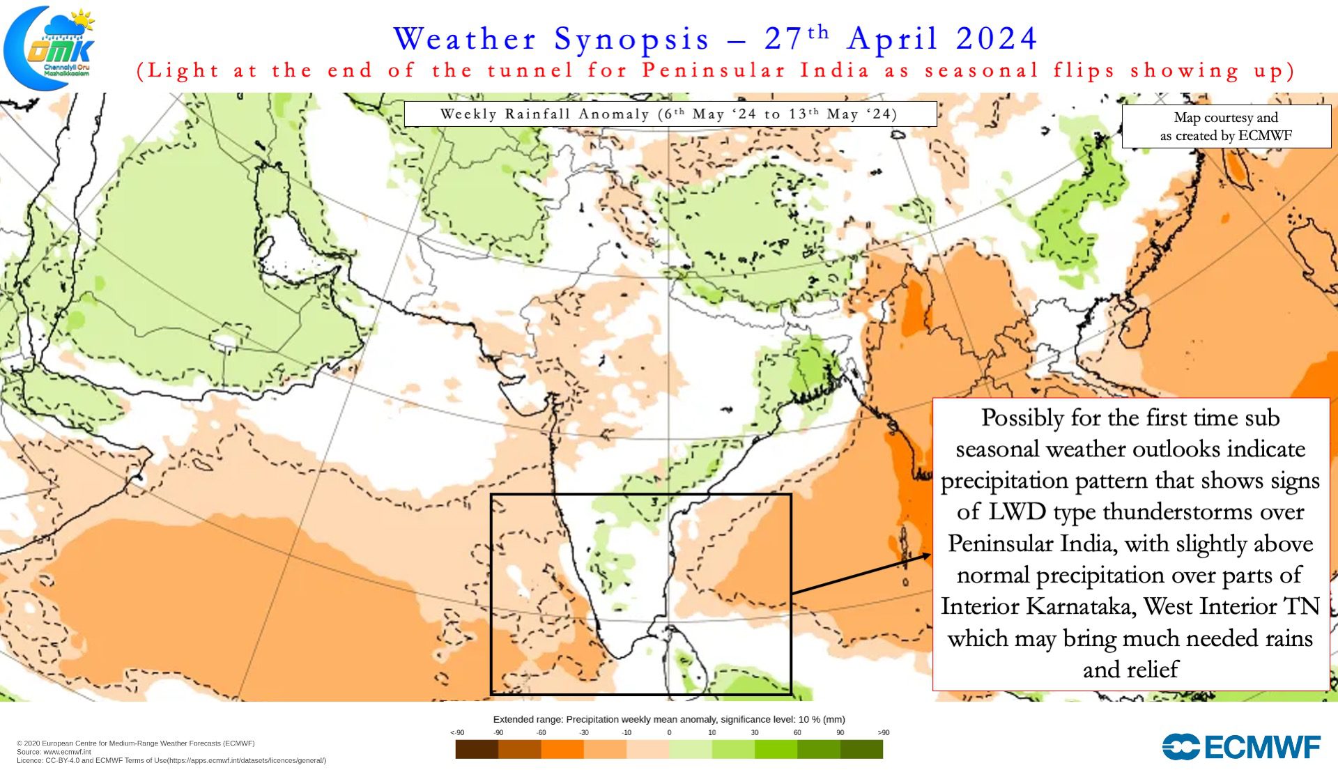
West Interior TN and parts of NW Interior TN and adjoining areas of S Karnataka who owe a lot of their annual rainfall quota to transition thunderstorms can look forward to some help from nature. As the Easterlies weaken from around 5th May these places can see thunderstorms on a more regular basis. It is important to point out unlike monsoon rains these are not going to happening on a daily basis. Certainly there will be enough rains to not only cool down the parched soil but also gradually improve soil moisture. The arrival of summer thunderstorm season merits a dedicated post which will be put up in due course.
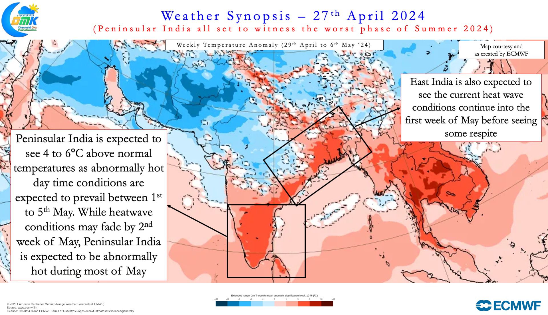
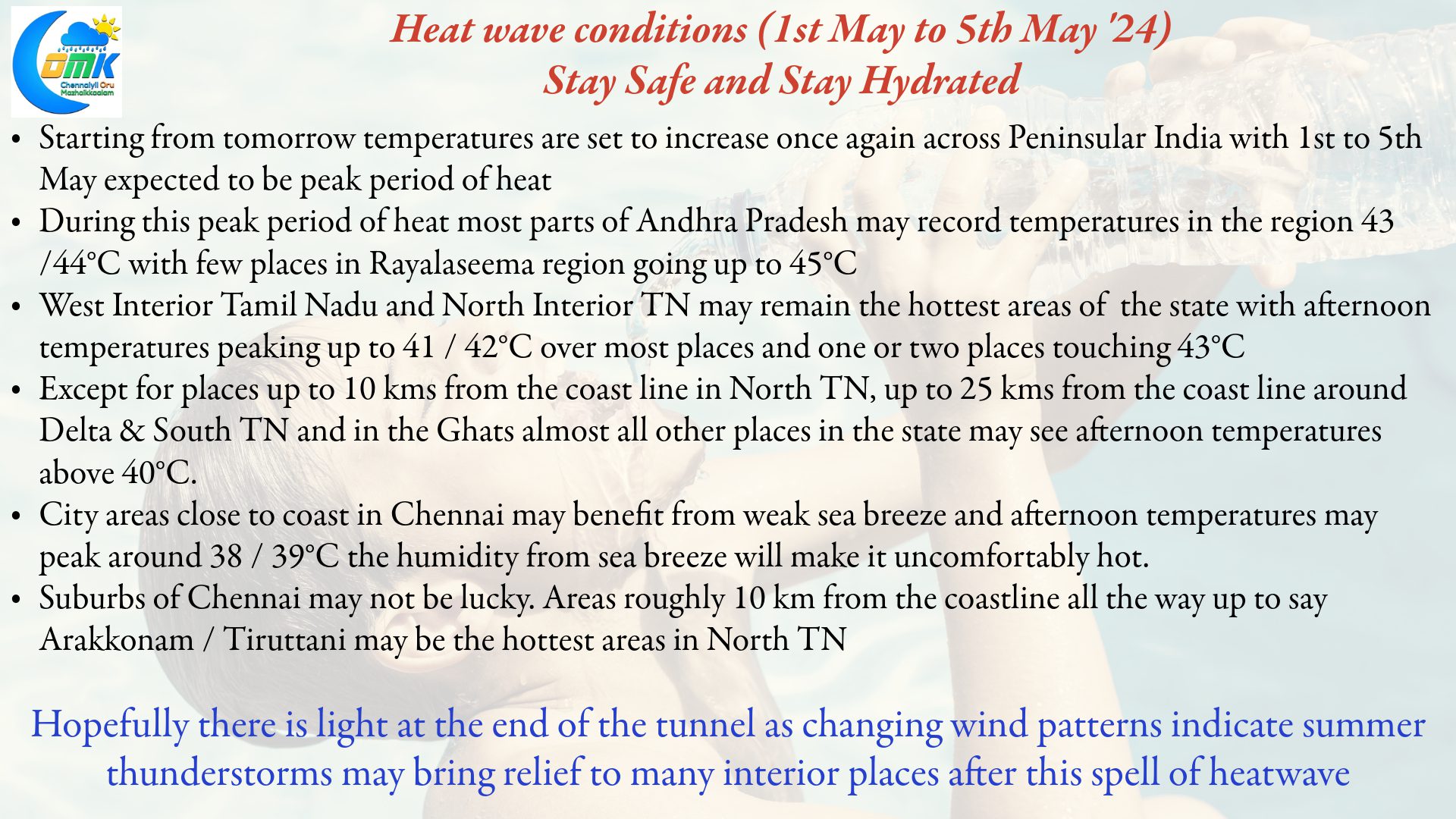
Before that we have a small matter of “Peak Summer” next week. Weather models indicate Peninsular India is likely to be the hottest part of Indian Sub continent once again next week. While the model forecast of 46°C over parts of AP may not happen. There is a good chance many places in AP may see 44 / 45°C between 30th April and 4th May. This period will also coincide with heatwave conditions over Tamil Nadu. West and NW Interior Tamil Nadu is likely to be the hottest part of the state. Many places in these regions may see peak temperatures between 41 and 43°C during this period.
While areas along the coast in Chennai may benefit from weak sea breeze during the afternoon the western suburbs are unlikely to benefit form it. Areas roughly 10 km from the coastline all the way up to say Arakkonam / Tiruttani may be the hottest areas in North TN. Between 1st and 4th May places in these areas could see peak temperatures of around 41 / 42°C. Isolated places may touch 43°C though it remains to be seen if they are recorded either by the observatories or AWS network of IMD.
To sum up. Another line from the song shared above ஒரு வாசல் மூடி மறுவாசல் வைப்பான் இறைவன். Stay Safe Stay Hydrated.