
Relay
a : a supply (as of horses) arranged beforehand for successive relief
b : a number of persons who relieve others in some work
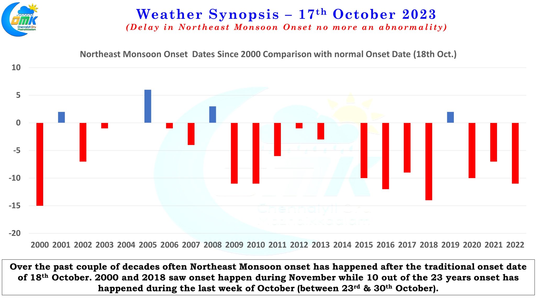
The traditional date for Southwest Monsoon to complete its withdrawal over the Indian Sub-Continent is 15th of October while the traditional onset date for Northeast Monsoon is 18th of October with a standard deviation as listed by IMD of +/- 8 days. But on many occasions the transition between Southwest Monsoon and Northeast Monsoon happens like a relay race one handing over the baton to the other. Certain years there is a gap between the complete withdrawal of Southwest Monsoon and the onset of Northeast Monsoon. 2022 saw Southwest Monsoon complete its withdrawal over the Indian sub continent by 23rd October while the onset of Northeast Monsoon happened only on 29th October.
IMD has indicated Southwest Monsoon is expected to complete its withdrawal over the remaining parts of the Indian Subcontinent in a day or two. Satellite image does indicate except for Peninsular India and some areas which is currently under the influence of a Western Disturbance most of the Indian Sub continent is under dry conditions effectively indicating the withdrawal of Southwest Monsoon. A close look at the the weather charts provide a clue on a possible delay in the onset of Northeast Monsoon over Peninsular India. We had briefly touched on the possibility of dual circulation during the 2nd half of October in our Northeast Monsoon 2023 outlook post a few days back. Now there is more consistency among the weather models of two circulations developing on either side of Peninsular India.
The first one over the Arabian sea is expected to become a Low Pressure Area today gradually intensifying as it moves further WNW. Ensembles are fairly confident of this one eventually becoming a marginal cyclone. Considering how on most occasions weather models under estimate the intensity of cyclones over Arabian Sea there is a fair possibility this could become a Severe Cyclonic Storm. The other circulation which is currently seen as a broad area of disturbance over South Bay is likely to deepen into a cyclonic circulation over the next couple of days potentially becoming a Low Pressure area towards the weekend.
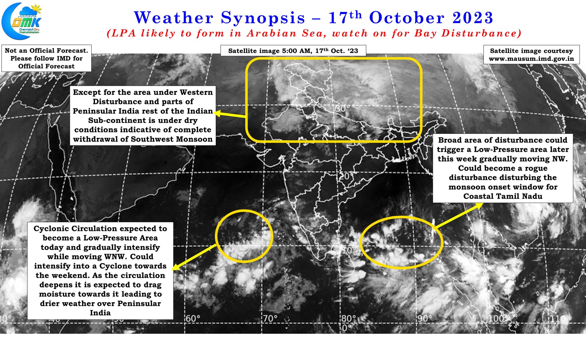
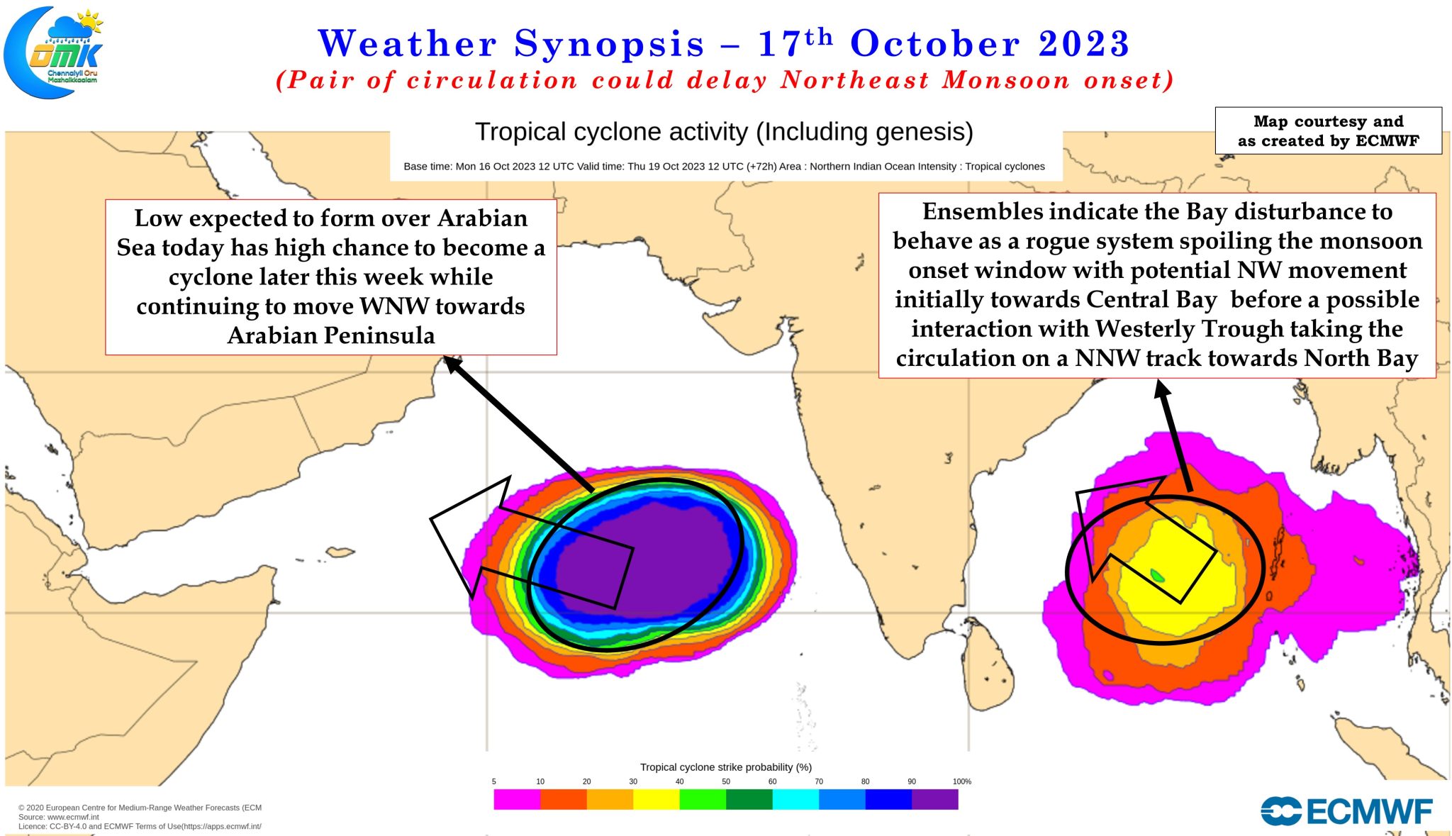
Most ensembles are leaning towards this circulation taking a more NW track towards Central Bay as it intensifies into a possible Depression. With potentially an interaction between Mid Latitude Westerly Trough and the circulation we are looking at a scenario of this circulation moving up towards North Bay under the influence of the MLSWT. If this interaction happens then we can assume with fair degree of certainty the bay circulation could show rogue behavior disturbing the potential onset window for Northeast Monsoon by disturbing the flow of Easterly winds into Peninsular India.
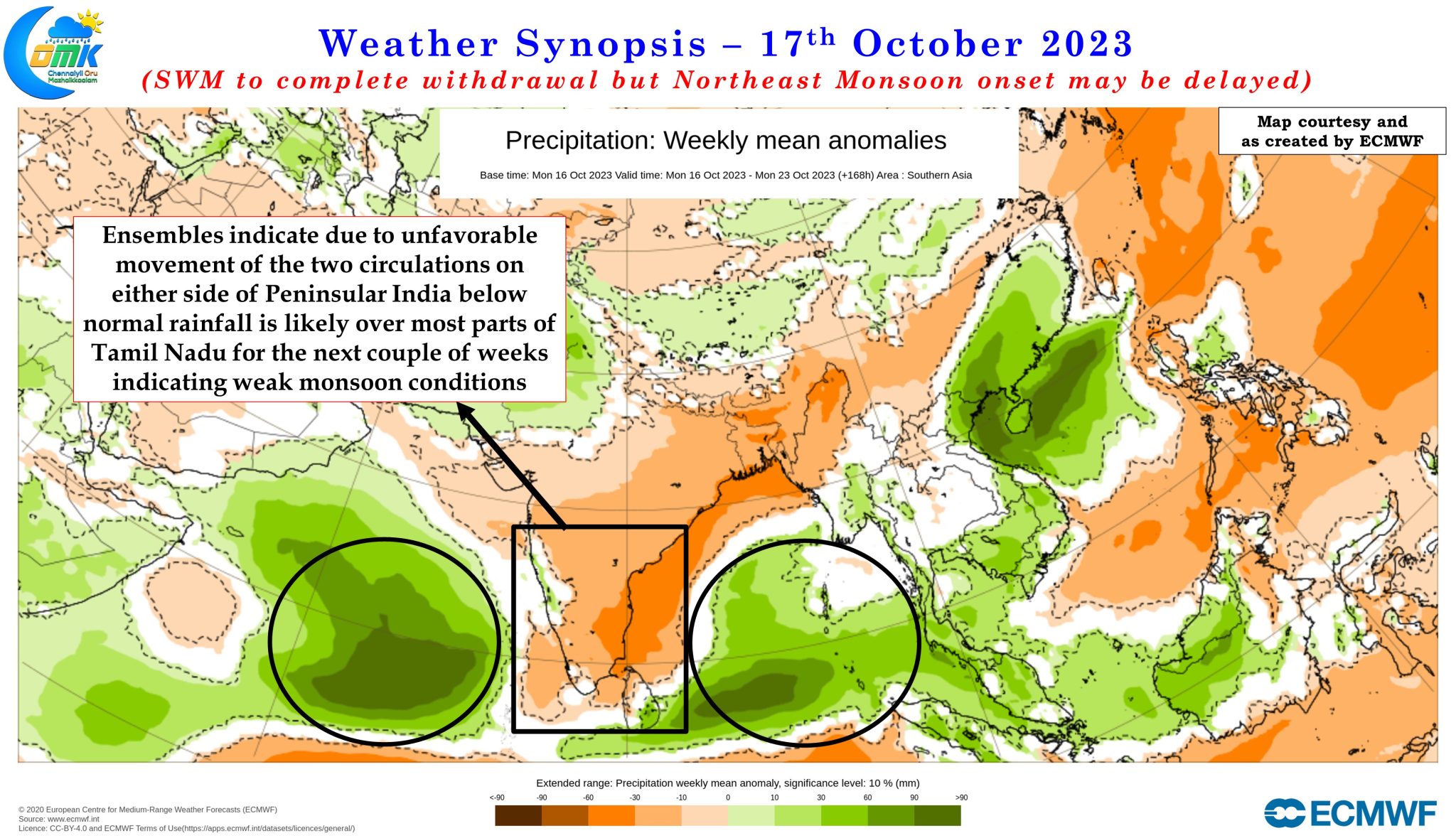
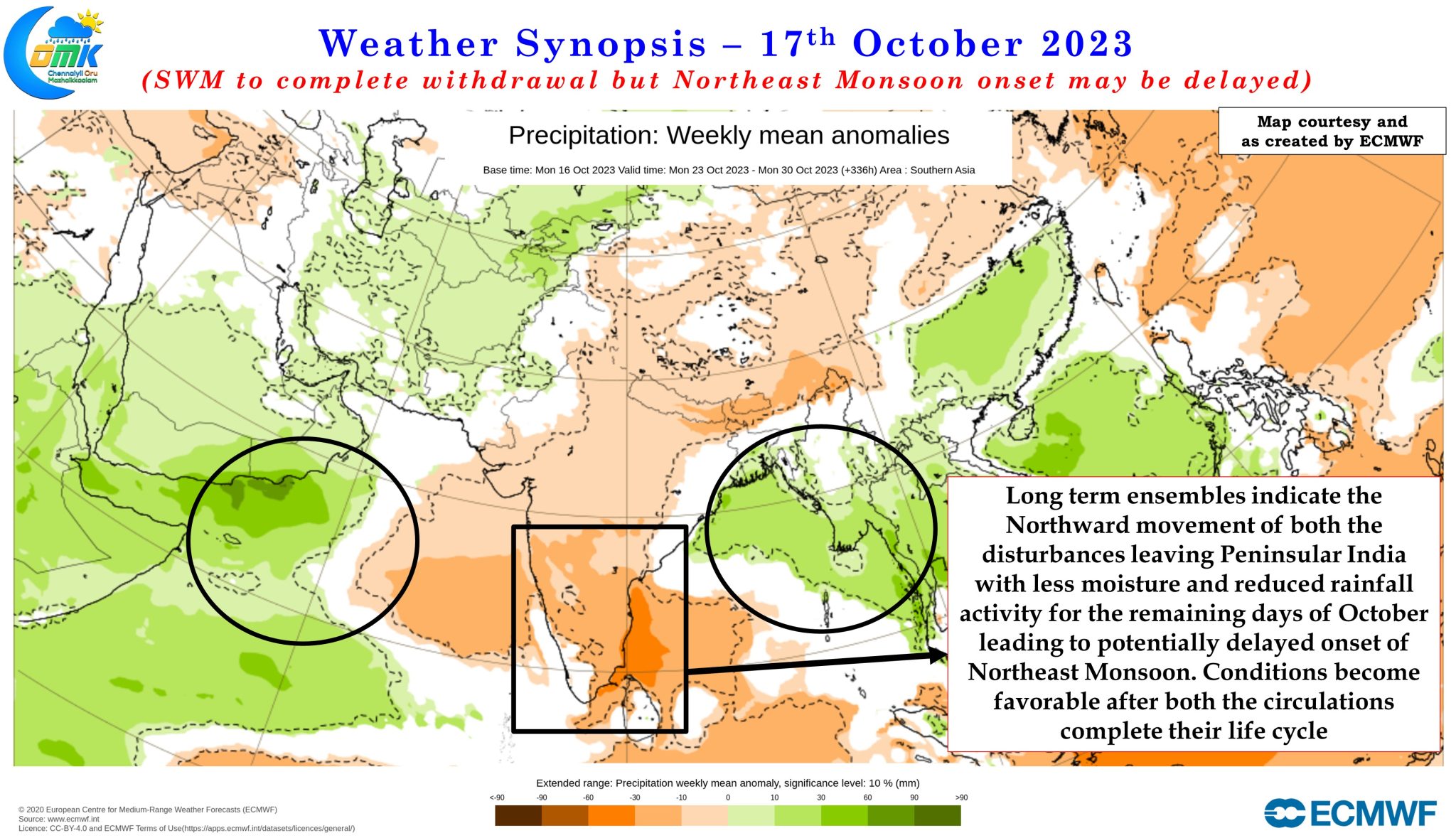
Long term ensemble rainfall anomaly charts also confirm the scenario with below normal rains over Peninsular India for the remaining days of October. As both the circulation deepens the will gradually drag the moisture towards them leaving drier conditions over Peninsular India and a reduction in rainfall. Once the circulations complete the life cycle it might be a few days before we could see the winds align favorably once again bringing back the rains over Peninsular India. While it is not alarm bells yet, a scenario where 2023 may be closer to 2000 which saw the most delayed Northeast Monsoon onset happening on 2nd November. A closer look at the onset dates does indicate delayed onset is not an abnormality any more with 10 out of the 23 years since 2000 seeing NEM onset happening between 23rd and 30th October.
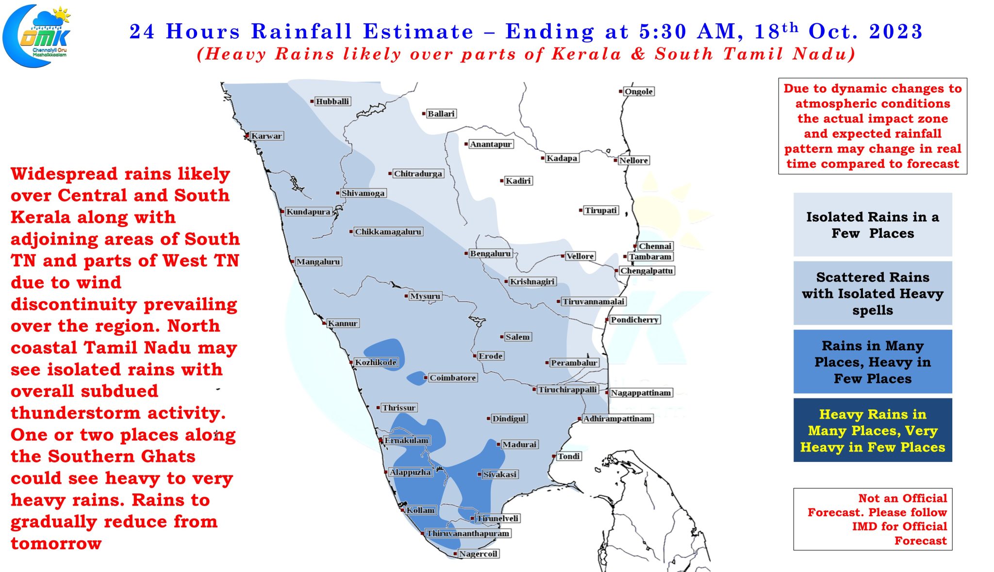
In the meanwhile today and tomorrow rains are likely to continue over West Interior Tamil Nadu and South TN before gradually reducing as the circulation in Arabian Sea deepens pulling the moisture towards it. Today we could see many places in South TN come under heavy rains with one or two places in the Southern Ghats likely to see heavy to very heavy rains. Chennai and rest of North may see very less rainfall activity with drier conditions firming up in the coming days.