
Over the last few days there has been a lot of messages on when the COMK outlook will be released for NEM 2020. What most did not realize or possibly accept was the Outlook Video released on 16th October did provide a peek into what could be expected though it was done on a light hearted way.
The key takeaways of the Outlook provided a couple of weeks back were as following
- Putting NEM 2020 Outlooks by blindly believing model outputs is like the famous auction scene from the movie ஊரே தெரிஞ்சுகிட்டேன் a slapstick comedy
- NEM 2020 is going to be a 50:50 affair with fine margins between an extremely good & a rank bad Monsoon. Unfortunately this year there is going to be only black or white and no grey areas. This was indicated by the coin toss scene from the movie Shivaji the Boss
- It is because of the nature of how it could pan out there is a chance of extreme rains if conditions fall in place as indicated by the last part of the video about something special.
Today we will try to explain a bit on what to expect for NEM 2020 as things stand. At the outset lets make one thing clear it is going to be a Nervous Wait for NEM 2020 let us not have any second thoughts about it. It has been mentioned many a times MJO is one of the key factors of the success of Northeast Monsoon considering the short monsoon period & the MJO movement pattern across the globe. The difference between 2015 & 2016 can be summarized to how MJO behaved in these two years during October to December.

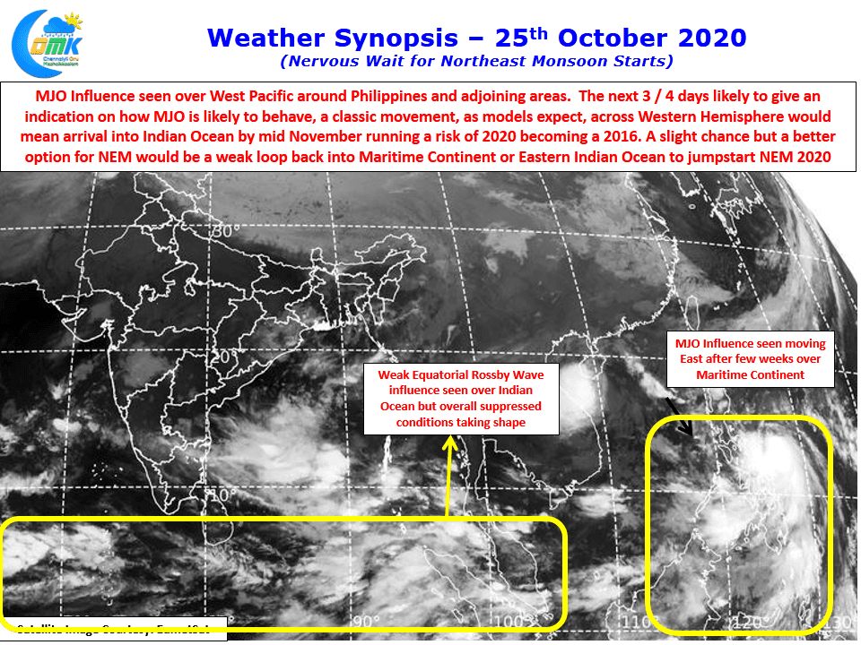
This year MJO has spent a lot of time between September & October over the Maritime Continent leading to the constant arrival of pulses into Bay of Bengal from South China Sea leading to the delayed withdrawal of Southwest Monsoon. Currently MJO is over West Pacific and most models indicate it to move across Western Hemisphere & come into Indian Ocean from the West around mid November. But models have not been able to pick this transit correctly since the start of SWM 2020 so it is still a question mark on whether MJO will actually make a transit around the globe.
But there is one other slight possibility of MJO behaving similar to how it behaved earlier in the year making a jump back into Indian Ocean / Maritime Continent without making a classic movement into Western Hemisphere. Though this could mean a low amplitude arrival of MJO into Indian Ocean / Maritime Continent nevertheless that would be sufficient enough to jumpstart NEM 2020.
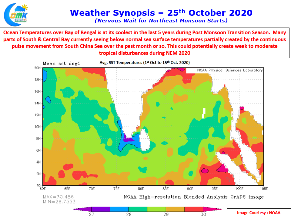
This brings us to the second part of today’s inference. Ocean atmospheres are a key part of the NEM equation due to the strong link Monsoon performance has with Post Monsoon Cyclones. Cyclones are a case of hit or miss on account of global factors like Ocean Heat which has a role to play in intensity and track altering semi permanent features like Sub Tropical Ridges. Looking at the average Ocean temperatures around Bay of Bengal & Arabian Sea it is at its coolest for the past 5 years or so during the period October 1st to October 15th.
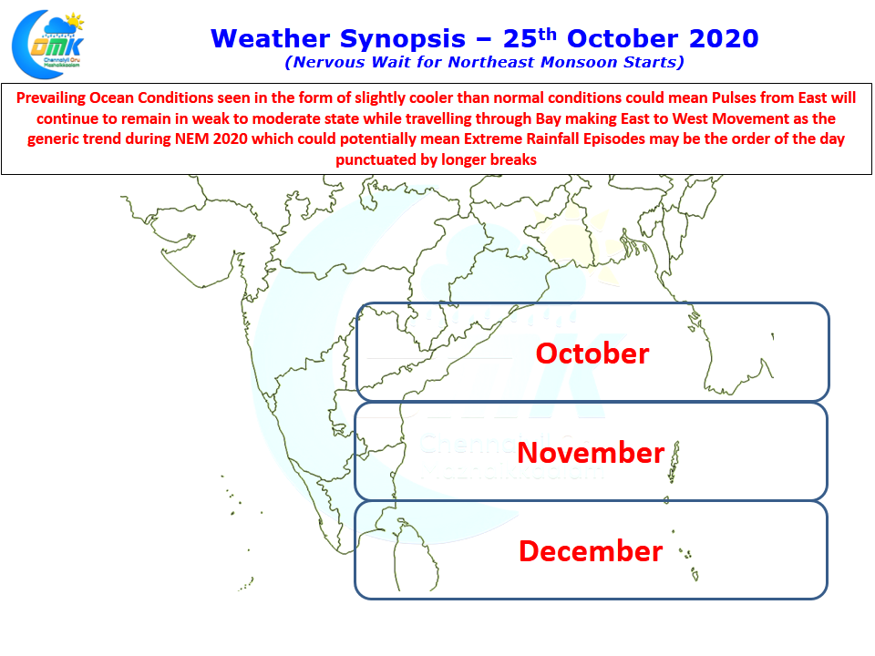
While this certainly does not mean strong cyclones can be completely ruled out, we can assume the generic trend could be weak to moderate systems may be the order of the day during post monsoon season. With weak to moderate systems we can expect a more East to West track rather than the NE recurves which La Nina years are known for. September & early October gave an indication on this type of movement pattern with near continuous pulses coming into Bay from South China Sea & most moving in a W/NW direction toward Coastal AP. If MJO exhibits similar behavior of parking itself over Maritime Continent / Eastern Indian Ocean during November we can expect similar scenario unfolding over southern parts of Peninsular India with pulses moving in towards Coastal AP & Sri Lanka.
To Summarize NEM2020 is likely to keep us on tenterhooks with its False Onset / Delayed Onset etc. MJO movement still looks dicey but its arrival in November will kickstart NEM 2020 which is likely to be punctuated by extreme rainfall episodes amidst dry spells. Farmers may have to be prepared for burst of rains that may spoil months of their hard work.