

Its tough being a weather blogger during Northeast Monsoon times. More so when there is a lot of noise in the weather model outputs & the dynamics evolve at its own pace. 3 days is a long time in weather, the events around Chennai during the wee hours of 29th October proved even 3 hours could be a long time in tropical weather as areas around Mylapore / Marina saw more than 25 cms of rains fall in less than 6 hours. But if one were to think in a detached manner surely we can benefit from understanding the way model trends are developing & possibly estimate the events. This post is an attempt to provide that clarity based on our inference of what’s happening & what could happen in the days to come over the next few weeks.
Delayed withdrawal of Southwest Monsoon along with poor thunderstorms during the month of October has created a genuine fear about the prospects for Northeast Monsoon 2020. But for those who were tracking closely the trend was fairly clear by late August / early September on the transitional dynamics getting delayed this year. Similarly the subdued start to Northeast Monsoon was also a trend that was consistently being indicated by models so for a few of us amidst the cacophony of model induced chaos the objective was to identify the right trend & provide a judgement based on the understanding while remaining true to the principles of observing in a detached manner.
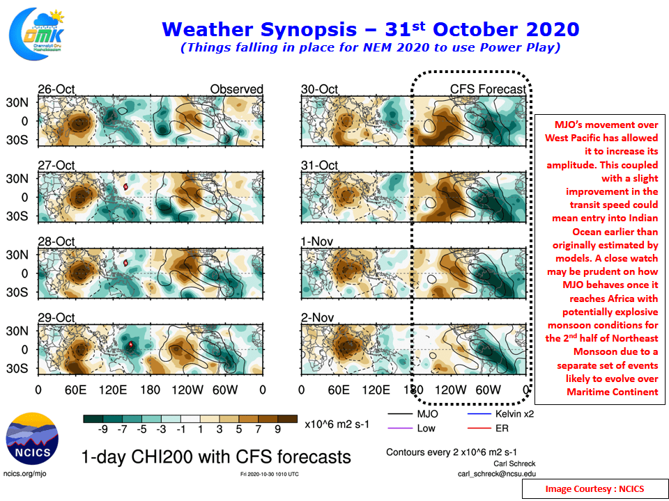
At the cost of repeating once again MJO is the Kingmaker of Northeast Monsoon almost always. A favorable transit over East Indian Ocean & Maritime Continent is the key to a successful monsoon season. After weeks of parking itself over the Maritime Continent last week saw MJO move across West Pacific whose role over the rapid intensification of Super Typhoon Goni cannot be ignored. The transit over West Pacific has also allowed MJO to increase its amplitude along with a slight uptick in transit speed over the past couple of days. This potentially could mean the rainy spell for Tamil Nadu could happen slightly earlier to what was originally estimated say a week or 10 days back. The arrival of CCKW is possibly indicative of this subtle shift in dynamics.
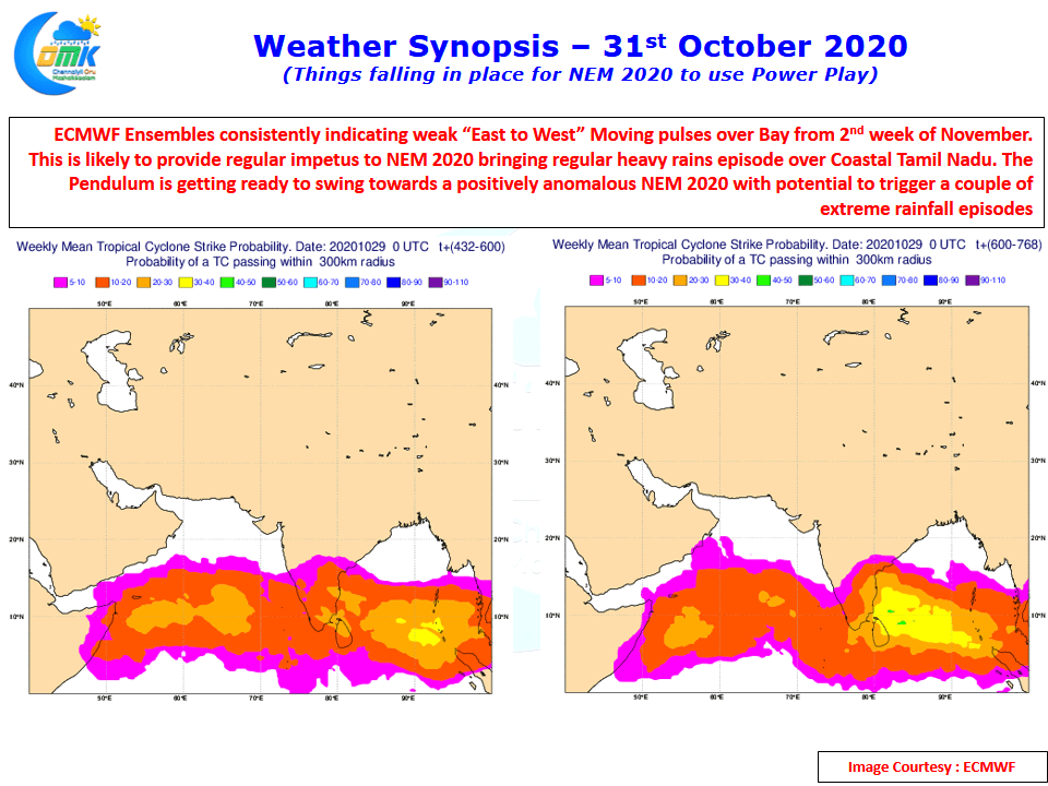
A separate set of dynamics that is likely to happen to the East of Indian Sub Continent also is worthy of mention here. Without sounding too complicated a possible situation that could potentially stall MJO’s Eastward movement beyond Maritime Continent cannot be ruled out during the second half of NEM 2020. This is also supported if one looks at the Cyclone Probability chart by ECMWF Ensembles which show similar potential to create a repeat of events that happened during the fag end of Southwest Monsoon 2020. A train of pulses moving in from the East into Bay.
To give a cricketing analogy the power play overs, in the form of favorable conditions as mentioned above, may come at the right time for NEM 2020 to up the striking rate. This post is aimed at providing early inference based on our understanding of current Monsoon dynamics. Please note the Seasonal forecast from the official weather agency of the country IMD has called a normal monsoon for North TN & below normal monsoon for South TN.
Without sounding Cocky it may be wise for everyone to be prepared for a positive anomalous NEM 2020 that is likely to see a couple of extreme rainfall episodes over Coastal Tamil Nadu. Would NEM 2020 follow the trend of 2005, 2010 & 2015 with a Vintage Dhoni Power Play Performance? Fingers Crossed