
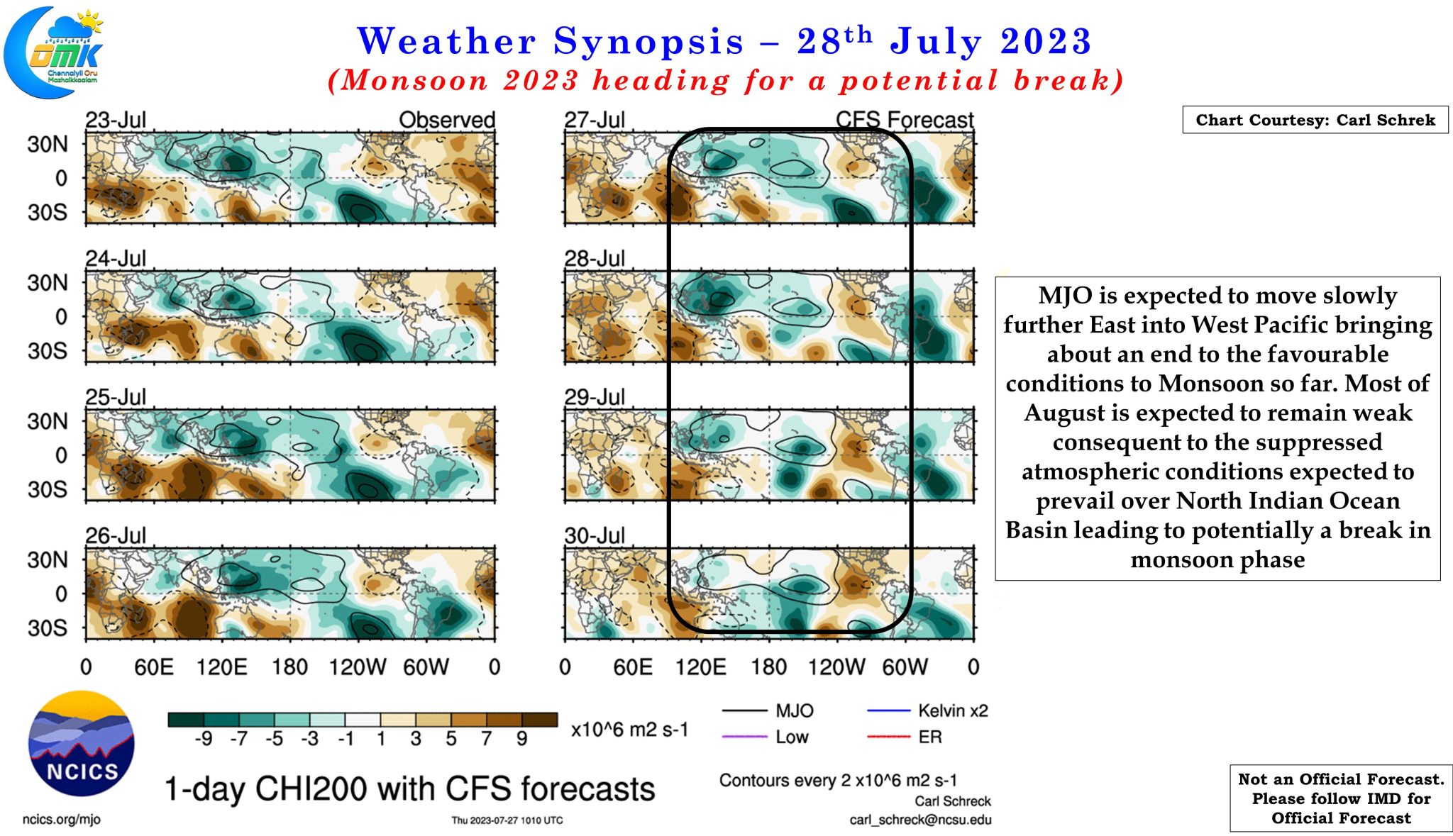
Often it is remarked while the large scale global factors play a crucial role in the overall performance of Monsoon seasons, it is important not to ignore the intra seasonal oscillations that possibly decide on the active and weak phase of Monsoon during the season. Ofcourse it goes without saying these intra seasonal oscillations owe a lot to larger factors like Tropical waves etc. MJO / MISO or BSISO as it is called among the meteorological community from rest of the world could be one of the biggest factor in theses intra seasonal oscillations.
The last few weeks have possibly seen the best phase of Southwest Monsoon this year. From about roughly -10% deficit around end July to 7% above average as on date nationally shows how the monsoon performance completely turned around. Peninsular India which was one of the worst performing homogeneous region in June with nearly 50% deficit also has turned around to 9% above average though Kerala continues to remain a worry. The key factor in this turn around was the train of favorable circulations from Bay of Bengal which kept the Monsoon trough parked south of its normal position under the influence of the stalled MJO movement over Maritime continent. The current low pressure is expected to be penultimate pulse in this train with the next one possibly developing around 1st week of August in North Bay.


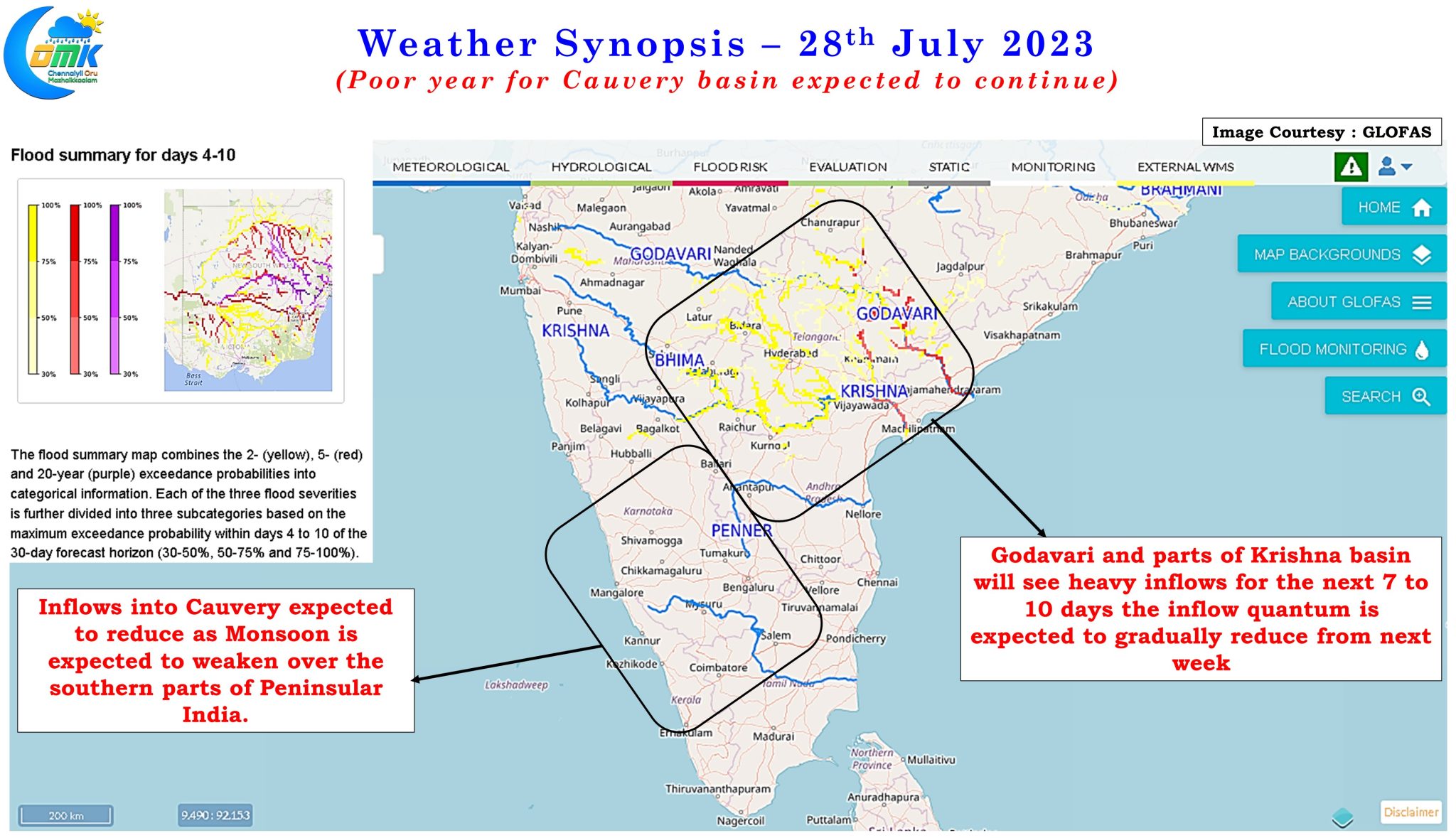
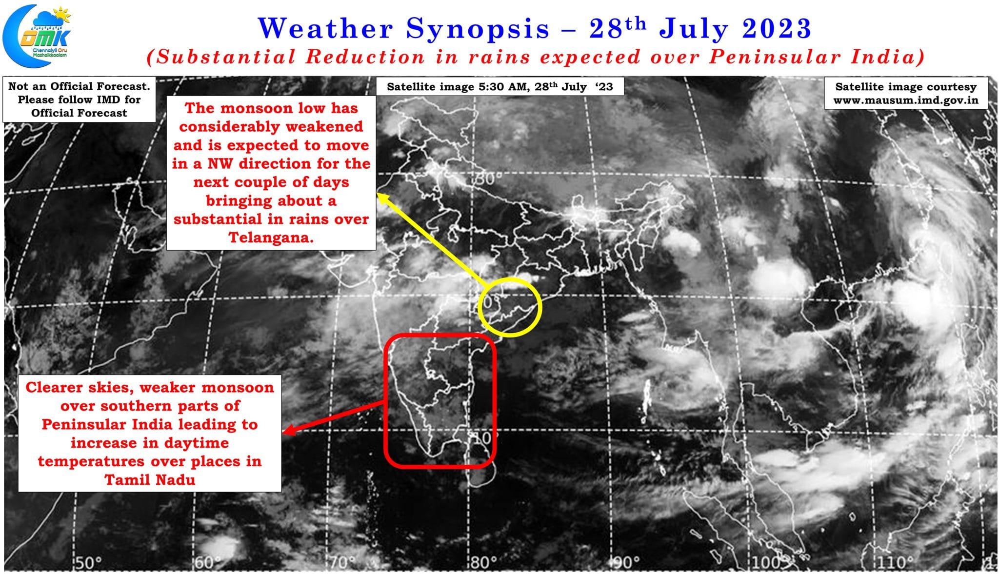
These monsoon low in a way plays a key role in modulating the up and down movement of the monsoon trough. Lows forming over North bay and moving along the Gangetic plains towards the Himalayas drag the monsoon trough North bringing about a break in monsoon conditions. Similarly during break in monsoon conditions a low pressure in Central Bay plays the role of dragging the monsoon trough south bringing about a resumption of monsoon dynamics over Peninsular India. The current set of lows all formed around Central Bay keeping the monsoon dynamics active resulting in localized flooding over parts of Telangana and surrounding areas.
MJO has now slowly started to come out of its stall over the Maritime continent and continue its Eastward journey over the West Pacific. This movement of MJO over West Pacific will bring the trailing arm of MJO over Indian Ocean leading to suppressed conditions and potentially a break in monsoon. With weather models indicating a possible low / cyclonic circulation over North Bay during first week of August traveling towards the foothills of Himalayas there is a very high possibility of monsoon going through a break after first week of August. In a way the NW movement of the current low instead of the originally anticipated WNW movement by weather models is an indication of a shift in overall dynamics influenced by the east propagating MJO pulse. In the short term this is likely to gradually reduce the inflows into Godavari and Krishna after a week to 10 days reducing the risk of further flooding.
But this is certainly not good news though for the Cauvery basin which despite the active phase during most of July got only about 60 TMC cumulative inflow with June contributing just 2 TMC overall. Though Karnataka dams in the Cauvery Basin have a fairly healthy 82 TMC storage as of yesterday a total of 40 TMC during June and July and a further 45 TMC during Augusts needs to be shared to Tamil Nadu. Given the context of poorer inflows expected in the Cauvery basin in the coming days it is going to be a challenge for the water managers of Karnataka and Tamil Nadu to effectively manage the sharing of water without antagonizing the agricultural and political stakeholders of the respective states.
The only hope though seasonal outlook of Global Flood forecast model outputs does indicate post monsoon season could give some additional inflows to bring some bit of normalcy to the seasonal inflows into Cauvery. The break in monsoon season normally coincides with an uptick in thunderstorm activity over the leeward areas of Tamil Nadu including Chennai. But it remains to be seen though if there is going to be increase in thunderstorm activity or the overall suppressed conditions over Indian Ocean play a role in subdued thunderstorms over the leeward areas of Tamil Nadu as well.