
For the spiritually inclined Hindus the mention of Dandakaranya will bring memories of the epic Ramayana where Lord Rama, Sita and Lakshmana spent a major portion of their exile period in the Dandakaranya forests. . But Dandakaranya plateau is beyond just a forest and its connection with Ramayana. Covering large parts of Chhattisgarh and some of the adjoining areas of Odisha, Maharashtra, Madhya Pradesh, Telangana and Andhra Pradesh this extremely rich region is unique in many ways. The Dandakaranya plateau play a crucial role in the sustenance of some very important rivers of Indian Sub Continent. Home to some of the oldest indigenous forest dwelling people in the Indian sub continent Chhattisgarh is very unique in having river basins of 4 major rivers of the country. Ganga, Mahanadi, Narmada and Godavari. Amarkantak hill range is an important catchment area for not only Mahanadi, the most important river of Odisha but also Son the second largest southern tributary of Ganga. Slightly to the south over the Bastar plateau, the Dandakaranya Ghats is an important source of inflows for Indravati a key tributary of Godavari. Indravati is also home to Chitrakote, the Niagara Falls of India near Jagdalpur.
Central India owes a lot of its rains during the Southwest Monsoon season to the Monsoon Depressions / LPAs that form over Bay of Bengal and travel across Central India and adjoining Peninsular India areas. As the low moves across the land it triggers heavy rains. This also explains the reason why Chhattisgarh is home to 4 major river basins. Nearly 85% of the catchment for Mahanadi river falls in the state of Chhattisgarh and to give a perspective the Mundali Barrage near Cuttact saw an inflow of more than 12 lakh cusecs during last August. At times when back to back depressions happen Central India ends up getting more than its share of rains and consequently the risk for floods increase.
Over the next couple of weeks a potential flooding episode over parts of Central India could unravel before us. Until middle of July monsoon was fairly weak over most parts of Telangana, Chhattisgarh, Odisha and Andhra Pradesh. Over the past couple of days rains have picked up due to the favorable movement of Cyclonic Circulation / Low Pressure Areas. As a matter of fact Telangana possibly received its first widespread heavy rainfall episode only this week. While one short lived low pressure area weakened and persisted as a Cyclonic Circulation over Madhya Pradesh and adjoining areas of Chhattisgarh, the next Low Pressure area is expected to form off the coast of Odisha today.
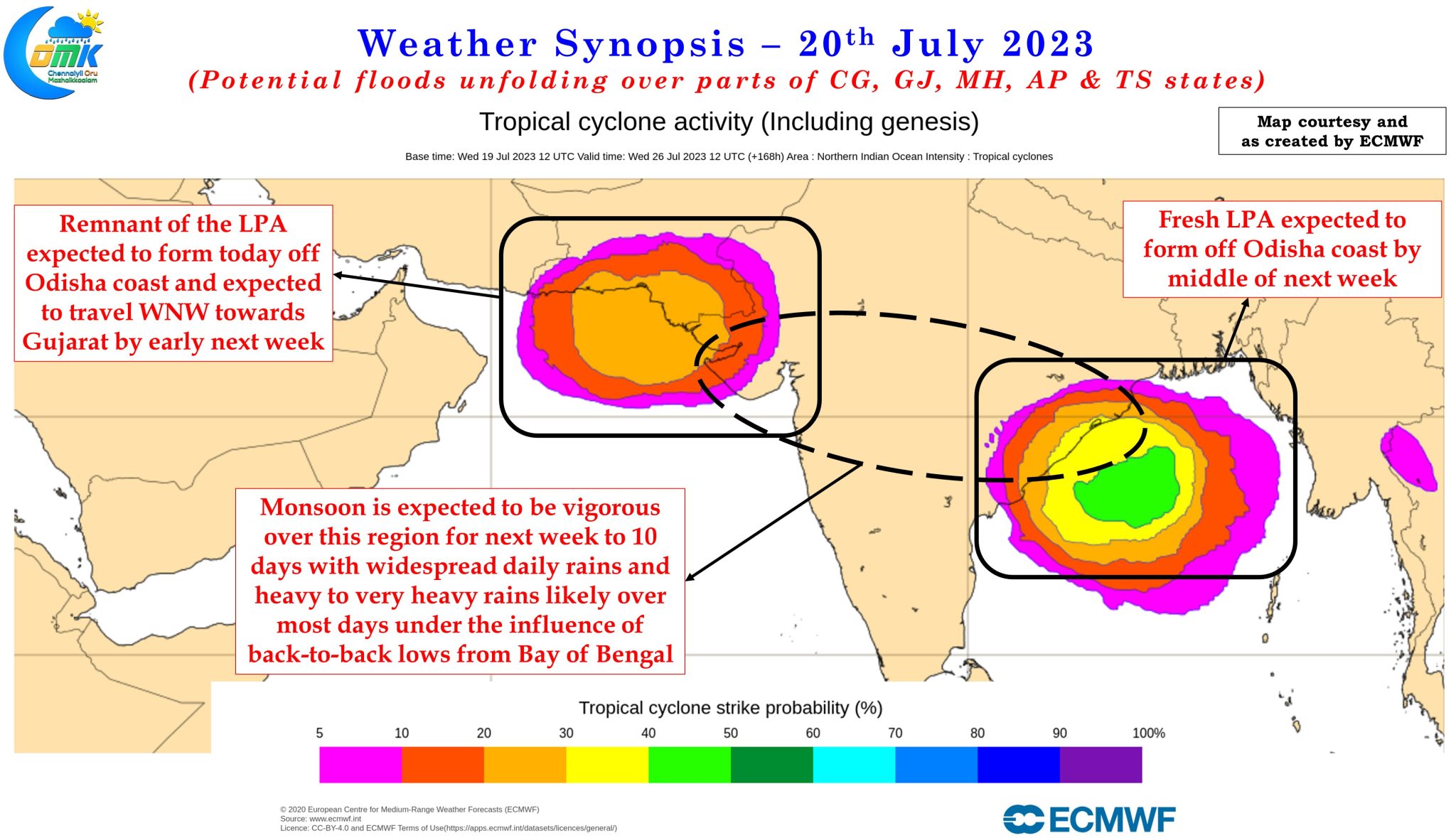
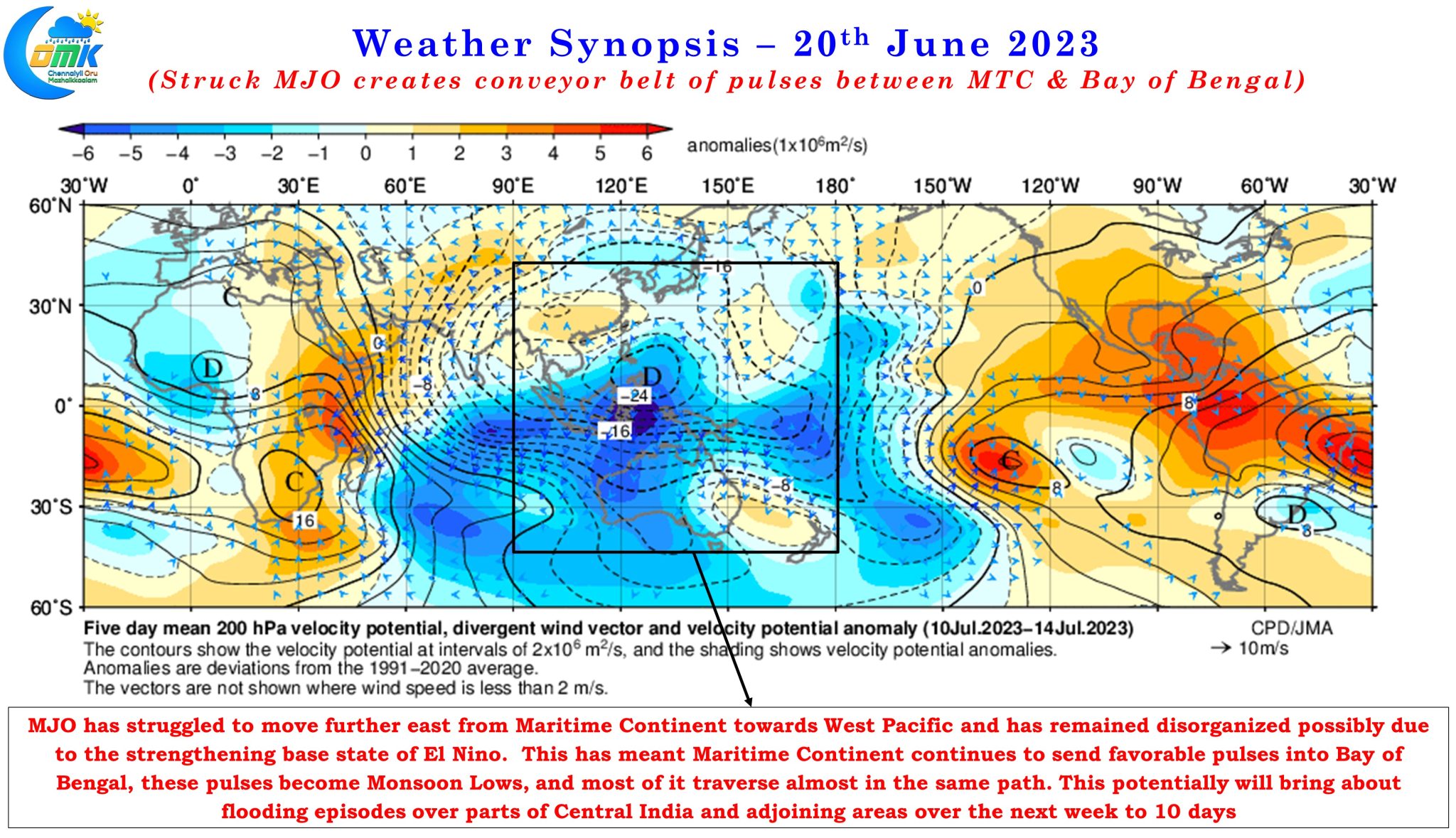
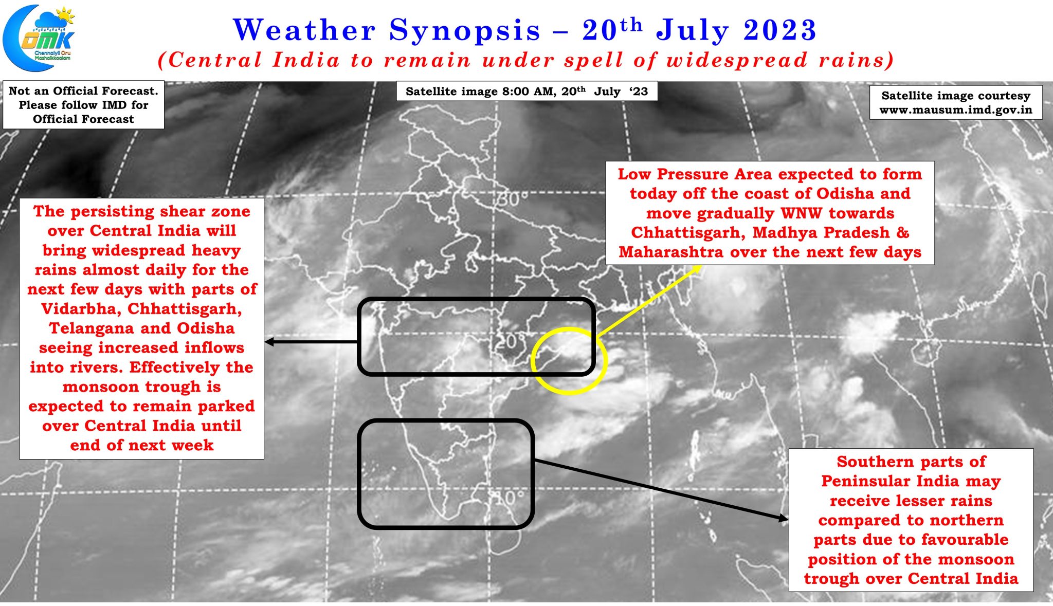
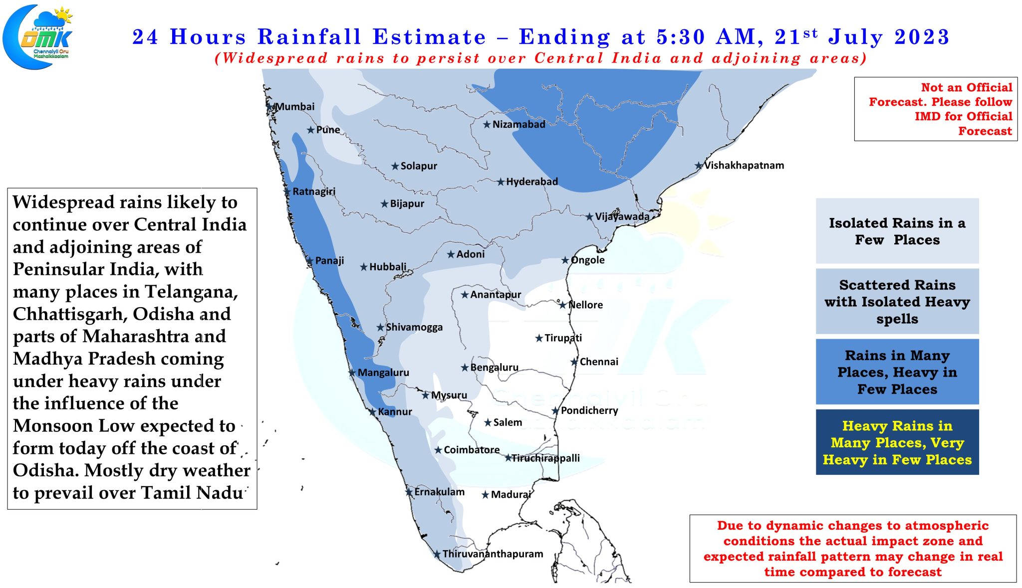
Like the earlier one this also is expected to be short lived as it moves WNW across the northern fringes of Peninsular India. As it moves across the land it will bring about conducive conditions for widespread heavy to very heavy rains to continue over Central India until early next week. Just as the remnant circulation reaches closer to Arabian Sea weather models indicate the next Low Pressure Area to form once again off the coast of Odisha and traverse in a very similar path to the earlier one bringing widespread heavy to very heavy rains once again to the same areas. One of the biggest reasons for this scenario of back to back lows is the inability of MJO to move further East into West Pacific. The strengthening base state of Nino could possibly playing a role in MJO remaining largely disorganized and influencing the tropics around Maritime Continent. This has meant a train of pulses getting pushed into Bay of Bengal from Maritime Continent something similar to the Northeast Monsoon season 2022 when a string of pulses kept NEM going with multiple episodes of heavy rains over Coastal Tamil Nadu.
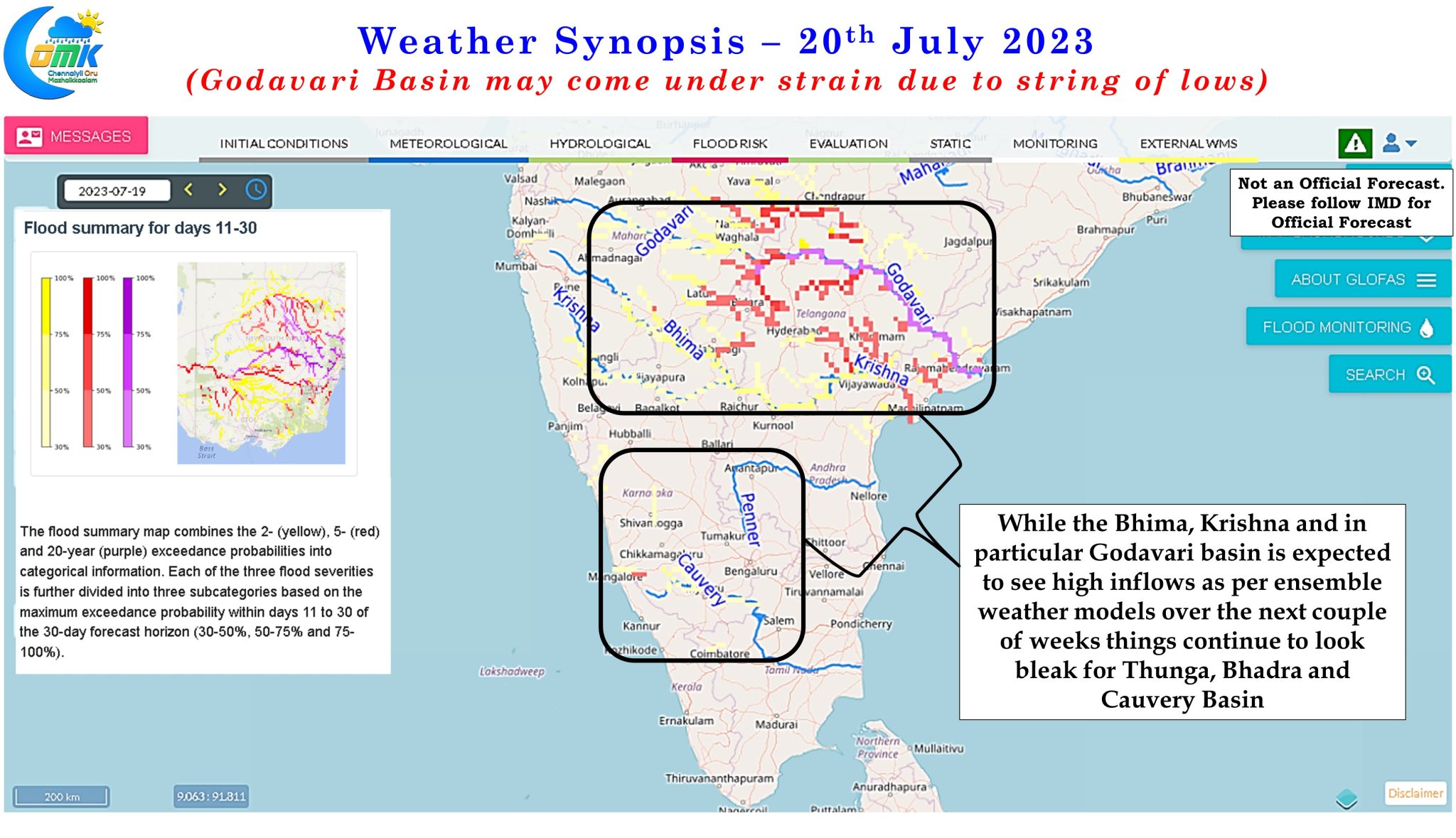
This back to back low in pretty much same path and impacting the same set of areas could potentially trigger an episode of flooding over parts of Chhattisgarh, Telangana and even parts of Maharashtra and Madhya Pradesh. Ensemble flood forecasting outputs indicate heavy inflows into Godavari basin majorly driven by inflows through Indravati. The caveat with global flood forecasting outputs is many a time inflows into rivers are controlled by Dams in India and with inter state water relationships always influenced by mutual distrust the real time inflows may or may not match model estimates.
In what could be bad news for Cauvery basin, ensemble flood forecasting outputs are not very enthusiastic over inflows into Thunga, Bhadra and Cauvery basins indicating a scenario where northern parts of Peninsular India may come under floods while southern parts of Peninsular India may not see enough rains to compensate for the poor monsoon so far.