
The Cyclone season over the North Indian Ocean has two episodes, the first one during April and May in what is effectively the pre monsoon season and subsequently between October and December which coincides with the Northeast Monsoon season and called as Post Monsoon season for better understanding. During Southwest Monsoon the presence of Tropical Easterly Jet will create high wind shear over the North Indian ocean leading to a more unfavorable environment for cyclones to develop though we have had about 55 Severe Cyclonic Storms between June and September over the past 125 years or so. June to September is more known for Monsoon depressions that typically form around the eastern end of monsoon trough and move along the monsoon trough dumping heavy rains in the process over parts of Central India and Gangetic Plain based on the track.
Weather models are consistent about a Low Pressure area developing over South bay in the next 48 hours or so. Unlike post monsoon cyclones pre Monsoon cyclones there is a certain amount of familiarity or climatology as one may call in weather terms as far as track and movement goes. If one were to look at the overall picture there are three phases almost every disturbance that forms during the months of April and May go through, first phase over the South bay which provides for a more WNW / NW movement followed by a more pronounced NW / NNW movement when it reaches Central Bay and finally a well defined North / NE recurve as it heads closer towards North Bay.
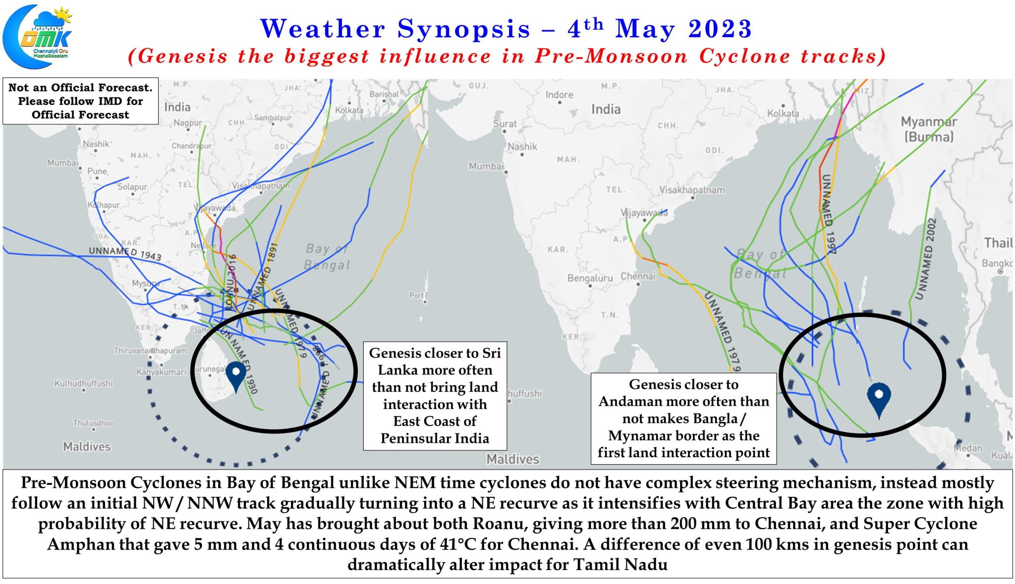
This well trodden path incidentally also provides for an interesting impact zones in terms of land interaction. Machilipatnam and adjoining areas in Andhra Pradesh is the zone which has the highest probability for land interaction along the Peninsular East Coast, one may be surprised how Odisha is not mentioned here when traditionally the coastline there bears brunt of most cyclones. During pre monsoon cyclones very rarely one gets to see direct impact over Odisha though the eventual North / NE recurve means even if a cyclone impacts AP coast around Machilipatnam they eventually track their way across Odisha bringing heavy rains. Overall though the Bangla / Myanmar stretch between Sunderbans and Irrawady delta tend to see the most amount of land interaction from cyclones during the month of May primarily due to the NE recurve in the last phase of the Cyclone cycle.
It is in this context it becomes essential to bring one very important factor in the overall scheme of things as far as cyclones during the month of May goes. “A journey of a thousand miles begins with a single step” is a common saying that originated from a Chinese proverb. The genesis holds the key of what sort of impact any pre monsoon disturbance in Bay of Bengal can make during the pre monsoon season. If one looks at the past tracks it becomes even more clearer. A genesis closer to Sri Lanka brings a brush along the Peninsular East coast for most disturbances while a genesis about 200 kms further East and closer to Andaman may make Bangla / Myanmar border as the first land interaction for the disturbance that may make the entire journey in the open waters of Bay. We have seen both Cyclone Roanu and Super Cyclone Amphan during the months of May giving contrasting weather impact to Chennai and Tamil Nadu.
While weather models are showing a south bay genesis between Andaman Islands and Sri Lanka in the next 48 hours, the initial movement is expected to be WNW / NW towards the east coast of Peninsular India over the subsequent 48 hours or so. During this phase how close the disturbance comes to the coast of Peninsular India will to a great extent depend on the actual genesis point. A drift by about 100 kms to the west compared to model estimates may bring about a much closer brush against the coast than model estimates so real time tracking will possibly give a much better inference than blindingly going by weather model outputs.
Pre Monsoon cyclones also play another vital role, in reversing the wind pattern from Easterly to Westerly while similarly the first post monsoon cyclone plays a crucial role in reversing the winds to East from West. More often than pre monsoon season tends to throw up strong cyclones, many times not picked up early by weather models, with the absence of cyclones during the preceding period providing enough energy for cyclones to intensify. Additionally North Indian Ocean starts to warm up around this period providing moisture support. Interestingly this year Bay of Bengal is not only unusually warm but also currently one of the warmest water bodies globally. This potentially is going to work like an Ace in the sleeve for the upcoming disturbance with potential for a bout of rapid intensification over Central Bay even though most weather models are not showing such a scenario.
Additionally the presence of two tropical waves, MJO & Equatorial Rossby wave, in the vicinity of North Indian Ocean brings about a complexity which weather models at times struggle against with the a further layer of a spinning counter circulation south of Equator under the influence of Equatorial Rossby wave could potentially delay movement during the first phase of the cycle.
To summarize, genesis holds the key on what kind of impact Peninsular East coast may face from the upcoming Bay disturbance an eventual North / NE recurve is more likely to happen around AP latitude. Keeping a watch on real time observations the key to monitoring this disturbance rather than go with weather models completely.