
Over the years North Indian Ocean basin has seen some of the worst cyclone related natural disasters, 1970 Bhola Cyclone that hit Bangladesh and was one of the key factors in the creation of Bangladesh as an independent country, 1991 Bangladesh Cyclone that killed nearly 1.5 lakh people. 1999 Odisha Super Cyclone which saw more than 10000 people dead as it hit the coast near Bhubaneswar. Cyclone Nargis during the year 2008 is one such cyclone which will always be high up the list of watershed moments in natural disasters over South Asia. Almost exactly 15 years back Cyclone Nargis made landfall over the Southwest coast of Myanmar on 2nd May with peak wind gusts of exceeding 200 km/h leaving more than 2.5 lakh people homeless after landfall.
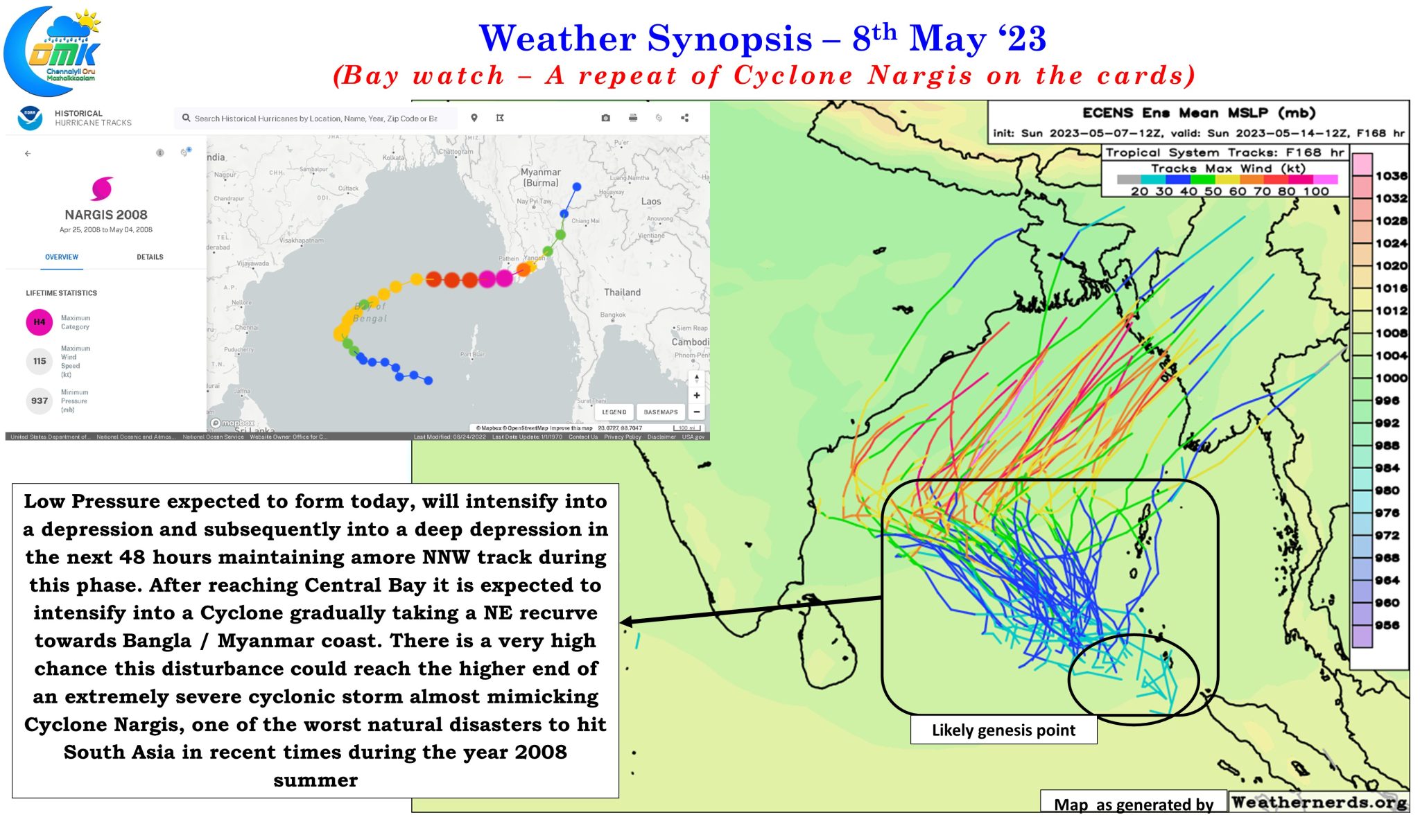
With IMD expecting a Low Pressure Area to form over South Bay and adjoining South Andaman sea today it becomes important to rewind back to Cyclone Nargis which crossed Myanmar coast with devastating effects. While the location of expected genesis of the upcoming LPA may not be exactly the same as where Cyclone Nargis originated the overall theme of development, intensification and Northeast movement towards Bangla / Myanmar coast seem to mimic Cyclone Nargis. Crucially there is one other important factor that is very similar to how current conditions are compared to the one faced by Cyclone Nargis in 2008
Researchers now believe that Nargis’ 24-hour intensification from a weak Category 1 storm to a Category 4 cyclone was due to a pre-existing, warm ocean feature in the Bay of Bengal. Here, warm, upper ocean waters extended deeper than normal, and this abnormally deep layer of warm water increased the energy available to the cyclone, fueling its growth by 300%. Similar features in the Gulf of Mexico were responsible for the rapid intensification of hurricanes Katrina and Rita in 2005.
Hurricanes Science and Study
The Bay of Bengal particularly over parts of Central Bay and adjoining North Bay, to the west of Myanmar coast, is like a tinder box boiling at nearly 32°C and nearly 3°C above normal. This is not only almost similar to the conditions Cyclone Nargis had in May 2008 but possibly warmer than 2008 as well. With MJO seen straddling Eastern edges of Indian Ocean and adjoining parts of Maritime Continent there is enough and more support for intensification of this system atmospherically in addition to the very warm ocean that is likely to provide extremely abundant moisture for the cyclone to feed on.
Weather models continue to oscillate in terms of the potential landfall zone between Sunderbans and Irrwaddy Delta but ensembles are slowly but firmly leaning towards a phase of rapid intensification in Central Bay area. The probability for the upcoming Low Pressure area to intensify into a Hurricane strength (equivalent to Very Severe Cyclonic Storm in IMD Scale) is at 50% which sort of confirms it is time to be prepared for a very strong cyclone that could potentially peak to Extremely Severe Cyclonic Storm and make landfall as a borderline Very Severe Cyclonic Storm / Extremely Severe Cyclonic Storm over the Bangla / Myanmar coast. While no two cyclones are exactly the same we have seen in the past how Phailin in 2013 almost mimicked the Odisha Super Cylone during the year 1999.
On the weather front for Tamil Nadu and Peninsular India, as the LPA develops and deepens we might see a reduction in thunderstorm activity and rains over the region starting from tomorrow. As the system intensifies potentially into a cyclone and climbs up towards Central Bay and subsequently North Bay it is expected to strengthen land winds from the West increasing the day time temperatures over the East coast of Peninsular India. Weather models indicate places like Chennai in North TN may see temperatures touch 41 / 42°C towards the end of the week or early next week.
For weather bloggers it is going to be an instance of tracking what could be a unique cyclone and another episode of learning as well.