
With the last week of May almost upon us, most of India starts looking forward to the onset of Southwest Monsoon over Kerala with more often than not monsoon already touching down over parts of Andaman & Nicobar Islands. But as is the case on most occasions Chennai sings from a different hymn sheet on weather front almost always compared to the rest of the country. Just as the rest of the country gets ready for Southwest Monsoon, Chennai and suburbs, look forward to its most active spell of summer with Westerly winds strengthening as a prelude to the arriving Monsoon over the shores of Kerala.
Earlier this month both the IMD observatories of Chennai recorded 40°C for the first time in 2023 on 14th May. The next couple of days both the stations continued to record 40°C with Nungambakkam peaking at 41.8°C and Meenambakkam peaking at 42.7°C. Ironically the 42.7°C recorded at Meenambakkam observatory 16th May remains the highest temperatures recorded among IMD observatories in Tamil Nadu and Pondicherry this year so far. It is no surprise for Chennai AP or Chennai Nungambakkam to be the hottest place in the state when Westerlies are strong. It was just after Cyclone Mocha which had strengthened the Westerly winds through its movement towards North Bay and subsequent landfall over the Myanmar coast.
The subsequent days saw winds from South / Southwest influence weather pattern over North Tamil Nadu bringing some reduction in maximum temperatures over coastal places like Chennai and suburbs. Though there was a reduction an increase in humidity during the afternoon / evening hours meant most people felt uncomfortable with real feel temperatures hovering around 45°C on most days. With Southwest Monsoon making onset over parts of A&N islands it is now time to look forward to a seasonal shift of winds to the west.
Starting today weather models indicate the strengthening of Westerly winds with models indicate a probable monsoon low over parts of Bay of Bengal and adjoining Indo China Peninsular region also playing a role in strengthening westerlies over Peninsular India in addition to improving monsoon surge over Bay of Bengal. As is the case during this time of the year clear skies during the morning hours will allow quick heating of the land thereby spiking the temperatures over Peninsular India, for coastal places like Chennai where sea breeze is a huge boon tend to go missing or remain weak under the relentless attack of the Westerlies.
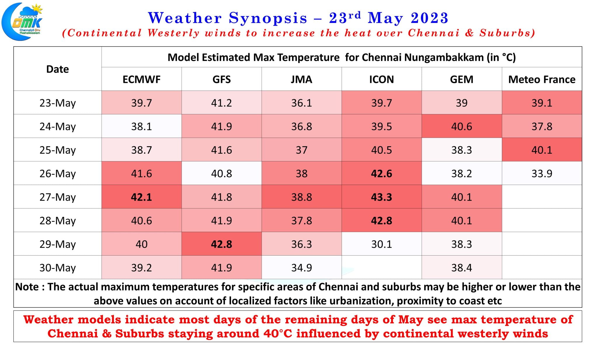
The remaining days of May promises a scenario where sea breeze could remain or in some cases go missing also until late in the evening for Chennai. Most models indicate the remaining days of May might see max temperature for Chennai and suburbs hover around 40°C with ICON pushing the max temperature for Nungambakkam to as high as 43.3°C on 27th May. ECMWF also indicates a max temperature of 42.1°C there is a very high possibility for most areas of Chennai and suburbs to record what could be the hottest day of the year around 27th May.
In the meanwhile thunderstorms are expected to continue over places closer to the Ghats for Tamil Nadu with clearer skies during the morning hours aiding the convective development. While rains at this time of the year remains low in probability for North coastal areas like Chennai nature can always surprise and that remains the only hope for some respite for the next couple of weeks as Chennai summer comes back with a vengeance.
Today’s post consciously stays away from discussing about Monsoon onset over Kerala due to lot of background noise in model estimates and a dynamic changes happening to MJO influenced BSISO movement over Indian Ocean which is essential for a clear onset. Once things clear up a detailed post on MOK will be put up.