
Oscillation
repeated movement from one position to another
Many a time it has been mentioned in this blog about how weather patterns behave like an oscillating pendulum. Intra Seasonal Oscillations are an integral part of monsoon dynamics, whether it is the Indian Summer Monsoon or Southwest Monsoon as it is called popularly, or the Northeast Monsoon. Tropical waves are the key drivers of these intra seasonal oscillations bringing along with it enhanced / suppressed phase during favorable / unfavorable phases. Southwest Monsoon 2023 in a way reflected these intra seasonal oscillations very well. Starting off poorly during the month of June, picking up pace in July under favorable conditions, subsequently going through an extremely poor phase during the month of August as MJO went into an unfavorable phase. A slog over flourish from Monsoon during the month of September brought some bit of normalcy to the overall numbers though sub divisions like Coastal Karnataka, Kerala never recovered from the poor start and an extremely bad August.
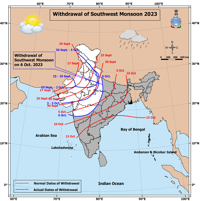
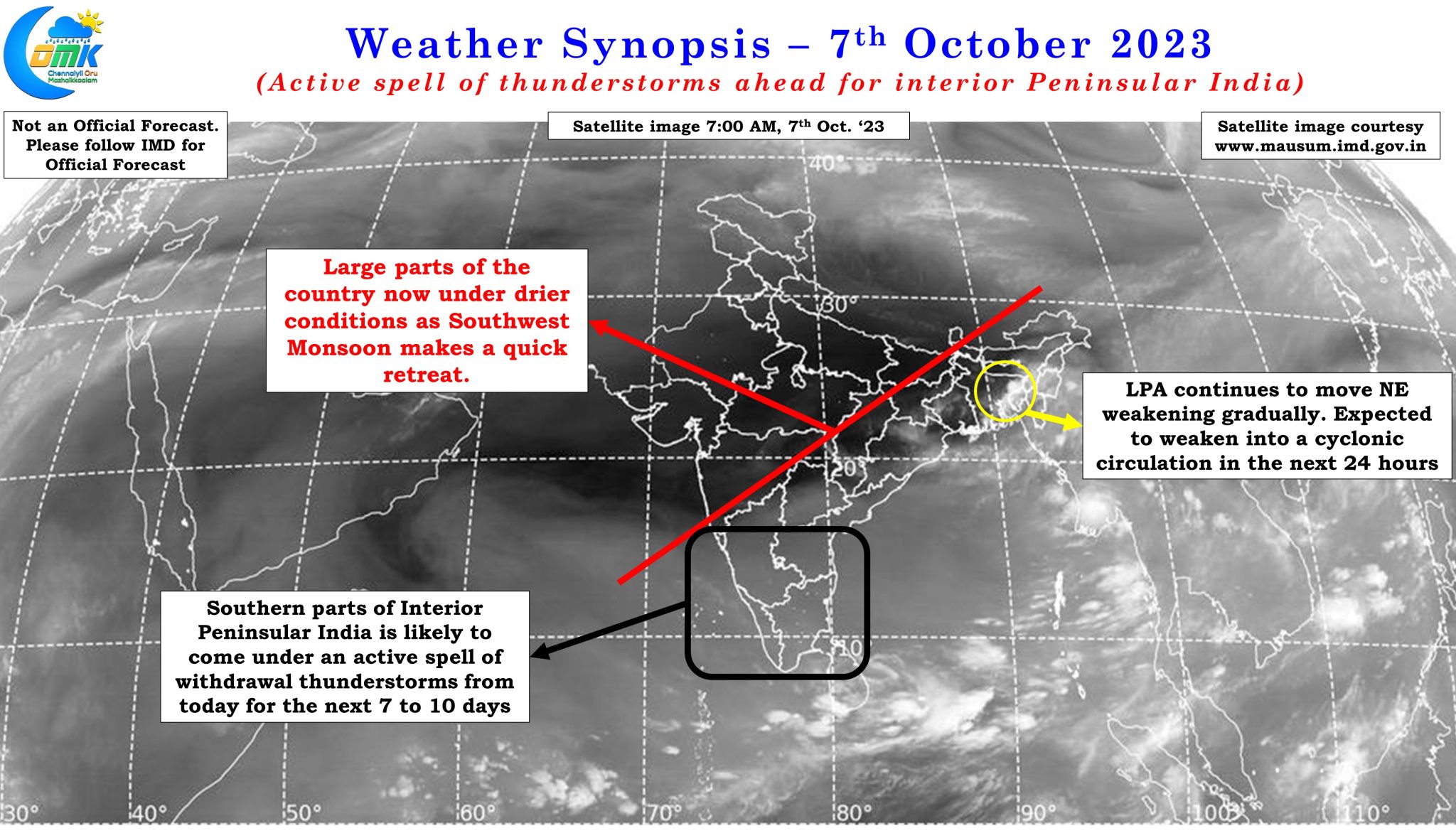
With October underway now, the pendulum has started to swing back towards the unfavorable phase and the rapid retreat of Southwest Monsoon from North & Central India after the initial hesitancy is a confirmation of that. The satellite image indicates how large swathes of the country has been gripped by dry conditions with the Monsoon low over East India remaining as the last bastion of Monsoon dynamics. With the low expected to become less marked in the next 24 hours and possibly fade away subsequently it is only a matter of time before Southwest Monsoon makes a quick withdrawal up to the Northern parts of Peninsular India. When Southwest Monsoon makes a retreat it also brings with it a window of thunderstorms for the interior areas of Peninsular India. Places in Northwest Interior Tamil Nadu, West Interior Tamil Nadu and adjoining areas of South Interior Karnataka which typically are not the best places during both the monsoons get their best spell of rains during these transition seasons pre monsoon when Easterlies give way to Westerlies and post monsoon when Westerlies change to Easterlies.
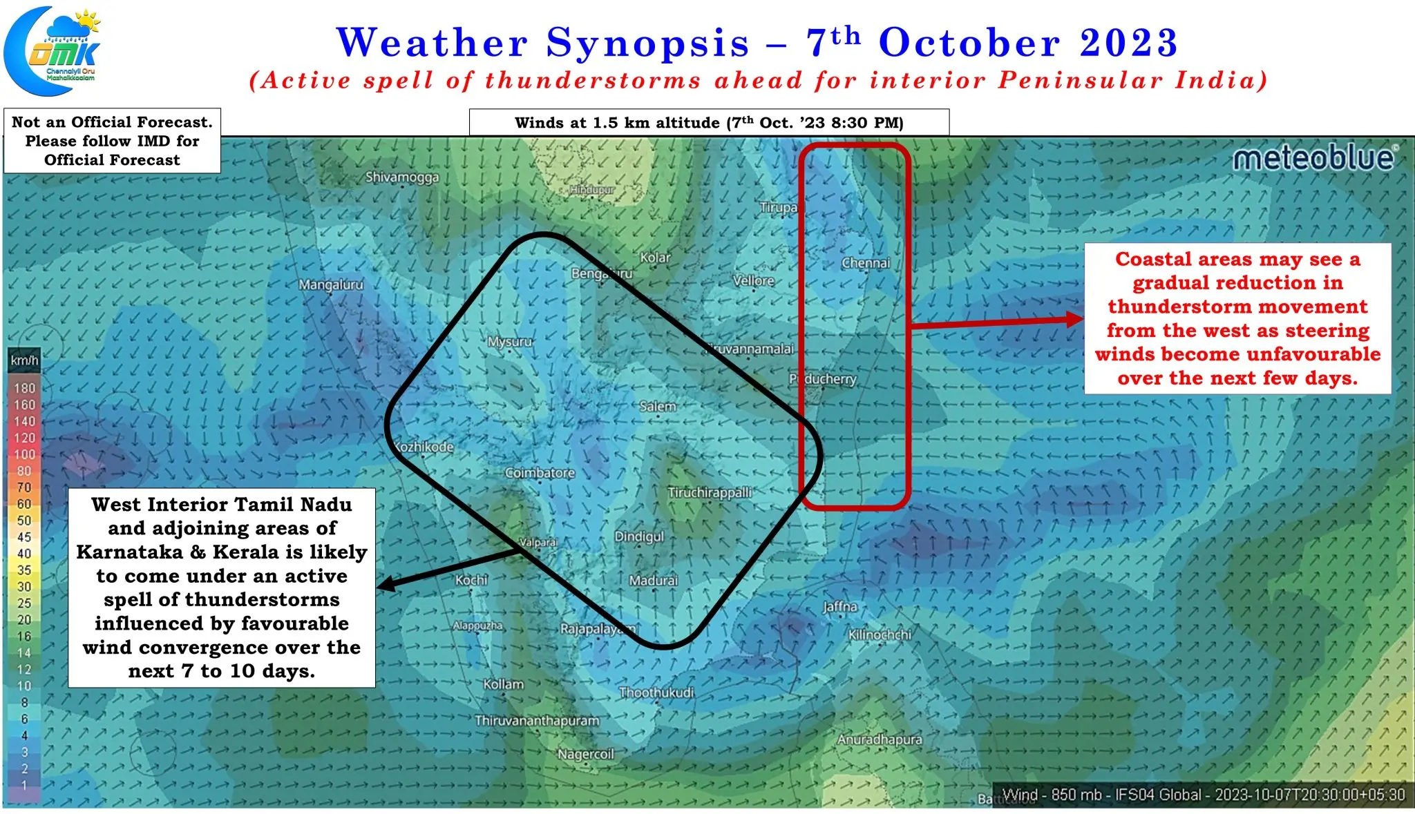
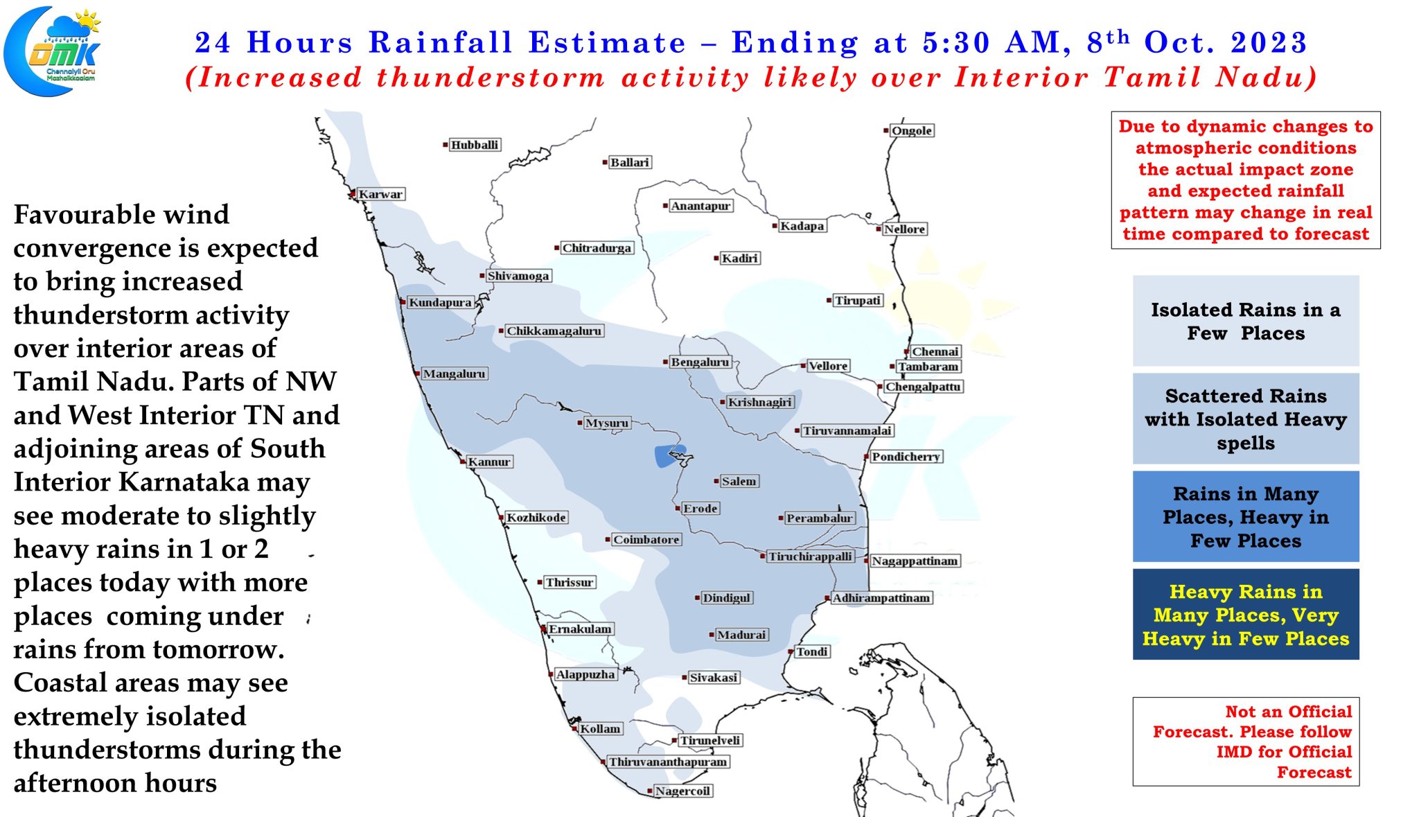
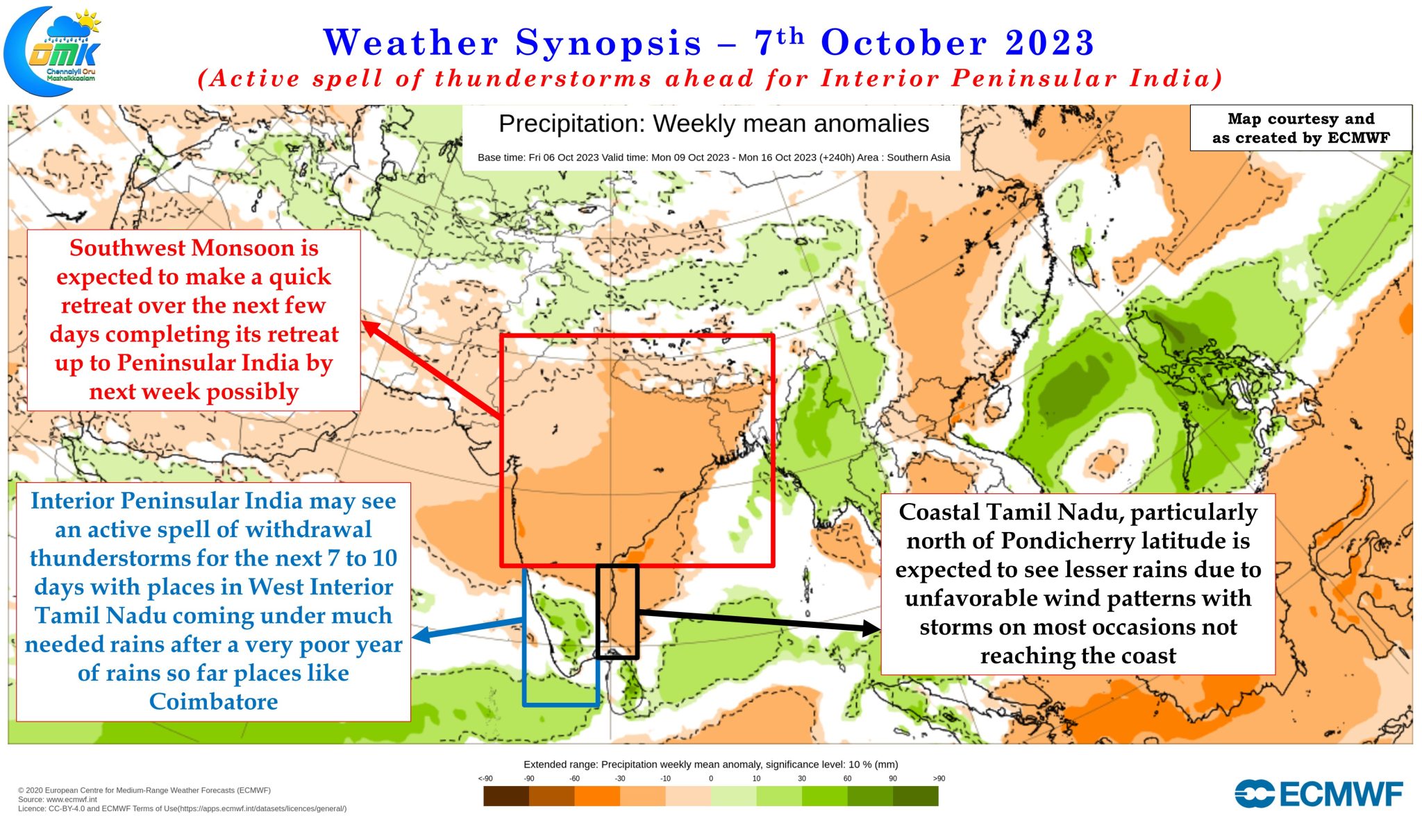
Over the next 7 to 10 days ensembles are fairly consistent about an active spell of thunderstorms for the southern parts of interior Peninsular India along with places in Kerala and Karnataka adjoining the Western Ghats. Erode, Salem, Namakkal, Dharmapuri, Krishnagiri dts along with the places dts on the leeward side of Western Ghats of dts Coimbatore, Dindigul, Madurai, Virudhunagar etc may see good rains during this phase. While the above districts are best placed for these withdrawal thunderstorms almost all of Tamil Nadu will see thunderstorm activity except for the coastal stretch between Pondicherry and Chennai which may come under unfavorable wind steering as the interior storms end just short of reaching the coast. While there could be isolated thunderstorms over the coastal areas during the afternoon hours these could be extremely restricted in terms of spatial spread with practically no movement so dont be surprised to see rains in one part of Chennai while few streets away it is bright and sunny.
Some of you may wonder on why there is still no talk of Northeast Monsoon 2023 yet. As indicated in the opening paragraph in all probability October is expected to be mostly sub par on account of MJO, currently straddling the dateline boundary, heading into Western Hemisphere making both the Indian Ocean and adjoining areas of Maritime Continent not conducive for widespread rainfall activity. This is bound to reflect on the potential onset window for Northeast Monsoon though Southwest Monsoon may exit quickly in the next few days.
Until there is a reasonable amount of clarity on the “Oscillation” and when the “Pendulum” is expected to start its journey back to a favorable position it is academic to discuss about the prospects of Northeast Monsoon 2023.