
The earth is unique in many ways among the planets of solar system. If one were to look at the two planets on either side of Earth in the solar system, Venus & Mars, the two have contrasting surface temperatures with Venus averaging 464°C while Mars averages -65°C as mean temperature. It is this balance that Earth strikes making it the best suited planet among the solar system for human habitation though there are other factors as well that make most of the planets uninhabitable. Similarly the atmosphere is full of such balanced dynamics at various scales & levels bringing forth variations in weather pattern when the pendulum oscillates ever so slightly.
The seasonal oscillation of the pendulum between Easterlies & Westerlies create large scale dynamics to trigger Northeast and Southwest Monsoon respectively. While the interlude of Sun and Wind not only creates monsoon in the larger scale subtle changes at a much smaller scale also brings about a change in temperature pattern shifting the heat from one part of the country to another. The role of Northwesterly winds over North TN during summer is well known to coincide with what may be the hottest phase of Chennai summer.
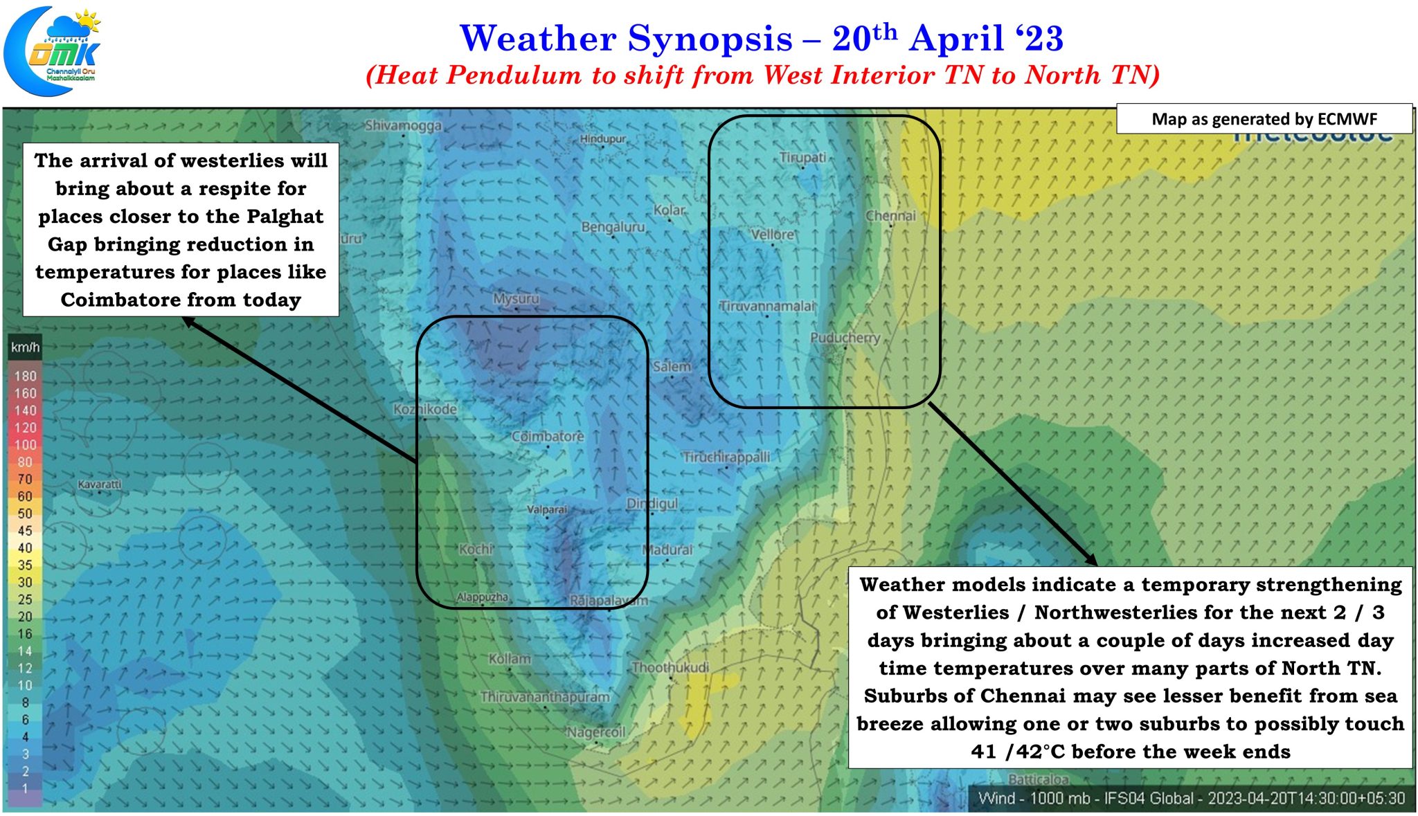
So far in this journey of Summer 2023 the bulk of the heat quotient in Tamil Nadu has been seen over West interior Tamil Nadu with places like Erode and Karur Paramathi being the IMD stations to record 41°C or more. The biggest factor in West interior TN seeing the bulk of the heat was the prevalence of Easterly winds from the land that enhanced the day time heat over these areas. Not only west interior TN, places to the west of Palghat Gap in Kerala also saw very hot day time conditions for the past couple of weeks. There is nothing abnormal about the heat though as these areas see their hottest time of the year when the winds from the East are at their strongest during March / April.
All this is expected to change though, at least on a temporary scale, with winds expected to change from East to West over Tamil Nadu shifting the pendulum of heat over places closer to the East coast for the next 2 / 3 days. This is also likely to coincide with the gradual return of thunderstorms through wind instability over places along the Western Ghats and west coast from today. In a way thunderstorms will provide further respite from heat for the places closer to the Ghats which were reeling under high day time temperatures for the past couple of weeks.
With the temporary strengthening of westerlies and weather models indicating even a bit of winds from NW for parts of North Tamil Nadu there is a fair possibility of one or two suburbs of Chennai particularly over Tiruvallur district to record 41 / 42°C in the next 2 / 3 days before temperatures drop down due to combination of changing winds and thunderstorms that could result in near normal or slightly below normal temperature during most of next week across Tamil Nadu.