
Have you ever wondered if one can anticipate and predict the genesis, intensity and tracks of tropical disturbances almost weeks/month in advance with reasonable confidence?
While prima-facie, we believed MJO to be the sole tropical wave driving all monsoons, ER which has always been present along with MJO and which moves east->west has actually been the silent driver of the winter monsoon/NEM. In the excitement of tracking MJO, we have collectively failed to spot this mother wave of the Northeast monsoon.
“Any year, that has seen normal to excessive NEM rainfall, you will see an active ER and a passive weak to moderate MJO (irrespective of whether it loops in our basin or follows a canonical propagation). In other years where NEM has performed deficient to normal, you will see ER has been either less frequent/weak irrespective of the amplitude of the MJO.”
In the last post, an intriguing question was posed: “We know the Southern Indian Ocean also has monsoon dynamics though not to the scale of the Indian Monsoon. Both Australia as well as Madagascar have their monsoon seasons run through December – April.
While Australia located to the east is majorly driven by seasonal migration of ITCZ and land-sea pressure gradient setup similar to SWM, Madagascar located to the west is heavily dependent on favorable tracks of tropical disturbances just like TN/PDC during NEM. You basically see large-scale dynamics of both the boreal summer (Jun-Sep) and winter monsoons (Oct-Jan) on both sides (east and west) in the South Indian Ocean during the same period of Dec-Apr.”
How can two completely different atmospheric dynamics co-occur (simultaneously happen) in the same time (December-April) when their monsoon season lasts? Why this contrast between the basins in the two hemispheres (NIO & SIO)?
Well, the technique presented in this post also holds the answer to this ‘enigma/head-scratcher’. You will find the insights somewhere around the end of this post.
The heart of this post is to understand how the tropical waves represented in the Hovmöller diagram serves the purpose of prediction of future weather events. Inadvertently, it also helped in validation/verification of this new empirical technique as OLR Hovmollers Archiveswith embedded tropical waves are available starting 1982. Before delving into the details, some recap on the identification of this technique. It is a long-pending dream for any weather enthusiast to predict genesis, track and intensity of tropical systems.
This technique sprung up in early 2024 when AI-based weather forecasting was also slowly becoming a norm. The quest to forecast disturbances beforehand emerged, and while Hovmöllers are represented typically as ensemble means of NWP outputs, it gives a new opportunity to make informed decisions without being swayed by looking at daily operational forecasts. While, intensity prediction still has other atmospheric/oceanic variables in play, this technique can aid, especially with at most certainty, with respect to genesis and track. To use this technique, one has to overlay the Hovmöllers, typically either with variables of PW or Velocity Potential for both 5-15N and 10-20N latitude plots to pinpoint the possible latitudinal intersections of the tropical waves for picking the genesis.
For assessing Tamil Nadu (TN) and South Andhra Pradesh (SAP) centric rain events, while we overlay, we have to keep eye on one more critical aspect, whether MJO influence is restricted to within 5S-10N closed equatorial bounds and whether ER influence is predominant over 5N-15N grid bound.
Genesis: The genesis happens typically at the intersection point of multiple pairs of higher frequency tropical waves and the low-frequency base state (Walker cell, source ascent) if it is present. That is either ER/MJO, ER/CCKW, MJO/CCKW, ER/MRG, MJO/Base state, ER/Base state, CCKW/Base State and its combinations.
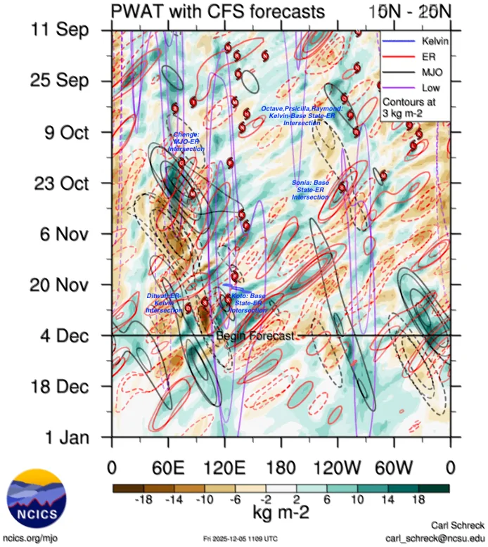
Whenever multiple options of potential genesis spot exist due to dual intersections (front and rear-end intersections) of tropical waves, one of them will likely thrive. The survival of the fittest is likely to be again decided by whether MJO/CCKW or ER/MRG is the stronger wave during the intersection. When MJO/CCKW has the upper hand, genesis is likely to get pushed to the east due to moderate to strong equatorial westerly wind burst, however, when ER/MRG emerges stronger in amplitude, genesis is likely to get pushed to the west due to moderate to strong off-equatorial easterly burst. Thus, using the Hovmöllers, we can pinpoint in advance as a possible coordinate grid box (latitude-longitude bounded region), where potential geneses are bound to happen.
Intensity: While the intensity of weather systems is heavily dependent on other factors such as Mid-layer wind shear, Ocean heat content, westerly trough interactions, dry air entrainment, we can judge to fair enough accuracy if the disturbance has the potential to intensify into a cyclonic storm by looking at the amplitude (contours of the waves in the Hovmöllers), their forecasted frequencies and durations of influence through slopes observed during their propagation. The MJO, ER, Kelvin & Base State RMM indices might be useful in this aspect. These can be tracked at the NCICS website. Typically, MJO/CCKW enhances poleward outflow while ER/MRG enhances equatorward outflow of developing tropical distrubances. Thus, using the Hovmöllers, we can judge the possible intensity scale of a weather system, however with lesser accuracy as local mesoscale features play a predominant role in their eventual attainable intensity.
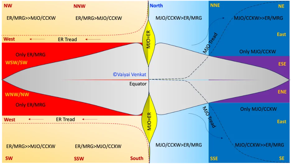
Track: The tracks of weather disturbances can be derived through analysis of the amplitude and slopes of the intersection of the tropical waves. A diagrammatic representation of the eventual tracks of systems has been provided after decoding them through a careful study using the Hovmöllers diagrams of multiple past events across the globe. This innovative diagram is a personal construction by the author and has been appended to this post. The top quadrants represent tracks in northern hemisphere while the bottom quadrants denote those in the southern hemisphere. In both the hemispheres:
Only MJO/CCKW:
- The presence of MJO or CCKW results in poleward movement of system always.
- An MJO traversal is generally preceded and succeeded by a CCKW. They bring in large-scale convective enveloped with enhanced Upper-level Divergence (ULD). CCKW can also occur independently as they are very high frequency waves (VHFW). The CCKWs have been known to interact with mid latitude troughs and cause deeper penetration into the tropics.
- In NIO, the track will be skewed almost NW to ENE depending on their amplitudes. In SIO, the track will be skewed almost SW to ESE depending on their amplitudes
- This is because it reorients the ridges meridionally and cause ridge contraction/or jet extension during their transit, affecting both the Indo-Arab & Indo-Pacific subtropical ridges in NH, Mascarene & Australian/Tasman subtropical ridges in SH when they move through P2/P3/P4/P5.
Only ER/MRG:
- Conversely, the presence of ER and MRG traversals redirects systems to take an equatorward track
- An ER traversal generally brings with it unstable weather as they enhance cyclonic vorticity, Lower-level Convergence (LLC) and thereby providing sustained favorable conditions for tropical disturbances to take shape.
- In NIO, the tracks will be skewed between SW to NW depending on how strong the amplitude of ER is, southwesterly component will be more pronounced. However generally, westward & west-southwestward path is taken.
- In SIO, the tracks will be skewed NW to SW, depending on how strong the amplitude of ER is, northwesterly component will be more pronounced. However generally, westward & west-northwestward path is taken
- This is because they reorient the aforementioned subtropical ridges zonally and cause ridge extension, thus restricting impacts from subtropical systems like mid latitude dipping troughs
Mix of All Waves:
- If the system life coincides with either/both MJO/CCKW and ER/MRG intersecting at a particular phase, the environment gets complicated.
- Depending on the actual amplitude and slopes of the respective waves and the timing of the interaction, the tracks will be somewhere between equatorward and poleward, i.e., initially NW/N track and followed by a westward/WSW turn or initially westward track and later pushing NW or N/NNE in regions north of the equator.
- A weakened system will however come under the clutches of climatological trade winds from ridges and hence take WSW/SW track during winter monsoon.
- For regions south of the equator, the laterally inverted (mirror) paths will be taken and are fit to be assumed.
While the descriptions above have been provided with Indian Ocean (IO) basin as an example, the same is consistent to other basins across the globe as well including, West/Central/East/South Pacific & the Atlantic.
Disclaimer: In case none of the discussed tropical waves are present to influence a system, once it develops, it will tread the regular Coriolis-based track, that is NW direction in NH and SW direction in SH as earth rotates anticlockwise around its own axis. Even in that, the track will get slightly skewed based on the axial tilt of the earth in between the two equinoxes:
- The time period, relative to the earth, when sun is moving from equator towards Tropic of Cancer (Mar – Sep) and its lap back, tracks will be skewed slightly to NNW in NH and WSW in SH. The northward propagation of MISO during the Indian Summer Monsoon has deep correlation with this as ITCZ typically lags the location with higher solar irradiation by about 1.5 months.
- Similarly, the time period, relative to the earth, when sun is moving from equator towards Tropic of Capricorn (Sep – Mar) and its lap back, tracks will be skewed to WNW in NH and SSW in SH.
These are background dynamics irrespective of the presence of influencing tropical waves to guide the storms! Thus, using the Hovmöllers, we can also predict the tracks of weather systems in advance once the potential genesis area has been identified.
This empirical technique has been applied and validated with multiple past tropical systems using the NCICS/CFS Hovmöllers archives and also BOM MJO RMM archives. Some of the historical systems in NIO basin where this has been tested out include: Thane, Gaja, Roanu, Vardah, Fani, Amphan, Bulbul, Kyaar, Vayu, Michuang, Shakthi, Montha, among others. This has also been vetted out with tropical disturbances across other global basins including Southern Indian Ocean, West Pacific, Atlantic to check if it is generic for all basins across the globe and the observations are in the positive. Details of validation studies will be part of a separate documentation that might be constantly updated.
“This suggests that while the west-east moving MJO catalyzes the large-scale planetary phenomena involving Monsoon Intra-seasonal Oscillation (MISO) during both boreal summer and Australian ISO during austral summer, the east-west moving ER catalyzes development of tropical disturbances. This clarifies as to why; the summer monsoons are MJO-driven due to large-scale features while the winter monsoons are ER-driven due to basically they being disturbance-driven monsoons.Unlike the Indian landmass separating NIO into Arabian Sea & Bay of Bengal, the South Indian Ocean has only vast expanse of open waters directly connecting to the Antarctic landmass; this is the reason why two completely different atmospheric dynamics co-occur (simultaneously happen) when their monsoon lasts (December-April). Primarily, MJO drives Australian monsoon while ER drives Madagascar monsoon.”
As a concluding remark: The Westward propagating ER and MRG waves are what is needed (ideally the KINGMAKERS) for Tamil Nadu and South Andhra Pradesh centric weather systems as it reinforces equatorward component in tracks of disturbances.
While CCKW pass can enhance convective activity associated with troughs, its tread could also bring in mid latitude troughs thereby resulting pronounced poleward component in tracks of disturbances.
Thus, MJO is NOT the KINGMAKER and it being passive (weak to moderate in amplitude) is highly beneficial for TN rains during their most active Northeast Monsoon Season (OND) when the state receives almost half of their annual rainfall quota!