
“Truths remain hidden for long while lies easily propagate across weeks, months or even years just like the week-lies”
There is always a necessity to unlearn and relearn as new insights emerge. It is in this context; as one reads the title, this post is likely to serve as a revelation to every weather enthusiast/blogger. The blogging community has long learnt the importance of MJO envelope in enhancing the convective activity across the equator, that it might be difficult to scrap its influence on their minds before something new is about to be fed in. In a way, we are happy to share this post at a time when a favorable transit of a strong amplitude ER wave has cast its effect and caused unstable weather over core regions of NEM in the absence of an active MJO.
A year and a half back, when curiosity struck to understand the evolution of rain waves and weather systems, it almost occurred as a sudden flash on the distinct roles of MJO/CCKW & ER/MRG during the summer and winter monsoons respectively. Let us see why MJO drives Southwest Monsoon (SWM) while ER drives Northeast Monsoon (NEM)?
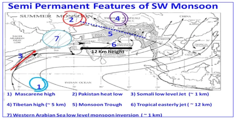
Southwest Monsoon: The key semi-permanent features of SWM is depicted as adapted from IMD forecaster’s competency document. As can be seen, Mascarene high, low level Somalia jet, establishment of heat low and tropical easterly jet are critical for ITCZ (henceforth, the axis of the monsoon trough) to firmly set up over the Indian subcontinent. Drawing concepts from enzyme catalysis: Here, the enzyme (heat low/Indian subcontinent) has an active site (monsoon axis) waiting to bind with the substrate (MISO) to react and generate products (monsoon lows/depressions that travel along the axis of the monsoon trough). However, it is imperative to point here that the energy pushed through MISO that propagates northward indirectly comes from a new convective MJO pulse that pushes eastward with a phase lag (check this NASA visualization for more details). Further, the MJO propagation and its associated westerly wind burst (WWB) excites/catalyzes the Somalia jet and hence enhances the monsoon surge since both move in the same direction (west -> east). On the other hand, CCKW traversals during boreal summer months (incl. monsoon season) typically enhance convective thunderstorms across leeward areas as it helps set up Line of Wind Discontinuity (LWD) between the north and the south Indian landmass.
During the break phases of the Indian Summer Monsoon, ER/MRG waves typically traverse from the east, and bring in anomalous easterlies by establishing temporary E-W shear zones that trigger an UAC over south Bay and enhances rainfall over break regions through speed convergence. Over time, this UAC descends down to become LPA over WC/NW bay and reactivate monsoon dynamics. In this context, ER serves to pull down the monsoon axis from the foothills and bring rainfall back to the core monsoon zones (CMZ).
In a nutshell, during SWM: Tailwind catalyzing events – MJO -> Equatorial Westerly Wind Burst, SWM -> Somalia jet -> Westerlies, pushes core convection towards foothills over time. Headwind Inhibiting events – ER and MRG -> anomalous easterlies during SWM, monsoon break regions typically get higher rains followed by a pull down of monsoon axis to CMZ.
Northeast Monsoon: The key semi-permanent features of NEM are the Siberian High, establishment of Borneo Vortex over the Indonesian archipelago, low level northeasterly surge and subtropical westerly jet in mid-high altitudes. Soon after the setup of Siberian High by end of September (see IMD Journal), the mechanism of NEM already kickstarts and the northeasterlies first arrive in the South China sea. Additionally, continental anticyclone also sets up over northwest India which pushes dry northerlies down to south. These northerlies though are bereft of moisture and typically require moist easterlies from South China sea to pick up moisture from Bay of Bengal and enhance convective activity in south peninsular India. As the ITCZ starts pushing south with the advent of Boreal winter and with the weakening of the tropical easterly jet that is prevalent during SWM, weather disturbances develop aplenty over the Indian ocean as low pressure center now shifts to the Bay of Bengal and adjoining Malay Archipelago. Borneo vortex sets up and picks the cold dry northeasterly trades and feeds the warm equatorial moisture into them.
Whenever an MJO pulse traverses across Phase 3 & 4, due to the induced anomalous westerlies, the Borneo vortex loses its influence and hence the northeasterly trades from Siberian High lose their freedom to propagate freely into the Bay of Bengal. “Typically, the Borneo vortex dominates when MJO is inactive and when ER is active, as ER significantly reinforces the vortex during its traversal and beneficially utilizes the cold surge” (check Diong et al.).
Also, the arrival of ER acts as a multiplier effect through generation of off-equatorial easterly burst (OEEB) that excites/catalyzes the Borneo Vortex and hence enhances the NE monsoon surge/extreme precipitation events since both move in the same direction (east-> west).
In a nutshell, during NEM: Tailwind catalyzing events – ER-> Off-Equatorial Easterly Wind Burst, NEM -> Siberian High -> Easterlies, causes enhanced easterly surge across core NEM regions of southeast Asia and south India. Headwind Inhibiting events – MJO and CCKW -> anomalous westerlies during NEM, NE monsoon active regions typically get lesser rains during their traversal due to far-east genesis (owing to WWB) and higher probability of poleward movements of tropical disturbances.
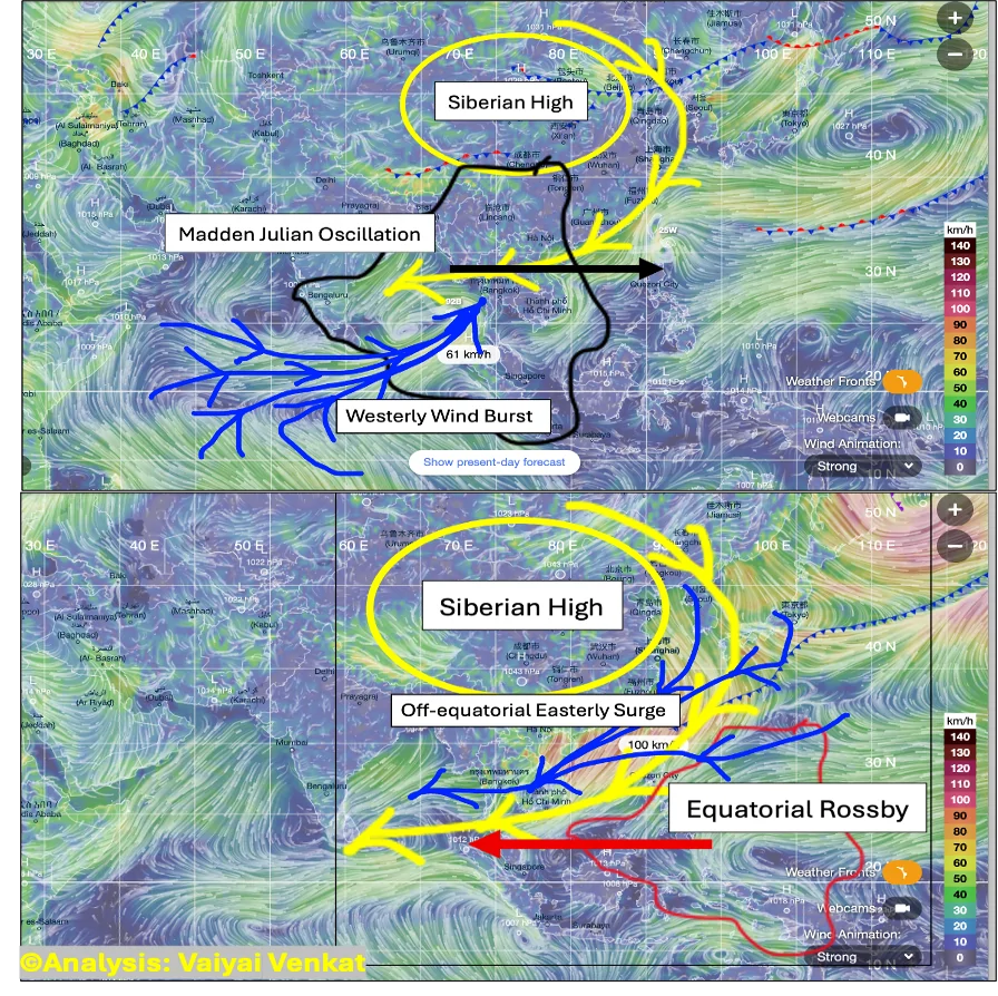
A weak to moderate MJO/CCKW amplitude with a strong ER/MRG will likely result in genesis of disturbances getting pushed more west into south and southwest Bay of Bengal and hence enhancing rainfall prospects for Tamil Nadu & Puducherry.
“A passive MJO and an active ER is always beneficial for core NEM rainfall regions”