
On 4th December when the first COMK post was made to give a brief outlook on what to expect from the Bay disturbance that now lies as a depression about 700 kms SE of Nagapattinam it talked about taking the entire life cycle into three phases. The first phase when the overall theme in terms of movement will be roughly WNW from Andaman Sea area to the Southeast Bay area gradually intensifying around this period and reaching East of Sri Lanka. The second phase of the event was when the disturbance starts taking a more pronounced NW movement as it intensifies under favorable condition. In a way today’s post sets the ball rolling for the second phase of the event. A phase when we can expect intensification from depression to Cyclonic Storm Mandous over the next 12 to 18 hours.
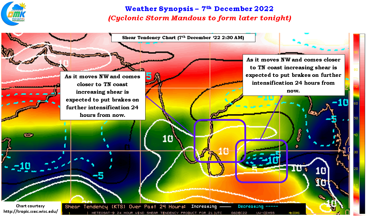
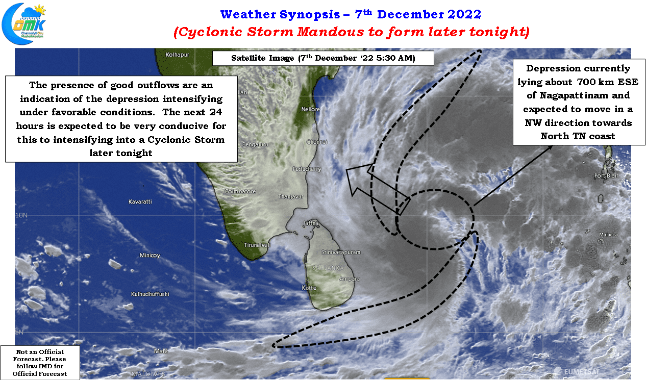
Satellite image indicates a fairly robust structure to the depression or should we call deep depression (at the time of writing the post IMD has not yet confirmed deep depression) with good outflows seen indicative of the favorable conditions prevailing over south bay. A look at the convergence and divergence charts does confirm conditions are expected to remain favorable for intensification for the next 24 hours or so. Shear charts does indicate that while currently the disturbance is in a favorable area as it moves NW towards the coast of Tamil Nadu increasing shear is expected to put a brake on the intensification sometime after 24 hours from now. While weather models indicate shear playing a role in stalling further intensification after tomorrow morning it is prudent to keep a close watch on real time basis as wind shear is a very dynamic component that has caught weather models off guard many times.
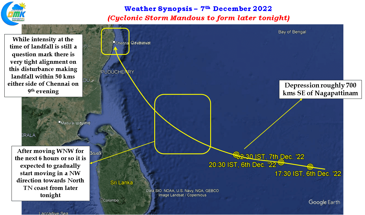
Now that Phase 1 is almost behind us and Phase 2 is underway it is also time to look closely at Phase 3 as well. There is a fairly tight alignment among ensembles and deterministic weather model outputs about Cyclonic Storm making landfall as a marginal cyclone over north coastal Tamil Nadu close to Chennai. It appears the landfall destination could be within 50 kms either side of Chennai on 9th evening. Question marks on the intensity at the time of the landfall continue to remain and will possibly be answered only in real time with a 50:50 probability of a burst of intensification closer to the coast or a sheared skeleton washing ashore near Chennai. Nevertheless there is no reason to drop guard in terms of being prepared for not only rains but also wind gusts.
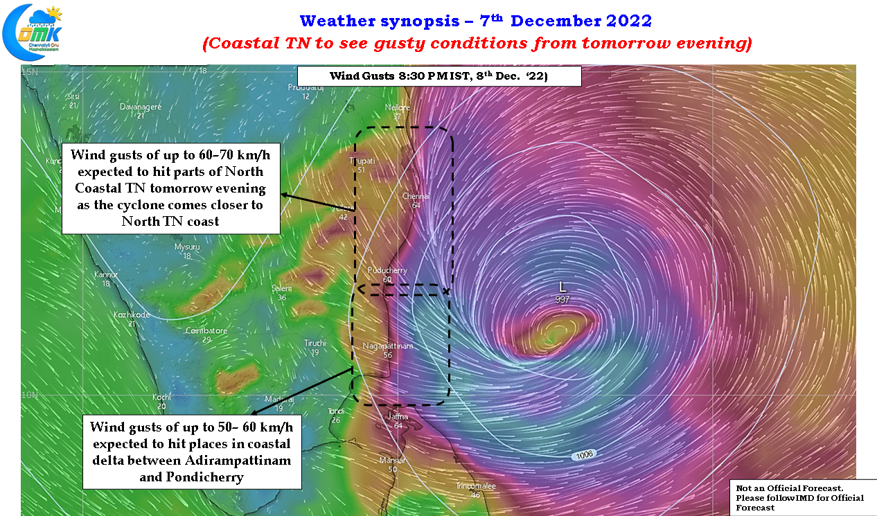
Weather models indicate wind gusts reaching up to 60-70 km/h from later tomorrow evening all along the coast from Sriharikota to delta districts while places about 50 kms or so from the coast line is expected to see wind gusts of 40-50 km/h during this period. While weather models indicate reducing wind gusts on 9th December this needs to be taken into context of the weakening trend shown by models as the cyclonic storm nears closer to the coast. Depending on the actual intensity of the system the wind gusts could increase as we get closer to landfall with north coastal TN expected to see higher wind speeds.
On the rain front today mostly it is expected to be dry across the state till later tonight with possibly delta districts the first to see rains from 96B sometime around midnight or little after that. The rest of the coast between delta and Chennai will start seeing rains gradually from tomorrow morning with increasing intensity as we get to evening. The first peak rainfall period from Cyclonic Storm Mandous is expected to be between 8th late night to 9th morning. Depending on how shear and possibly dry air influences the system as it nears the coast we will have to keep a watch on the second peak closer to landfall evening on 9th morning.