
The Boy who cried Wolf is a popular story from the Aesop’s fable talking about how a shepherd boy repeatedly fools the villagers about the arrival of a wolf and when the wolf eventually arrives the alarms of the boy is ignored by the villagers due to past experiences. The story ends with the moral Liars are not believed even when they speak the truth. One may wonder why this story when today’s post is about the upcoming disturbance in Bay of Bengal. On an average over 75% of the tornado warnings in the USA are false alarms and many times forecasters are concerned about the high amount of false alarms may lead to a complacent public reaction to alerts. Interestingly this study highlights how public may not necessarily become complacent to higher false alarms though it is restricted to a certain region of the USA.
Weather alerts in a way works on probability scenario and the important point to be understood is “Disaster preparedness does not come at the flick of a switch”. It is always better to be safe than sorry and the alerts will have to be taken in the context of being safe and alert rather than treat it as a social media hype. This of course comes with a caveat in terms of trusting the right source of the alert and information . Today’s post is made with the objective of asking people to be prepared and those who think the alert is not necessary may stop reading the post at this point of time.
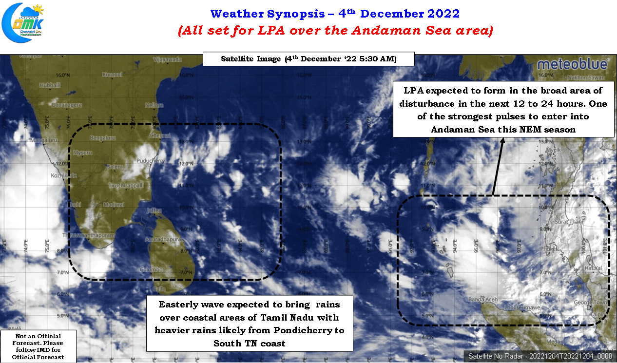
Over the next few days most weather bloggers are going to eagerly track a development that was picked up by models well in advance though there continues to remain a fair bit of divergence in the eventual impact which is expected considering the way most weather models are structured and the dynamic changes that happen with atmospheric conditions in real time basis. A fresh pulse has entered into the Andaman Sea area, one of the strongest in recent times at the time of entry, embedded as a cyclonic circulation in a broad area of disturbance along the Equatorial waters and adjoining Andaman Sea. There is a very high possibility over the next 12 to 24 hours IMD may call the formation of a Low Pressure Area in the same region.
Weather models are in a fairly tight agreement for the next 48 hours or so, what we would like to call as Phase 1 of the 3 phase sequence of events expected for this disturbance, until the morning of 6th December in terms of the LPA potentially becoming well marked and heading in a WNW direction towards east of Sri Lanka. There is reasonable convergence in terms of intensity estimates as well though one or two models seem to pick a deeper disturbance. The subsequent 48 hours there is some bit of divergence among models in terms of the movement with some continuing a more WNW approach while a majority opting for a more pronounced NW track towards coastal Tamil Nadu and adjoining areas of Pondicherry. There is a very high possibility during the Phase 2 we might see the disturbance intensify into a marginal cyclone. Whether we would have a named cyclone or possibly end up with a deep depression will remain one of the question marks in addition to the potential movement.
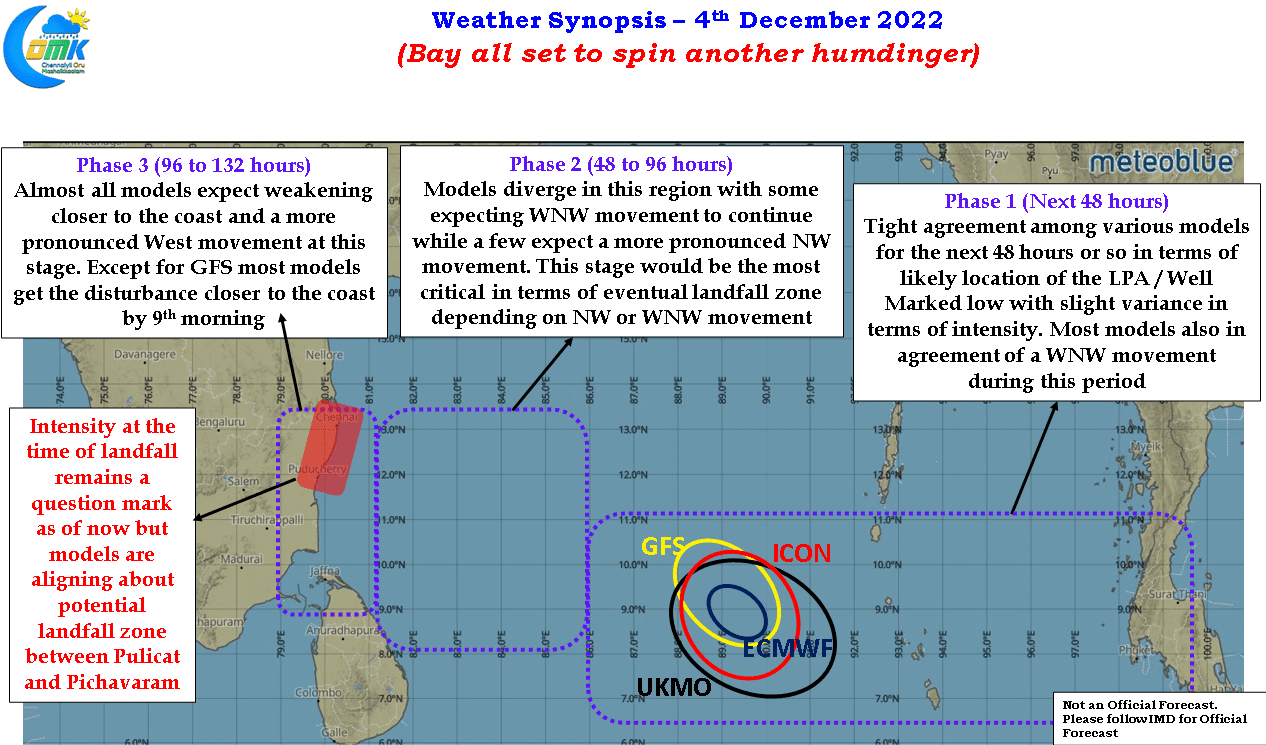
In a way this 48 hours during Phase 2 is expected to be the most crucial period of the upcoming disturbance deciding the eventual destination, intensity at the time of landfall and rainfall impact etc. Models also seem to align about a potential weakening before landfall as the disturbance approaches closer to coast though this remains a bit of a wildcard and need to be closely monitored in real time conditions. Looking at the overall scenario among the various models there is a fair alignment on the landfall zone between Pulicat and Pichavaram as things stand now. Further clarity on the exact landfall zone may evolve once we cross the first 48 hours phase. During this time we will also get further clarity on the rainfall impact during Phase 3 as well when we get to Phase 2 and the 48 hours during Phase 2 in a way will also indicate if there is a potential very heavy to extreme rainfall episode possibility during Phase 3 as the disturbance makes a landfall.
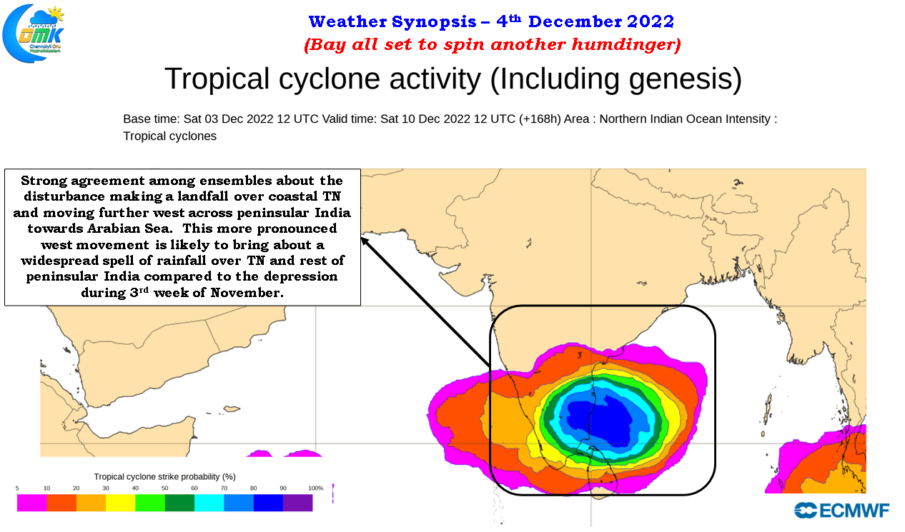
There is a high degree of confidence we could have a proper landfall scenario with the upcoming disturbance unlike the previous two instances which moved across coastal Tamil Nadu as a broad low pressure area. Ensembles are showing high degree of alignment of not only the upcoming disturbance crossing coast at least as a depression during Phase 3 but also more pronounced movement further west across peninsular India towards Arabian Sea. This critical difference is also going to be a factor in potential impact from rainfall as well. The west moving disturbance is likely to bring stronger easterlies over the coastal areas enhancing the rainfall over these places.
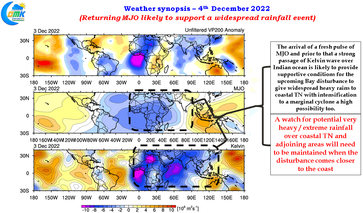
Additionally the presence of Kelvin wave and the potential arrival of MJO in a couple of days time over Indian Ocean is another factor that could not be ignored while trying to summarize the life cycle of the upcoming disturbance. The passage of MJO over Indian Ocean increases the probability of the upcoming disturbance intensifying into a marginal cyclone though question marks will remain on the intensity at the time of landfall. Additionally we may have to keep a watch on a possible very heavy rainfall / extreme rainfall episode over coastal area. The probability of this event and potential impact zone will be clearer when we get to Phase 2 of this journey.
In the meanwhile over the next couple of days coastal Tamil Nadu particularly to the south of Pondicherry may see moderate rains at many places with one or two places seeing heavy spells. Once the disturbance deepens there will be a small pause in the rainfall activity as the disturbance pulls moisture towards it before returning back during the Phase 2 & Phase 3.