
On Monday the COMK automatic weather station at Anna Nagar accumulated more than 7 cms through two different spells of high intensity rains. The first spell happened around mid-day and brought in nearly 40 mm of rains in less than 30 minutes while the second spell happened later in the evening bringing more than 30 mm rains in about 20 minutes. In a pattern that is slowly becoming regular around the Greater Chennai region short bursts of high intensity rains is bringing a different challenge for the urban planners from the perspective of disaster management. The now more infamous Sirkali rains that brought in more than 40 cms, with bulk of the rains falling in less than 6 hours, also highlights the inherent risk northeast monsoon always carry in terms of high intensity short duration bursts across coastal Tamil Nadu most of which is linked to disturbances that slow burn over the Bay of Bengal.
Since the onset of northeast monsoon 2022 on 29th October ’22 we have had two distinct rainfall episodes, the first one coinciding with the onset brought about by a trough of low that lingered off the coast of Sri Lanka and at times wandered into GOM region. The second episode happened a week after the first one ended brought about by the well marked low that eventually washed ashore around the delta district bringing about the highest one day rainfall accumulation for TN & PDC sub division on12th November. Now it is time to look forward to the third one which once again seems to follow the weekly pattern like an Indian Railways weekly express. In a way the regular pulses coming in from South China Sea is responsible for the weekly schedules for us.
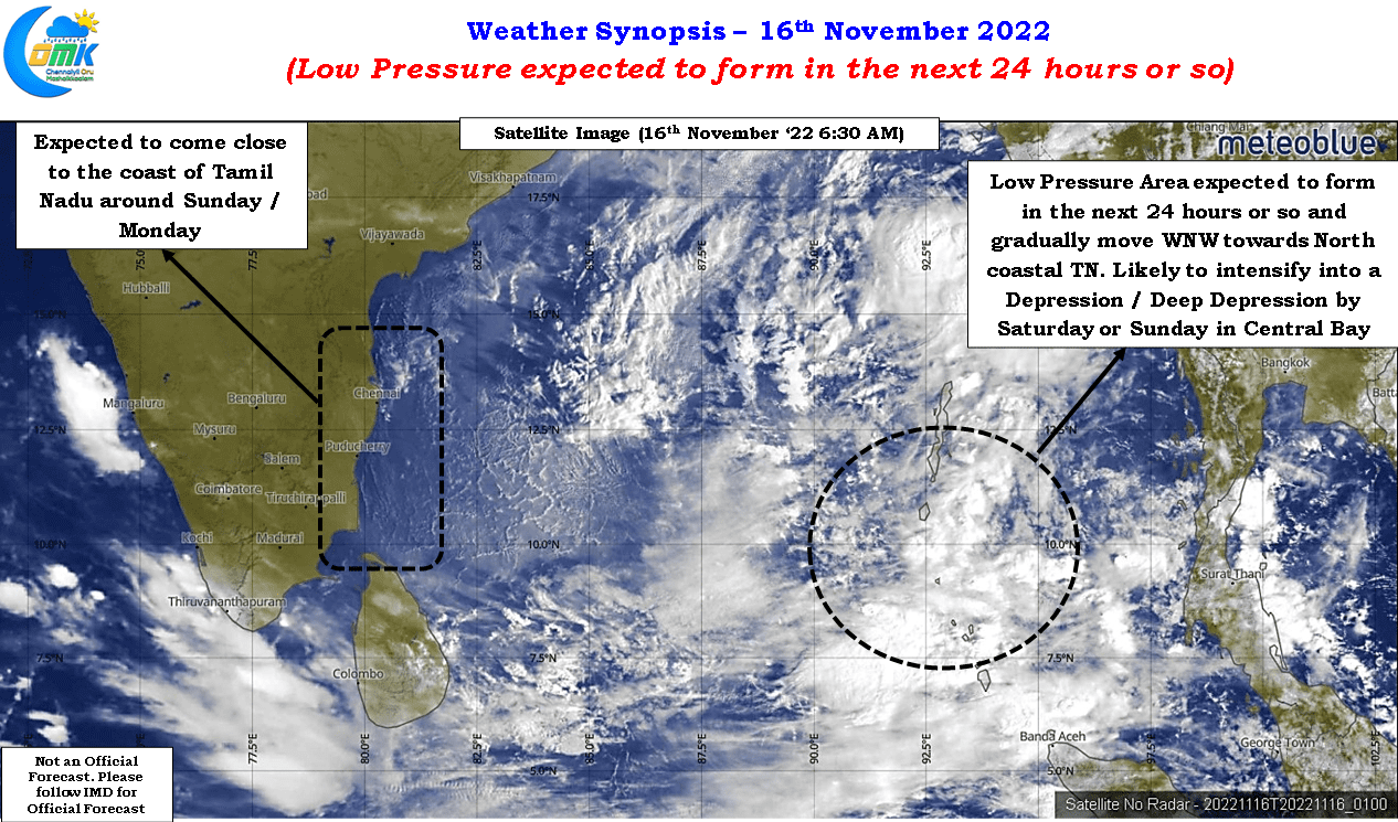
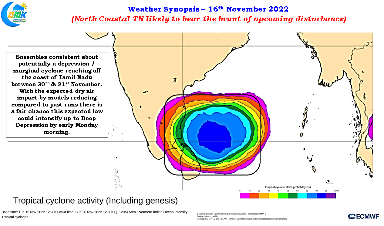
IMD in its update yesterday had forecasted the development of a Low Pressure Area over southeast Bay that is expected to move in a WNW direction. Ensembles are in agreement about this disturbance deepening into a depression by the time it reaches Central bay. Subsequent to reaching central bay models start to diverge in various scenarios due to the presence of dry air over Peninsular India brought in by the northerlies. While most models seem to indicate the depression to continue its WNW track towards coastal Tamil Nadu with the likes of ICON and GFS maintaining similar intensity while ECMWF was an outlier taking a WSW track after losing intensity. If we look a little deeper one thing that comes out gradually in the last couple of runs of ECMWF is a trend of slight intensification compared to the earlier runs which could mean ECMWF also shifting towards the scenarios shown by ICON.
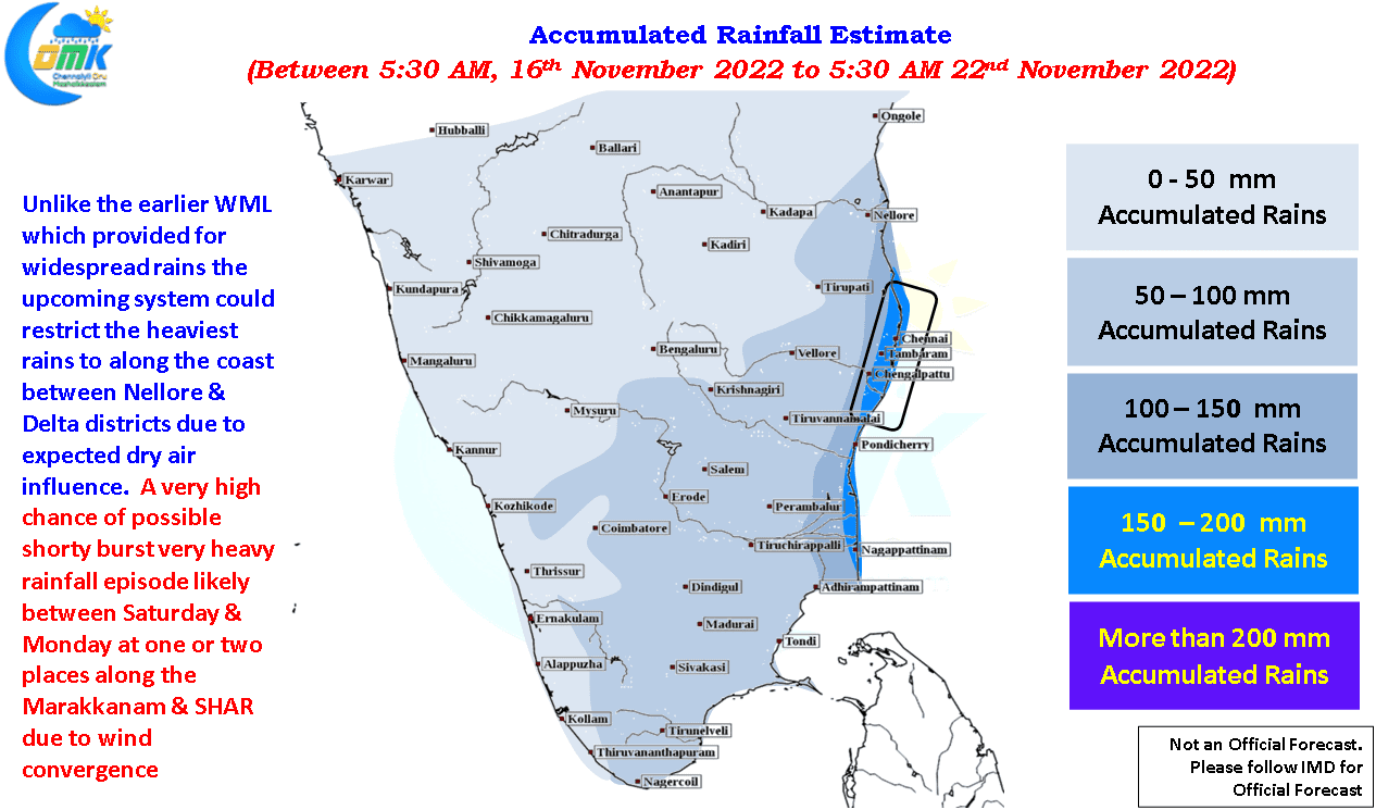
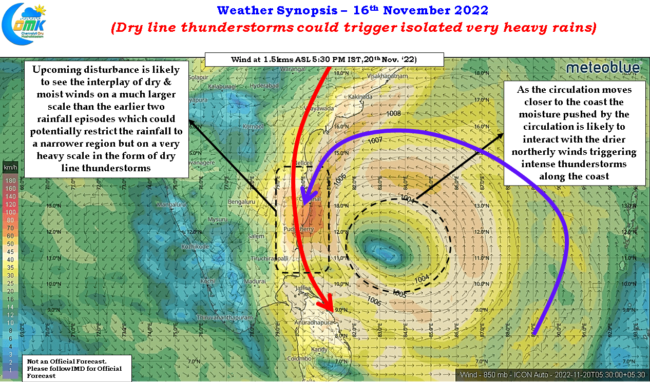
Incidentally ICON was one of the better performing models during the recent Well Marked Low as well in terms of dynamics though the precipitation estimates were off which has been the case almost always with ICON. This could mean potentially the LPA may intensify into even a deep depression before it reaches closer to the TN coast though the GFS solution of a marginal cyclone may be a case of over estimating things. This developing uniformity among models may mean the upcoming rainfall episode is likely to bring a bit of a worry for the people of north coastal TN. While the overall coastal stretch between Nellore in South AP and the delta districts will remain vulnerable for widespread rains during the weekend the presence of dry air is likely to create a situation of isolated pockets coming under sudden burst of very heavy rains through dry line thunderstorms.
We have seen in the past dry line thunderstorms dump a lot of rains in a short duration creating a huge challenge for the storm water drain infrastructure. While the actual location of these dry line thunderstorms could change depending on real time wind conditions the stretch between Sriharikota (SHAR) and Marakkanam may remain highly vulnerable for such burst of rains between Saturday & Monday depending on the movement of the depression. Overall though it could mean another weekend where many coastal areas of Tamil Nadu between delta and Chennai may see accumulated rainfall around 20 cms while isolated places could see rainfall accumulation as high as 35 to 40 cms by the same time next week.
With dry air expected to be a major influence when the disturbance reaches closer to TN coast, there is a very high possibility the upcoming disturbance may not give as much rains as the previous WML for the interior areas of Tamil Nadu. Coastal areas though have a very high chance of getting similar precipitation accumulation as the last one.