
Pendulum is one of the favorite word of this blog, while it is used regularly to explain the rainfall pattern during Southwest Monsoon & the thunderstorms over the leeward areas of Tamil Nadu. Today we will use “Pendulum” in the classic way – “a sign of changing times”. Both satellite images & wind charts from weather models have started to indicate the pendulum is now swinging back towards Northeast Monsoon from Southwest Monsoon season. IMD has pretty much confirmed they are drawing the final bit of the curtains for Southwest Monsoon in terms of completing its withdrawal over the Indian Sub continent
But before that the next few days are likely to be interesting for those areas which eagerly await the transition seasons (both Summer to SWM & SWM to NEM) for their best spell of rains under normal circumstances. In particular West Interior Tamil Nadu which mostly misses out monsoon rains from both west & east except during occasions when East to West moving disturbances cross the lower latitudes of Peninsular India or a stationary disturbance gets parked over the Comorin Sea.
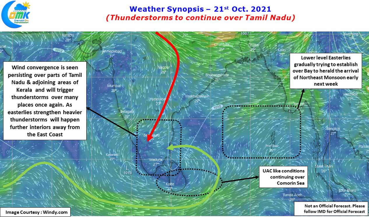
Yesterday saw fairly widespread thunderstorms over many parts of Tamil Nadu with places in West TN & South TN seeing moderate to heavy spells at times. Today once again the wind convergence triggered by the UAC over Comorin Sea is likely to bring thunderstorms to places along the Eastern slopes of Western Ghats. One or two places in Tirunelveli, Tenkasi & Kanyakumari district may see heavy spell of rains during the late afternoon evening hours.

Some of the regular readers may wonder why Chennai’s chance for rains have faded away now that Easterlies are sneaking in. It is interesting to note while Easterlies are sneaking in influenced by the UAC over Comorin Sea we do not have the monsoon winds yet. When the monsoon winds come in they carry more moisture from the Bay, but now what we are seeing is weak moisture being pushed across the coast. As the moisture travels inland it starts to raise due to the day time heating starting the convective process for thunderstorms to develop. So if one observes carefully the few days preceding Northeast Monsoon Onset will see thunderstorms skip places closer to the coast but places about 20 / 25 kms away from the coast sees thunderstorm develop as the convective trigger happens.
Chennai & suburbs will see similar phenomenon for the next few days, places along the coast line will miss out mostly while the western suburbs around 20 kms or so away from the coast line will see thunderstorms during afternoon time at a few places. These storms will eventually start moving further inland as the Easterlies pick up pace pushing the storms further & further Inland as Easterlies strengthen. Eventually when the streamlined Easterlies arrive with the moisture from the Bay rains happen for coastal places more often than not places around Chennai may see thunderstorms during onset because of converging dry & moist winds.