

With each passing day the mood among weather bloggers is gradually increasing with expectation about the onset of Northeast Monsoons. Every run of every available weather model is dissected & discussed threadbare. Different theories are put out on why Model X is reading the situation better than Model Y not to forget many a times weather bloggers tend to put their eggs in one basket, the basket that suits their needs, so you could find two different bloggers from two different parts of the coast trying their level best to convince the other on which scenario is likely to happen because the one closer to their heart seems to be in sync with their expectations.
Finally though it is Nature’s call on how things will pan out. Just like Time & tide waits for none nature also does not quicken or slacken its pace of churning events to suit our interests. It is also that time of the year when the phones start over heating so much, due to the multiple windows / apps / messages by the dozen every minute in the by now lost count of weather groups in WhatsApp, you could possibly use it to iron your clothes in the event you are not able to locate your Iron Box.
But in all fairness to the bloggers, there is not a group anywhere in the country who are passionate about weather as much as the weather bloggers down south. And possibly the most optimistic as well just like how fans of Dhoni think it is never over until the fat lady sings, the weather bloggers never discount any cyclone coming towards their coast irrespective of how it is heading.
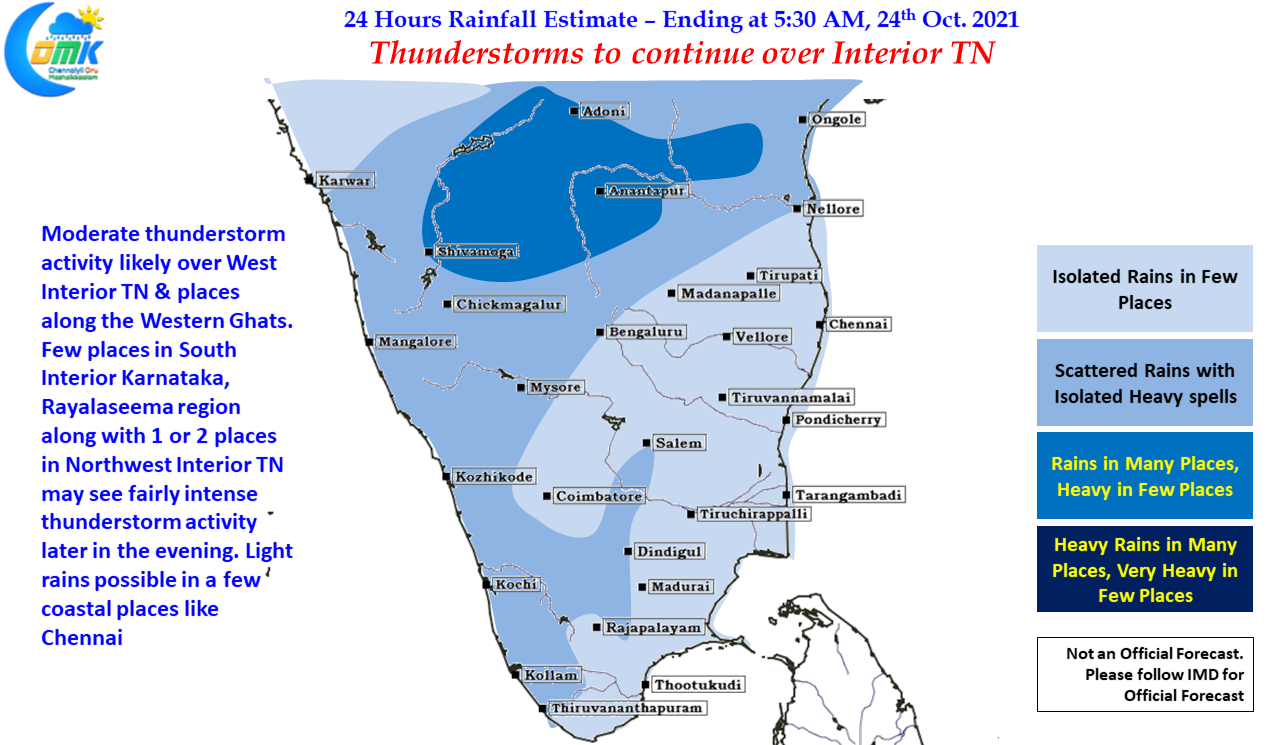
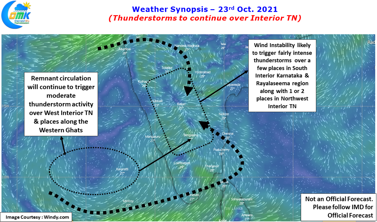
While almost all of us wait for the onset of Northeast Monsoon, there is still some unfinished business that is continuing as far as thunderstorm activity goes. With IMD expecting Southwest Monsoon to complete its withdrawal by 26th of October the next couple of days we will continue to see thunderstorms triggered by wind instabilities over the interior parts of TN. It will reman mostly an interior show until we start seeing moisture pushed by Easterlies from Bay post which it is time for those bloggers from Chennai to start singing
Rainfall in Punjab. Under the influence of Western disturbance:
Gurudaspur aws – 39mm
Nur mahal kvk – 34mm
Ludhiana – 23mm
Ferozpur kvk – 35.5mm
Ferozpur – 31mm
Fategarh sahib – 14mm
Moga – 12mm
Ropar kvk – 28mm
Sangrur – 12.5mm
Budhsingh wala kvk – 13mm
Fairly widespread rain in desert region of West Rajasthan:
Sriganganagar – 35mm
Hanumangarh – 25mm
Hanumangarh kvk – 12mm
Good morning, bright sunny sunday morning. Easterly winds in, expecting some good rains from today for coastal and interior TN.
Konni 131mm
Punalur 75
Kottarakkara 68
Enamakkal 60
Seethathode 60
Neyyattinkara 59
Kakkayam 53
Peringalkuthu 51
Thenmala 38
Peermade 27
Vellayani 24
Muvattupuzha 20
@Srikanth try to read my post here
https://cricketwriters.wordpress.com/2021/10/23/changing-indian-ocean-influencing-indian-monsoon/
CPT – 5 mm
Missed the bulk what our street received it seems
MKM – 27 mm
Srivilliputhur 45 mm
Wow. Last couple of days has been good
Yes anna
Most of the heavy spelle are not recorded in vnr due to lack of rain gauges!
Rains skipping that areas..
My place would have got easily 4 cm yesterday..
Nothing recorded in rg as it is in south west
Svks south and south east would have got more than 10 cm for the month
Official rg is less than 6 cm!
How I can post in the name Vimal?
You can edit through your WordPress profile or let me edit for you in a while
Sir you can edit it
Good Morning
Onset in a few days
Seeing the current atmospheric conditions how GFS blowing into a depression/tropical storm . Does GFS do an impossible?
Expect the unexpected from GFS
Going by it may even show cyclone forminh and intensifying in land during NEM
You are having effective mid latitude wave response produced out of north Bay convection/Indonesia – North Pac. And active convection near SPCZ is creating a wave response in southern hemisphere. Until these two areas of convection settles, there will be very little forward progression of MJO into IO from Africa.
The Kadirvedu football ground has puddles of water, looks like parts of North Chennai has got decent overnight rains
Good morning to all ❤️.
Have a nice day 😊.
Aha ohh butterfly butterfly
rains starts with butterfly song…mojo effect seen from admin… expecting more chill songs for upcoming awesome days❤️🙏
I always think the pre NEM cloud bands off the coast resemble butterflies.
it’s looks alike🦋
ECR getting heavy rains it seems
Lucky place
Test!
Testing!! HHRainman@Mdvk/Mdmk here
Mahabs getting heavy showers
The cooling horseshoe of southern IO from west AUS is something to keep an eye when forecasting Tropics. This is a trend basically since 2014 where region over AUS is cooling. This may create overhead subsidence over western IO and how it affects Tropics further needs to be seen
Unlike 2016 2017 time we have strong pressure gradient between EPac and MTC. Expect trades to be more stronger in Pacific and re-intensify the Sumatra Indonesia Walker cell. The active SPCZ zone and MJO don’t support a cyclone what GFS shows. A weak system to cross TN is likely solution and at same time South china sea pulse may interact with western trough and head up. Only after these two events we may see established NE monsoon over us.
Since ICON forecast lead time is just 180 hours (which is 8 days), it has just started to pick a circulation like feature off SL coast on Oct 31, may be there will soon be some consensus there, initial trough feature now pushed by most models to Oct 28/29 or later
Anyone saw NavGem forecast? 😛
Gem also pick good circulation now
GFS consistent .pick dd or cyclone for gom.
How many of you here believe GFS forecast on month end disturbance?
🤣 🤣 🤣 🤣 🤣 NaLLa KElVI NAlLa KElVi
There is a chance of disturbance around Oct 31 due to kelvin induced WWB, need to see if other models agree, but the onset trough shown earlier starting Oct 26th has been removed and slightly being pushed till Oct 29 even by GFS/GEM now as the shortwave induced by current WD affecting Kashmir fades away
தூத்துக்குடி, விருதுநகர் மாவட்டங்கள் தான் அக்டோபர் மாதத்தில் மழைக் குறைவாக பெற்றவை.
Eastern parts of virudhunagar is very bad…If there is taluka level deviation, we will get clear picture
Yes
My place should have got close to 11 or 12 cm(atleast 4-5 cms today or even more)
Official rg need to wait for tmrw readings
GFS holding on
Same fate following me …not a drop Last 2 days ,when I’m here in my native☹️
You went to native???
So chennai going to get rainz tomorrow?
I’m coming tmrw there,🤣🤣😝
Rainfall till evening(in cm) :
Katra-9;
Jammu-8;
Qazi Gund-7;
Baderwah and Pahalgaon-6 each;
Kokarnag, Banihal and Batote-5 each;
Srinagar-3;
Hut bay – 1
Minicoy – 1
Thunderstorms over west Rajasthan, Punjab, jammu region. WD influence
South peninsula filled with thunderstorms!, NEM will arrive soon.
Just for Fun.. Today the comments section color codes be like 😀
Haha, the color actually means unread comments, once u click on the comments or reload page, it’ll return back to normal
Mmm.. but I meant the profile names are with different colors.. ☺️
Black, light blue, dark blue, green, brown, light orange, dark orange, red, pale yellow are the different colors we can see in comments section.. ☺️
That’s actually looks colourful for me Jagan ji,.. I love it…😁
Mmm.. colorful ah irukardhu naala thaan kozhi kunju photos vachu compare pannen.. 😜
Sass neenga anuppnadhum thaan sonnan Jagan ji..🤩
That looks good sailuji… previously I ll be searching for new comments in blog …here that colour variation Is good to identify new comments..❤️😍
Looks colorful!
Drizzle started. Lightning in the north. Mostly anvil crawlers. Image uploading works now.
Great finally you were able to upload. As usual nice capture
Good rains in and around Sivakasi surrounding and a decent spell here upto Rajapalayam town and ghats also.
Yes sir
It was a great spell here
Lucky…Still our area have not got any meaniful rains apart from stray showers
Hopefully nem helps the entire vnr district very widespread
How is your area missing everything Selva?
Super sir, nice to hear Ghats getting the rains
Rainfall in Karnataka till morning (in cm) :
Belthangadi (Dakshina Kannada dt) 5,
Chikkamagaluru 5,
Mysuru 5 ,
Dharmasthala
(Dakshina Kannada dt) 4,
Hassan 4,
Channagiri (Davangere dt) 4,
Hoskote (Bengaluru Rural dt) 4 ;
Subramanya (Dakshina Kannada dt) 3,
Nanjanagud (Mysuru dt) 3,
M M Hills (Chamarajanagar dt) 3,
Napoklu (Kodagu dt) 3,
Thondebhavi (Chikaballapura dt) 3 ;
Brahmavar Aws 2,
Karkala (both Udupi
dt) 2,
Ponnampet (Kodagu dt) 2,
Jayapura 2,
Kadur (both Chikkamagaluru dt) 2,
Halebeedu 2,
Belur (both
Hassan dt) 2,
Magadi (Ramanagara dt) 2,
Agumbe 2,
Bengaluru City 2,
Chintamani (Chikaballapura dt) 2
Koppa, Yagati, Kammardi, Balehonnur, Ajjampura (all Chikkamagaluru dt), Hesaraghatta
(Bengaluru Urban dt), Konanur, Alur, Arkalgud (all Hassan dt), K R Nagara (Mysuru dt), Rayalpadu
(Kolar dt), Gowribidanur (Chikaballapura dt), Chikkanahalli Aws, Madhugiri, Sira, Midigeshi (all
Tumakuru dt), Bhadravathi (Shivamogga dt) 1 each.
Not much as expected
Good rains happening now in Periyanaicken Palayam Coimbatore.. my sister said..
Btw ECM quite consistent on tuty getting first widespread nem spell on 25th night/26th morning ..looks like a good start to them again similar to last 3 years
I have subscribed notifications for “new replies to my comments”. But I’m also getting notifications for other conversations where I’m not part of.. ☺️
Any idea we can increase the cap for image upload size to 6 MB?, Is it a wordpress limit or the admin can set?
I think Admin can set.. morning it was 2 mb.. now it’s 4 mb..
I also feel the .ini or php can we tweaked, anyways, wanted to post a video, converting to GIF increases the file size proportionally
Ok
Earlier with Disqus the images were getting stored in their servers, now it will be stored in the Chennairains server…already we have added the comment load now to the server which earlier was at discus side. Let me check the load pattern and take a call
Oh okay got it thanks
4mb mela server thaangadu
Erode district batterd last night.kavindapadi 100 mm again.erode isro 49 mm.erode October total 286mm
Are you “Anandha kannan”?
Anand erode
Ok, I was not able to recognize you.😃
Are u able to re-“cognize” me Chris?
Yes😃
who will not!!
Hii
Hii , you are “Anandha kannan”, right?
Hy..I use my disqus I’d as anandha kannan
Ok ,so what’s your real name?
Raja
Wow!, Nice name😃😊👑👑
Kerala crosses it’s annual NEM tally of 491mm, now at 506mm.
Kerala has also crossed 500mm for October.
The highest single day(24hr) rainfall for Kerala in 2021 was on October 16th when a massive 80mm was recorded for the state as a whole.
NEM tally crossed even before NEM started.. 😀
Yes, it was completed in the first 22 days itself.😊
Oh good
Near continuous rumbling and lightning south east and east. Rain continues in west and north west.
Unable to attach 70 KB image from desktop. 1280 x 960 resultion.
Can you clear your cache & see. I had the same issue with my browser
Shabba . Every year the same story .
Suspense thriller film madhuri than irruku NEM
Always. NEM is never easy to follow like CSK
Rainfall till now :
Anantnag – 76mm
Udhampur – 66mm
Rambagh Srinagar – 34mm
Srinagar AMFU – 27mm
Pulwama – 26mm
Govindpura – 36mm
Kishtwar – 25mm
Samba – 21mm
Shopian – 56mm
Reasi – 58mm
Shopian snowfall video this morning from my close friend 🙂
Like last year, its the same North America vs Europe this year as well :P, may be revenge for Nivar or another loss needs to be seen 😛
Going to be Battle Royale this NEM season surely
ECM looks to be finally converging to ICON solution regarding the shortwave trough influence hampering our initial rainfall chances, ICON has been performing really well with shortwave events and its influence on tropical systems this year across the globe
ICON picks up the trend quiet early, if one we can read it well
Then no widespread rains possible for TN?!
Personally, I am interested only around/after Nov 1st week or Nov 10, enjoy on/off rains until then, but the influence of CCKW entering WIO now needs to be seen, there is a possibility it gets absorbed to SH again
🙏 ❤️ 😁 ❤️
Yea
Thought of updating the leaderboard of the NEM Fantasy contest being played by the bloggers. It is interesting to see how similar set of stations give different results to teams based on how they choose the combination & carefully use the Captain & Super Sub strategy
Finally some high intensity spells in sivakasi for more than 30 min
Slowed down just few min before
Wow. Good to see VNGR dt getting some rains
Yes anna..much needed
Multiple rainshafts west and north. Rumbling in the east.
unable to attach image
If your image size is more than 2 MB it may not be possible to attach, can you check and confirm
382 KB. On mobile. Shows a busy animation and fails.
Surprising, I was able to upload images in both platforms
I am able to attach more than 2 mb images also
More than 2 mb test image.. 2.59 mb
Have enabled up to 4 MB
Where to see if someone replied us or not?
You could use the subscribe button on the comment box to subscribe to new replies to your comments
Ok
A perfect cylindrical container can be used as manual rain gauge?
Yes. You can keep a perfect cylindrical container, may be add about 1 inch height of pebble / sand to ensure the accumulation is near perfect
I have to fill pebble even though the bottom is flat?
If the bottom is completely flat then you may not need to fill pebble
Ok thank you sir
ReTest
Exam ku kooda ithana tests ah naa paathadhilla…evlo test eludhuringa ellaarum
😁 😁 😁
Haha
Test
Able to change the display name from WordPress profile
Yes we have to change the display name in WordPress Profile edit option
Hi
Hi Santhosh, any rains in Villuppuram
From valavanur to mundiyampakkam get’s some rain but Villupuram town completely missed out
My mom for the past few days has not been talking about rains, so I assumed the rains have to some extent slowed down
I agree all of us have got used to Discus & its functionality, especially the live commenting etc. But off late issues with spam comments have forced us to look at alternatives. It may not be as nimble as discus but surely much better from privacy point of view
Especially the data tracking that Disqus does
True. It is scary at times. For me the worst thing was, slowly every moderating tool was being shifted to a paid platform & the first slab was at 99 USD which allowed you to meaningfully moderate.
Good switch after the configurations and edits, hope all would adapt soon
Test
Hearing Hearing…
But I have set my display name in WordPress as Jagan@GudalurNilgiris.. but instead it is showing my google account profile name.. 😀 believe me I logged in via WordPress button only
Thats since the wpdiscuz recognizes as same profile.. did you try changing ur profile after logging to name of your choice ?
Ya it’s working now I guess ☺️
Thanks for the support 👍
No Issues, please refresh & see now
Ya it’s working after refresh.. thanks ☺️
I have just changed the display name through WordPress. We will slowly find solutions for everything dont worry
Ya sure.. thanks
Is there any rains over there?
I have changed your display name to Chris @ Kochi
Ya in the noon.. light to moderate rains for 20 mins.. what about kochi?
Logging in from a different WordPress account
Like button functionality restored
Super
Enna pa blog la wind reversal happening ah 🤔. Like edit comment panradhellam kashtama iruku 😌.
Edit button should work now. Please check
Please check if the like button is working.
Edit: And edit also should work. I have just edited this comment
Ya like button and edit are working for me.
But any idea why word press account doesn’t work here?
Ideally should work, log out and trying logging in with your wordpress account
Ok I tried many times today.. let me log out and try again
Let me check and come back to you. Give me some time
Ok thanks.. just for reference sharing below details.. the 1st screenshot shows my credentials works fine in WordPress website.. 2nd screenshot shows the same credentials doesn’t work in comk website..
2nd screenshot
I have just sent you a password reset link, check if you have received & you are able to reset your password
If you have a WordPress account..try this, login into wp using the button from the comment box…any other method will keep redirecting you to login window only
Yesterday night it wasn’t working for me ,but today it is
Oh ok..
A perfect cylindrical container can be used as manual rain gauge?
ICON is consistent of dry period between oct 26-28
ECMWF is also changing
GFS is consistent in it’s forecast
Still no consensus among the models
Raining at ayapakkam
Srikanth sir.. if possible let’s continue using Disqus for some more time ☺️ in this new tool some features like voting, edit, and new replies are not working properly..
Please check if you are able to vote / reply & edit now
Able to vote now..
Edited this msg..
Great now only we need to figure out a solution for the WordPress login
Ya correct
Yeah comments not updating !!!
Need to refresh !!!!!
NEM kulla ethachu pathu seinga pa !!!
Give them a day or two , we are in transition period isn’t it , so it will be confusing 😋
Yes, let’s wait!
Comments should refresh every 30 seconds. Check the bottom right hand corner if you are seeing a orange blurb with number of new comments
Ecmwf
It’s changing, looks like WD influence will be there
We need to refresh the page to view the replies for our comment..
There is a orange circle with no. of replies we received but tat doesn’t work when we click on it.. it just keeps loading…
SO we need to refresh the page to view those..
_SS on Twitter: “@ChennaiRains view of West https://t.co/Ow0O6OQA7R” / Twitter
Moderate rain in past 10 mints
Action around Bangalore
Is like button working for u?
No
Mmm ok
No ji
Mmm ok
No bro for me also not working
Ya it’s not working for anyone.. 😔
Good. Here it’s silent.
I didn’t like this comments tool.. 😔 color codes are not looking good..
I created an account in WordPress but those Credentials are not working here..
Hi
I am Chris@Kochi.
Another promising skies here at Trichy. Yesterday ~1cm at Manual RG
Moderate rains happened for 15 mins in Gudalur Nilgiris
After rains one cloud stayed back..
East getting dark hope it will rain soon at Villupuram
Valavanur la rain bro
Enjoy, here we are waiting
♦ Southwest Monsoon has further withdrawn from remaining parts of Northeast India, West Bengal, Odisha; entire north Bay of Bengal and Goa; some parts of
Andhra Pradesh; remaining parts of Telangana and some more parts of Karnataka and Central Arabian Sea. The Southwest Monsoon Withdrawal Line now
passes through Lat 18.5°N/Long 94°E and Lat 18.5°N/Long 90°E, Kalingapatnam, Nandigama, Kurnool, Gadag, Majali, Lat 15°N/Long 65°E and Lat
15°N/Long 60°E
-Courtesy IMD
Bye Bye SWM 2021 , We will meet in 2022!
Two different pulses by the look of it
Interesting .If the Bay is able to host Fujiwaras , then we can coexist peacefully with our neighbours in AP and Odisha 😊
ECM not consistent
Dark clouds heading from East here in my native
Hi COMK…New change…nalla irukku….hope soon we ll used to it till we back to Disqus..😍
https://twitter.com/sunnewstamil/status/1451823754405761029?t=OzInTUqr5_1J4WOYzDOEMA&s=19
Interesting
South Karnataka early Thunderstorms at many places
GFS vs ECM
Hi , hello
Hello Comk ❤️
image test
Hi COMK!
We had a good spell of rain at Peelamedu, Kovai this morning between 4:30 to 5:30am.
Hello All!!
Rainfall in J&K till morning. Impact of Western disturbance(in cm) :
Govindpura 6cm,
Anantnag 6cm
Khudwani 6cm
Qazi Gund 6cm,
Kulgam 5cm,
Kukernag 5cm,
Udhampur(Iaf) 5cm,
Banihal 5cm,
Awantipur Iaf 5cm,
Zainapora 4cm,
Pahalgam 4cm,
Konibal 4cm,
Srinagar 4cm,
Shalimar 4cm,
Katra, Kawa, Rambagh, Harran, Ganderbal, Rajouri 3cm,
Baramulla, Bandipora, Gulmarg R.S., Batote, Raj Pura, Gund 2cm each
Hi
Black colour for text possible?
It is possible, let me try to change & see
Thanks. Looks good
Hi Aadhi
GFS showing December system in October https://www.tropicaltidbits.com/analysis/models/gfs/2021102300/gfs_mslp_pcpn_india_25.png
Rainfall till morning:
Perundurai (dist Erode) – 9cm
Sathanur Dam (dist Tiruvannamalai) – 6cm
Annur (dist Coimbatore), Edapadi (dist Salem), Uthukuli (dist
Tiruppur), Musiri (dist Trichy) – 5cm
Erode (dist Erode), Bhavanisagar (dist Erode), Polur (dist
Tiruvannamalai), Sankarapuram (dist Kallakurichi), Rasipuram
(dist Namakkal) – 4cm
Ennore AWS (dist Tiruvallur) Chengam (dist Tiruvannamalai),
Tiruvannamalai (dist Tiruvannamalai), Kumarapalayam (dist
Namakkal), Kulithalai (dist Karur), Kothagiri (dist Nilgiris),
Gobichettipalayam (dist Erode), Thathiengrpet (dist Trichy),
Kodaikanal (dist Dindigul) -3cm
Ariyalur (dist Ariyalur), Krishnarayapuram (dist Karur), Sulur
(dist Coimbatore), Attur (dist Salem), Kallakurichi (dist
Kallakurichi), Periyar (dist Theni), Coonoor Pto (dist Nilgiris),
Mayanur (dist Karur), Denkanikottai (dist Krishnagiri), Karur
(dist Karur), Illuppur (dist Pudukkottai), Mettur (dist Salem),
Sankaridurg (dist Salem), Peelamedu Ap (dist Coimbatore) – 2cm
Thandarampettai (dist Tiruvannamalai), Sathyamangalam (dist
Erode), Bhavani (dist Erode), Ramanathapuram (dist
Ramanathapuram), Shoolagiri (dist Krishnagiri), Annavasal (dist
Pudukkottai), Thuraiyur (dist Trichy), Tiruppur (dist Tiruppur),
Nagapattinam (dist Nagapattinam), Tirupathur Pto (dist
Tirupattur), Ayyampettai (dist Thanjavur), Tirupattur (dist
Tirupattur), Krishnagiri (dist Krishnagiri), Hogenekal (dist
Dharmapuri), Erumapatti (dist Namakkal), Thammampatty (dist
Salem), Lalgudi (dist Trichy), K Bridge (dist Nilgiris), Sattur (dist
Virudhunagar), Coonoor (dist Nilgiris), Mannargudi (dist
Tiruvarur), Kamudhi (dist Ramanathapuram) – 1cm
Twitter login image test
WordPress login image upload
Google image test
Does not seem to be working for me for some strange reasons
We are able to see “Nothing to see here” Sailu😂
Snowfall in Kashmir valley
https://www.ndtv.com/india-news/j-k-snowfall-today-fresh-snowfall-in-several-parts-of-kashmir-ladakh-heavy-rain-in-plains-2584988
Logged in through Google account
Hello. Just to confirm, you can now login in addition to registering through WordPress itself, login using your Google, Twitter & Facebook ids
On the right hand bottom corner you will see a blurb that will show how many unread comments you have. You just need to click that to go to respective unread comments
Oh. New theme overall
cool winds from sea
Marina
Hii
Looks like I have to refresh the page everytime to see the new comments, the like button also not working
It will autonrefresh every 30 seconds..
Haven’t yet checked the like buttons functionality..will see 🙂
twitter login
Intensity slowly picking up in Gudalur Nilgiris
Very dark and light rains now with thunders
Test msg
It rained heavily for 20-30 minutes at ayapakkam
Groundstrikes towards WNW
Atlast logged in
Test
Srikanth, lots of colours, any chance of standardization
Test
HII
test
test
testing
reply test
Load more comments button is not working
I am able to access with Google account now
https://twitter.com/sln_1962/status/1451782138341167112?s=20 Cauvery getting good inflows through Shimsha
Southern bay getting active, as it intensifies, we will see our own NEM rains 🙂 for coastal TN.
Can we expect some Rain’s from this band
Will move slowly I feel, easterlies are still not strong
https://mausam.imd.gov.in/Satellite/3Dasiasec_ir1.jpg
The last of westerly rains for South TN. Expected rains. The end of the great monsoon of India.
Hope it gives good rains to West TN before we start looking East
2017 November . Rainfall from the North moving depression:
16th November:
Sompeta,AP – 18cm,
Ichchapuram ,AP – 17cm,
Mandasa ,AP – 14cm,
Palasa and Kalingapatnam 11cm each,
Gop, Tekkali and Astaranga ARG 9cm each,
Puri and Paradip 8cm each,
Digapahandi ARG,orissa – 7cm
Paralakhemundi,orissa – 7cm
Pathapatnam,AP – 7cm
Mahendragarh, orissa – 7cm
Tirtol ARG,Orissa – 7cm
Balikuda ARG, orissa – 7cm
Kujanga
ARG ,orissa – 7cm
and
Nischintakoili ARG, orissa – 7cm
Early morning rains in Kerala today.
Alathur 120mm
North Paravur 78
Kollengode 72.2
Chalakudy 72.2
Erimayur 67
Mannarkad 66
Thrithala 61.8
Kodungallur 54
Lower Periyar 48
Myladumpara 47.4
Aluva 45.6
Vayanthala 45
Keerampara 38
Ernakulam 38.2
Thrissur 37
Idamalayar 36
Palluruthy 36
Ottappalam 34
Vadakkancherry 32
Irinjalakuda 30
Kochi 25.4
Anchal 24
More colors used in theming.. so not looking standard when compared to Disqus..
in my opinion we could have tried this new commenting platform during off season around Feb/march.. ☺️
The issue with Spams in Disqus was becoming a little too much. Hence we had to opt for a different platform without any delay
Are there new commenters in the blog?, I am not able to understand many….
I am using Google account.. Jagan from Gudalur Nilgiris.. 😀
Rainfall till morning:
Baramulla kvk, J&K – 24.5mm
Bandipore, J&K – 24mm
Ganderbal, J&K – 29mm
Rambagh Srinagar – 34mm
Ramban J&K – 63mm
Udhampur J&K – 31mm
Anantnag J&K – 61mm
Good Morning All. We will be using the current commenting platform for the next few days to understand the pros and cons in real life conditions. So please bear with us in case at times you are not able to comment. Thanks for Understanding
Ok
Ok👍