
“Beware the Ides of March”
Words uttered by a soothsayer in William Shakespeare’s Julius Caesar
The Ides of March may have been uttered to warn Julius Caesar in the play written by William Shakespeare, but the weather blogging community possibly knows it is equally applicable as far as summer goes for Tamil Nadu. More often than not it is around the middle of March temperatures tend to notch up as Summer starts to spread its tentacles over most of Tamil Nadu. As explained many times through this blog it is initially the Western parts of the state that tend to see increased temperatures with South TN gradually following and subsequently North TN. Coastal TN, particularly the stretch between Pondy and Delta is possibly the last to join the Summer bandwagon.
While Anantapur became the first IMD observatory in the country to record 40°C this year more than 10 days back during the past week we have also had a few other observatories like Rentachintala, Cuddapah, Nandyal and Kurnool have also recorded 40°C from the Rayalaseema region in Andhra Pradesh. Gulbarga became the first IMD observatory from Karnataka to record 40°C yesterday. During most years the first set of 40°C from the Indian sub continent comes usually from Vidharba or in some instances Gujarat or Rajasthan. During fading El Nino years it is Peninsular India that makes the early run towards 40°C which has been the case this year too.
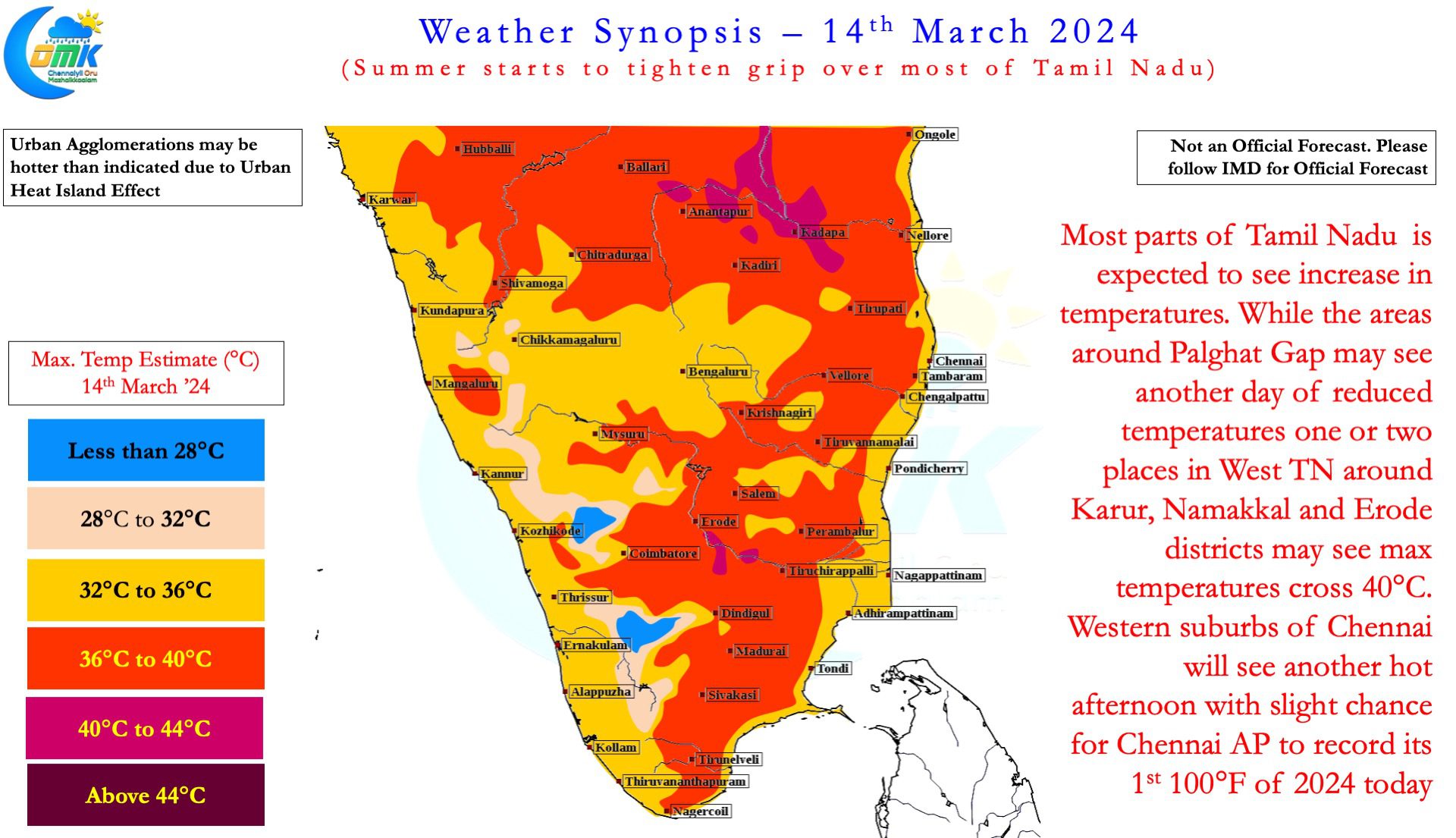
Karur Paramathy is known to be the first station to record 40°C from Tamil Nadu on most years. This year so far it has stopped just short off 40°C so far with yesterday’s 39.5°C being the highest for the year. Erode has been the hottest IMD observatory in Tamil Nadu for this year so far by virtue of the 39.6°C recorded on 8th March. Chennai has been relatively better off with a much cooler 35.7° recorded yesterday at the Meenmbakkam observatory being the warmest so far this year. But make no mistake gradually the temperatures have been climbing up across most parts of the state with weather models indicating the next couple of days seeing fairly hot weather across the plains of the state. There is a very high chance Tamil Nadu could record its first 40°C today or tomorrow with a slight chance for may be one or two suburbs of Chennai to make a dash towards the media favourite 100°F, (37.8°C) today or tomorrow
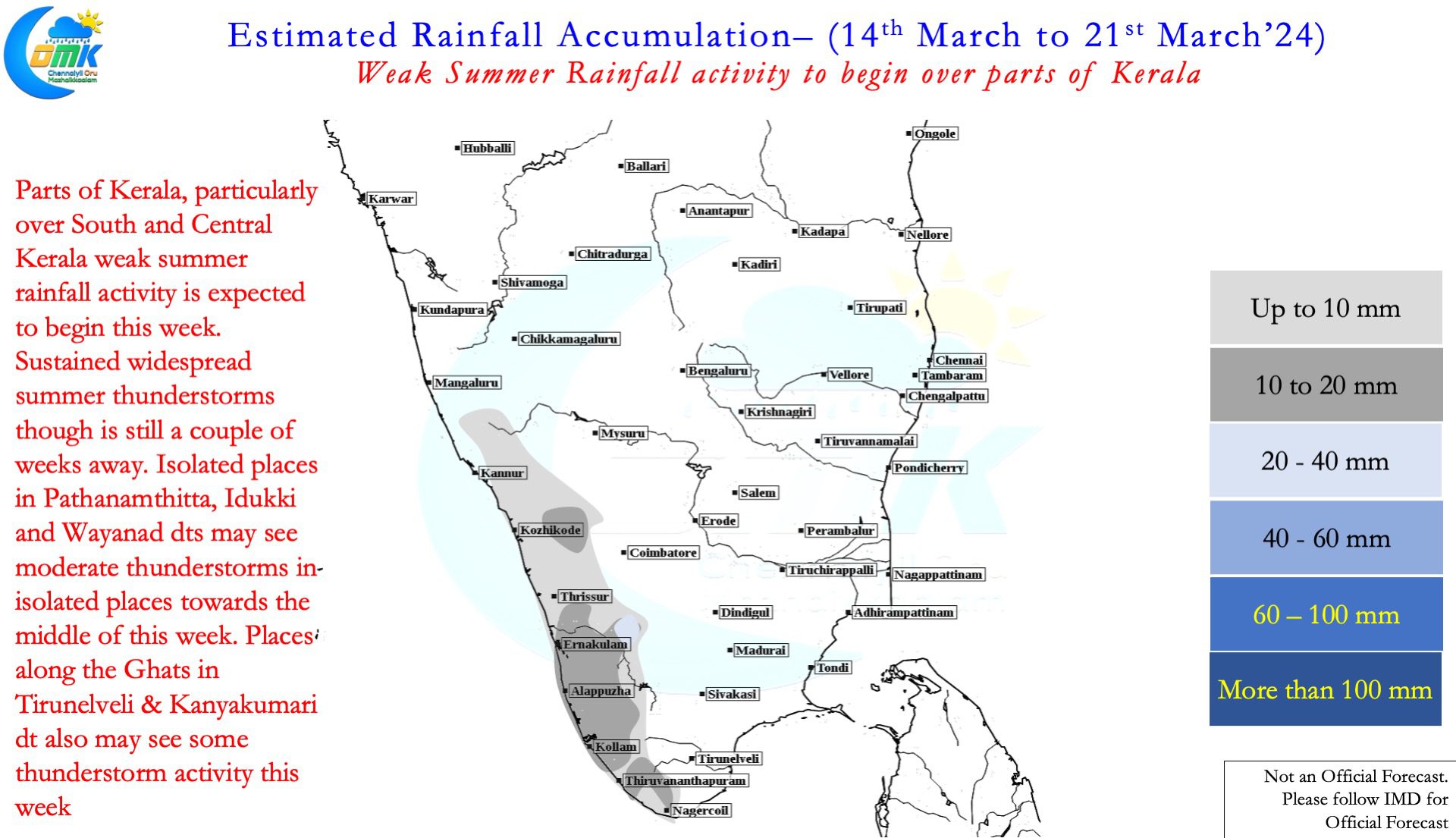
The Palghat Gap areas of Kerala and adjoining Tamil Nadu that has been reeling under hot daytime conditions saw some respite yesterday with reduction in temperatures, the next few days could be better than the past couple of weeks, partially due to favourable wind conditions with a more southerly component estimated by the weather models. The southerly component is possibly one of the reasons why North TN may see increase in temperatures as arrival of winds from east may be delayed during the afternoons leading to increased in temperature for places like Chennai. Also weather models indicate isolated weak rainfall activity from summer thunderstorms to happen over parts of Kerala that is likely to also help in reduction of temperatures. But it is not yet time to announce the onset of വേനൽ മഴ season but things look better for the start of summer thunderstorms towards end of March.