
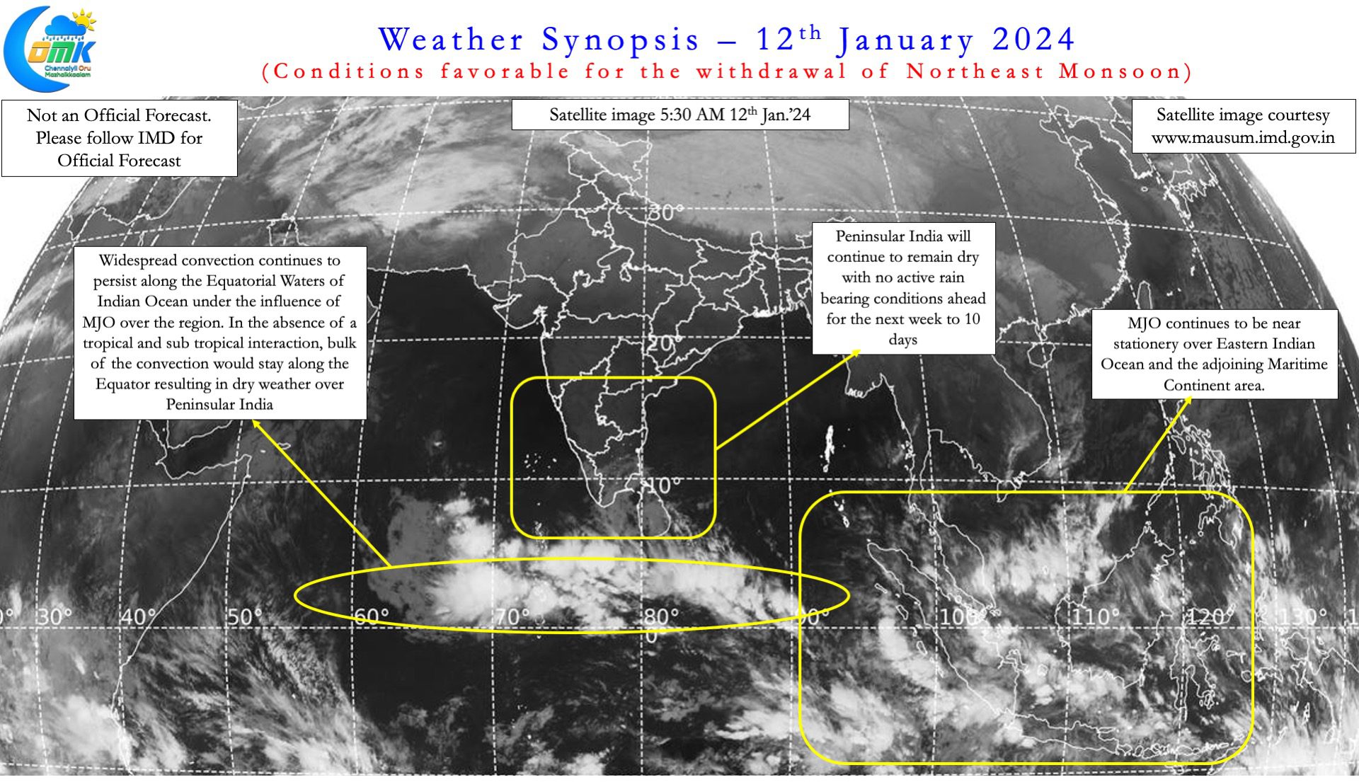
Over the past couple of weeks abnormal heat had gripped large parts of Peninsular India. Places in Rayalaseema regularly recorded 43 / 44°C. Closer home Erode recorded the first 42°C in Tamil Nadu. This spell of abnormally hot conditions brought about heatwave over pockets of South India during hte weekend. The abnormal heat has led to many people yearning for a spell or two of rains to bring some respite. So far summer thunderstorms have been sub par with no sustained spell of convective thunderstorm activity.
In a way the abnormally strong Easterlies are the reason for subdued thunderstorm activity. Ironically the spell of rains that is likely to happen over South Tamil Nadu and Kerala for the next couple of days is due to a weak circulation created by the Easterlies. The use of a satellite image as part of the post after nearly 3 months is possibly an indicator of changing times. On a slightly larger scale there is something that can be now tracked on a regular basis. ITCZ, the power house of monsoon dynamics is just south of Equator. It will possibly move into northern parts of Equatorial Indian Ocean in a couple of weeks. The arrival of ITCZ can give impetus to rainfall over the region.
A convective cloud cluster to the east of Sri Lanka will gradually push further west under the influence of a weak cyclonic circulation. This cyclonic circulation is expected to prevail over the Equatorial waters for the next couple of days. While the bulk of the rains from this convective cluster may fall over Sri Lanka, South TN and Kerala may look forward to some much needed rains as well starting from today. There is a slight chance this circulation could develop into an LPA over the Arabian Sea. But the further west it moves west, the lesser its influence over Peninsular India.

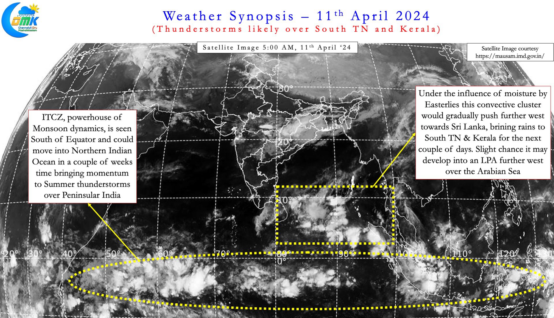


Starting today over the next three days or so South Tamil Nadu can look forward to some rains. In particular the districts of Thothukudi, Tirunelveli and Kanyakumari can receive at least one day of widespread moderate rains. Places along the Ghats like Manjolai may see one day of heavy rains as Easterlies push moisture into the valleys and get trapped. Kerala will also see some much needed rains over the next couple of days. This will bring a lot of relief to people who have been reeling under abnormal heat for the past few weeks. It is likely that gradually things can pick up on the summer thunderstorm front after this spell of rains. Fingers Crossed.
A bird in the hand is better than two in the bush. So time to look at this spell of rains even if it may not be widespread and benefit all. One should not forget climatologically places like Chennai do not see much rains around this time of the year. Even though the rains may not happen everywhere certainly it could bring down the heat until middle of next week. Weather models have been consistent for a few days now about Polling Day over Tamil Nadu being fairly hot. But before that it is time to enjoy a bit of much needed respite from the heat.