
Yesterday right on cue as Westerlies weakened indicating a lull phase in Monsoon parts of North TN saw intense thunderstorms over a few places. Places to the West of Chennai once again enjoyed the best spell. But in what could be considered a good sign Cheyyur right on the coast line to the South of Chennai got more than 8 cms while Pondicherry & Cuddalore aslo recorded moderate spell of rains late in the evening.

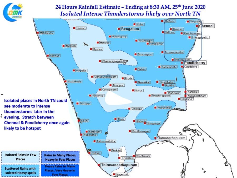
The UAC over South Bay is likely to provide conducive conditions for the thunderstorms to develop over most parts of Tamil Nadu today. With westerlies weakening and the UAC creating a pseudo Easterly phenomenon off the coast many places in North TN & South AP fall under the zone of wind instability. Additionally while parts of South TN is seeing some high clouds North TN is fairly clear from last evening’s remnant thunderstorms.
This could mean the convective trigger for thunderstorms to develop will be available for places in North TN & South AP. Once the thunderstorms develop the prevailing wind convergence provided by the UAC will give enough support for sustenance. As has been the case for the past couple of days we can expect slow moving thunderstorms today as well which could mean places that come under intense spell of thunderstorms.

Theoretically today represents the best chance for Chennai to complete its quota for the month of June as the stretch between Chennai & Pondicherry has the best chance for some high intensity thunderstorms in one or two places. But Chennai Rains has a mind of its own. Lets see what is in store for us.