
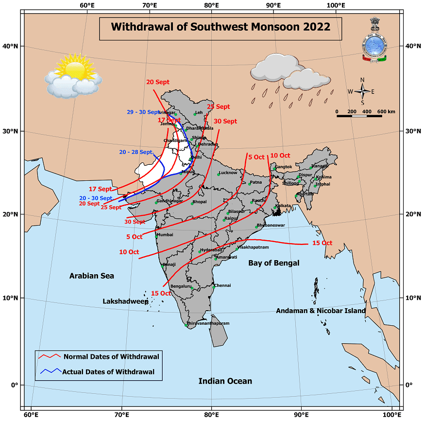
Yesterday officially the Southwest Monsoon season came to an end with an overall performance of 6.5% above average. IMD has four seasons for statistical convenience. January and February mark the winter season, March to May is considered as summer season while June to September is the Southwest Monsoon season and October to December being the post monsoon season. As we know the onset and withdrawal dates of both Southwest Monsoon & Northeast Monsoon do not follow the statistical dates, but it is necessary for IMD to maintain standardized seasonal dates in order to compare historical trends for analysis and research.
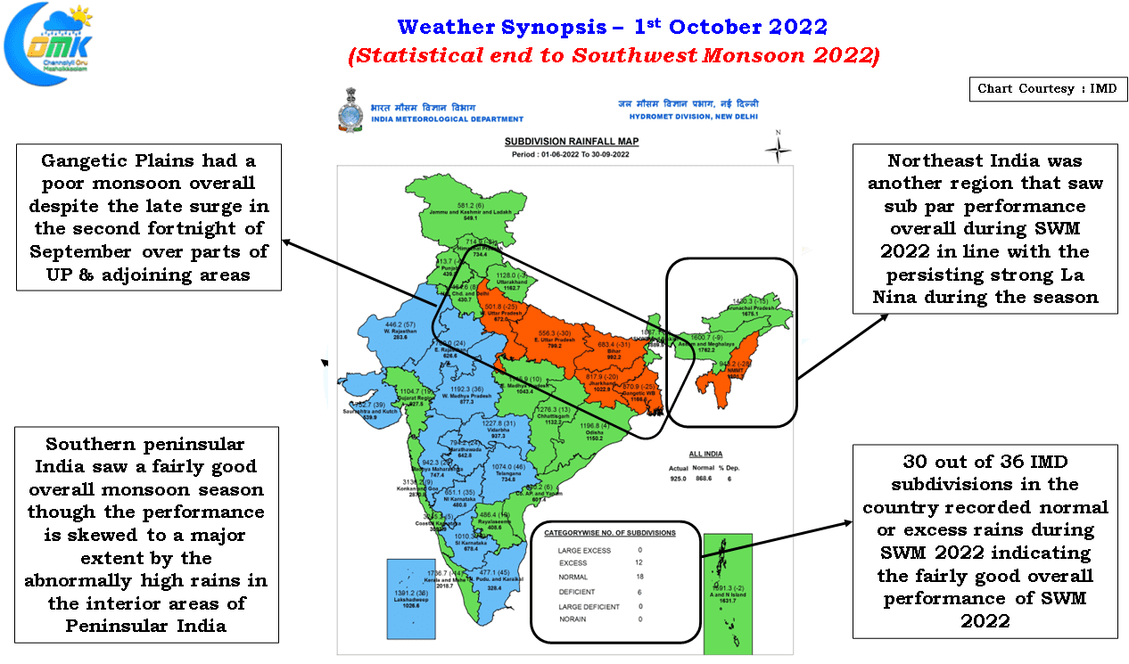
While overall the performance of Southwest Monsoon has ended positive pretty much the entire Gangetic plains ended up with sub par performance despite the strong end to the season during the second fortnight of September. It is interesting to note that 2022 Southwest Monsoon season despite having 67 low pressure days against the long term average of 57 low pressure days Gangetic Plains around UP ended up with deficit while areas south of Gangetic plains around Central India in MP & adjoining areas ended up with exces. Similarly most of Northeast India had a sub par performance which is a reflection of the strong control La Nina conditions had over the background state.
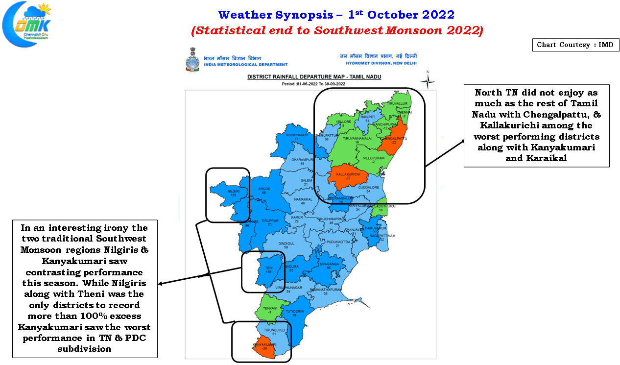
Closer home Tamil Nadu & PDC saw one of the best monsoon seasons in recent times ending overall at 477.1 mm the highest in more than 30 years. Nilgiris, Kanyakumari & parts of Coimbatore are the traditional monsoon zones in Tamil Nadu with bulk of the state being leeward areas. Among all the IMD obervatories in TN & PDC only four of them have recorded lower than the seasonal averages though one can say possibly only Karaikal could be considered as deficit with the season ending nearly 7 cms sharp against the long term average of nearly 30 cms. Interestingly while Nilgiris recorded more than twice the normal rains this year Kanyakumari was the worst performing district overall for TN & PDC. It remains to be seen if Northeast Monsoon will compensate some of the areas like North TN along with Kanyakumari, Karaikal & Tenkasi which saw sub par performance.
On the weather front the Noru remnant has entered Bay and is likely to become an LPA and travel over East India and Central India keeping the monsoon dynamics flowing for the next 7 to 10 days. This is transition season so despite a possible Low moving over the Indian Sub Continent its impact may not be as strong as say an LPA during July / August. But the circulation will surely keep the monsoon withdrawal under check for a few days though there is no worry yet over the onset of Northeast Monsoon.