
Beware the ides of March (JULIUS CAESAR ACT 1, SCENE 2)
Caesar: Who is it in the press that calls on me?
I hear a tongue shriller than all the music
Cry “Caesar!” Speak, Caesar is turn’d to hear.
Soothsayer: Beware the ides of March.
Caesar: What man is that?
Brutus: A soothsayer bids you beware the ides of March.
One of the most famous quotes in the Julius Caesar play written by William Shakespeare is “Beware the ides of March” where the soothsayer indicates about a threat to Caesar by mid of March. In a way Ides of March is a period of anticipation for weather bloggers when things slowly start to fall in place to set the wheels of motion in changing the seasonal wind regime.
Just like how summer checks in early over places along the west coast of Peninsular India due to the role played by dry land winds from the East convective thunderstorms also make a comeback first over these areas closer to Western Ghats & the Peninsular West Coast where line of wind discontinuity gets triggered first along with parts of the northern end of Eastern Ghats over Odisha & adjoining areas. Mango Showers / Coffee Showers / Cherry Blossom Showers / Veppasalanam / Kalbaishaki / Bordoisila they are called by different names as we move around the various parts of the Indian Sub Continent, but pre monsoon rains are triggered by a common factor, convective process triggered by the presence of a wind instability and aided by the day time heating through summer conditions.
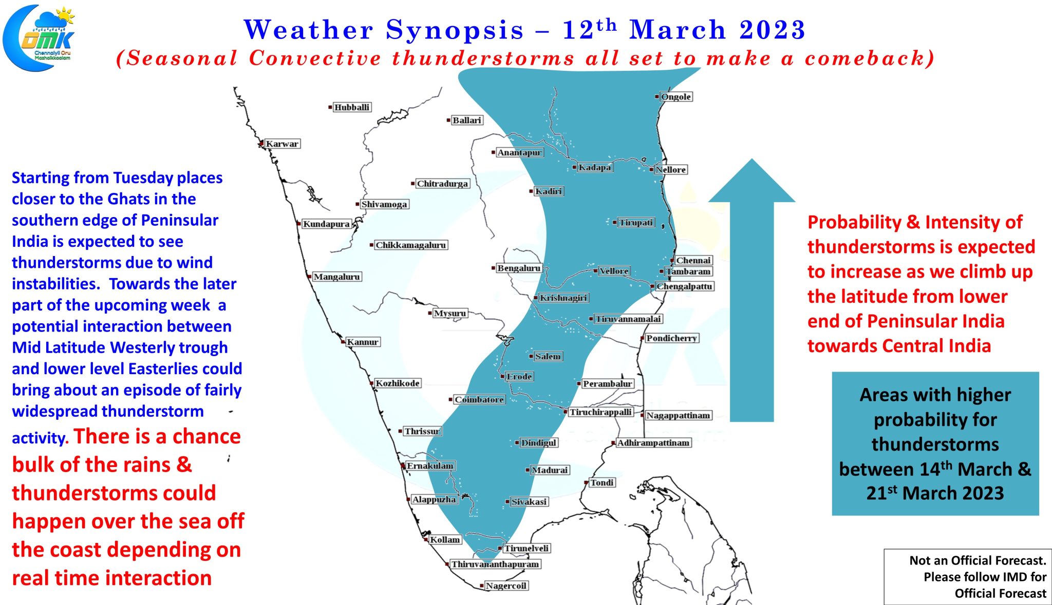
Line of Wind Discontinuity, an area where winds meet from opposite directions are the first indication of the changing wind regime. Weather models indicate in about 24 to 48 hours from now we may see the first instance of LWD conditions over Peninsular India though the first instance of Kal Baishaki has already happened over Odisha a couple of days back. Gradually as the Easterly winds weaken over Bay of Bengal the winds are expected to change directions over Peninsular India as well bringing more areas under wind instability triggering thunderstorms during the afternoon / evening hours through convective development. This is also the time when the chance for hailstorms are highest as well due to unstable atmospheric dynamics on account of changing seasons from dry to wet conditions as a prelude to the arrival of Southwest Monsoon.
While on the one hand the gradual shift in regime from this week will allow the return of thunderstorms and associated rains the event to keep a close watch on is expected to happen during the second half of the upcoming week. As usual this event which is an interaction between Mid Latitude Westerly Trough & lower level Easterlies is always the toughest one to pick up by global weather models with the actual impact zone potentially shifting by as large as few hundred kms depending on real time winds. Weather models are fairly consistent on this interaction happening around Peninsular India between 18th & 21st of March with the probability and intensity of thunderstorms increasing as we move further in an Northeasterly direction along Peninsular India. In principle the area between North TN & Odisha along the peninsular east coast is likely to be the broad hot spot though exact impact zone will be clearer closer to the event.
All in All as the heat quotient increases with the arrival of Summer over the Indian Sub Continent it is also time to track Veppasalanam Rains.