
It is that time of the year when weather bloggers across South India, particularly Tamil Nadu start behaving like Dads pacing themselves outside labor ward as he waits for his child to be born. Yes every year just before the onset of Northeast Monsoon there is a sense of expectation / butterflies in the stomach moment for weather bloggers as the window of Onset comes to within the next 24 to 48 hours. Tension builds as a lot of thoughts get into the minds about the intensity of onset, how would it compare to past onsets.
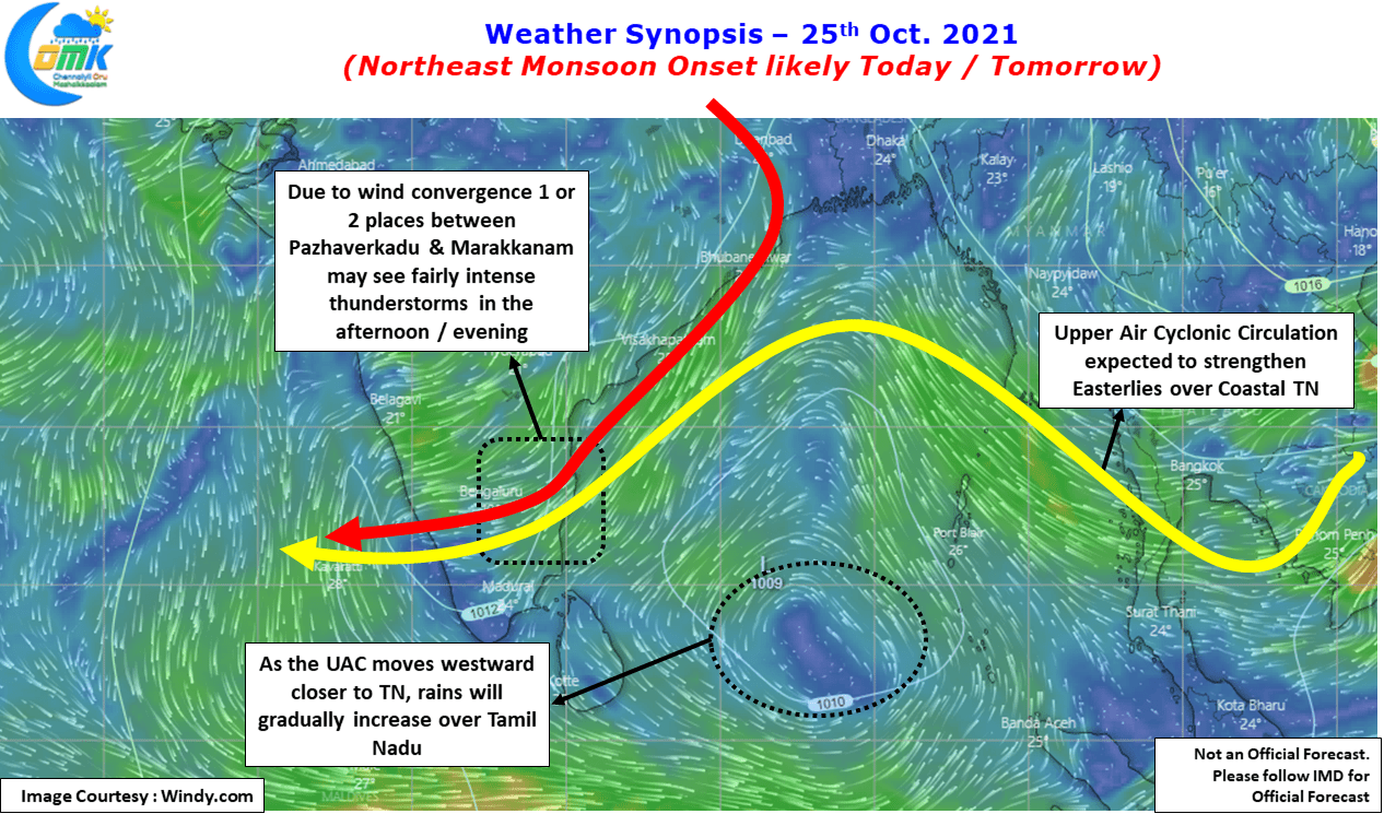
The satellite image indicates Northeast Monsoon may not be far away with Easterlies strengthening under the influence of an upper air cyclonic circulation seen over Bay of Bengal. The early morning high decibel action that hit Chennai & suburbs on Monday is a confirmation the Onset is a matter of another 24 hours or so. The wind charts show the reason for the high decibel action in the form of a wind convergence over coastal areas of Tamil Nadu.

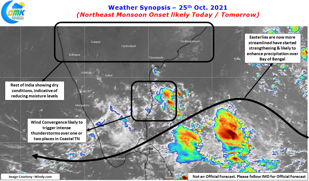
The UAC seen over Bay of Bengal has indeed to a great extent streamlined & strengthened the Easterlies compared to say 36 hours back. With weather models consistent on the circulation drifting west as it prevails coming closer to the coast of Tamil Nadu the Easterlies will further strengthen & the rains are expected to increase when the circulation comes closer.
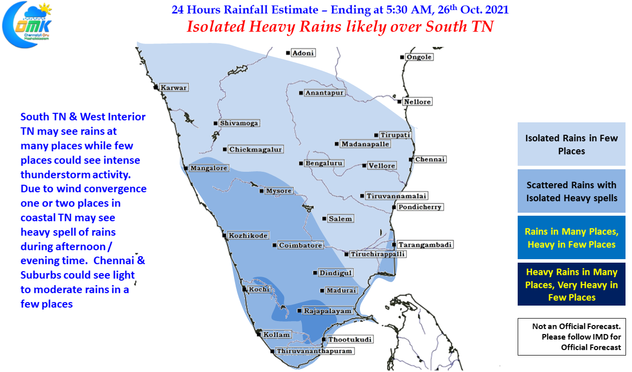
In the meanwhile today many places in South TN & West Interior TN may see moderate spell of rains while few places could see heavy spell of rains accompanied by lightning & thunder. Due to the wind convergence there is a chance for one or two places in coastal TN stretch between Pulicat & Marakkanam to come under intense thunderstorms during the afternoon / evening hours while Chennai & suburbs may see light to moderate rains in a few places.
All in All சென்னையில் ஒரு மழைக்காலம் இனிதாக துவங்க இருக்கிறது. Happy Monsooning.
ecmwf weeklies latest very worst for us
ecmwf improving every run
ECM increase intensity
Would say La Nina is holding firm in Tropics and anticyclone over Indo is too strongly holding overriding MJO suppressive phase.
Looks like after long time both atmosphere and ocean are in sync this year unlike 2016 where atmosphere acted like nino in spite of healthy Nina in Ocean?
Slowly ECM favouring deepening of SW BOB system and losing interest in intensification of SCS pulse which is entering BOB after 72hrs
What is ur view will scs pulse near tn coast?
I’m not able to find out who liked the comments. Is there anyway to find out?
No. Can’t find
You will get one like definitely as a default from me ;))
Haha.. Got it.
Same will be there for you from my side 🙂
Imagine MJO in IO. Then. We may get a good period of rainfall in mid nov
You expect MJO in IO only in mid Nov ?
looks like mjo will stall in IO and models forecast of quick exit from IO may not happen?
Tropics will reestablish in Nina circulation.
mid latitudes to stay quiet due to strong WC?
Mid latitudes may throw some disturbance if any rossby waves or SPCZ is ignited due to warm waters. I can say occasional
GFS till 30th🔥 🔥
icon till 30th 🔥 🔥
Ecmf forecast ji
11.15pm ecm run
Snowfall till morning in Himachal pradesh. Under the influence of Western disturbance:
Gondla – 15cm
Hansa – 5cm
Kadrala – 5cm
Keylong – 3cm
pondy annual rains till now-117cm(normal 134cm). So only 17cms required before 31st dec.
oct rains-218.6mm(avg oct rains 255.8mm). Remaining 663.4mm required before 31st dec for normal nem.
Jason Nicholls calling for SW BOB system to attain Depression status.
Can it slowly move towards ntn and sap coast as speculated before?
No.
Chances of stalling are quite less due to strong and no competing ridges.
If it does, it will attain major intensity due to abnormally high SST off NTN/SAP coasts.
SST off TN coast showing abnormal and very significant warming. 30-31C SST spread over Cuddalore-Nellore stretch.
but doubtful of ICOn solution. Ridges are strong which should give way to fast moving system but nevertheless coastal TN in for significant wet spell in coming days with 28th-1st Nov period looking very good.
Verithanam mode ah ,😁
Will remind people of 2005.
ICON 12Z :
LPA stalling off TN coast for 4days resulting in massive rains for coastal TN.
Many models expecting massive easterly surge over TN coast due to the system.
SoI think coastal TN should be prepared for very heavy rains in the coming days.
Yes. Its going to be a significant spell.
Favourable atmosphere provided by Nina and planetary waves, ridge placed north of the system will help it to become good rain bearing system.
Rain not yet started
After midnight?
Deesa, Gujarat region & Khajuraho,Madhya pradesh : 34.6c . Highest in the country today
So early ?? we are just in october
Is this true? Mettur Dam crossed 100ft mark already? Looks like some incorrect data in the Inflows of yesterday’s one.
http://www.metturdiary.com/p/mettur-dam-water-level-history.html
Mettur Dam Water Level Live Status
On 25-10-2021: 101.050/120 அடி/Feet
Inflow: 21,390 கன அடி/Cusecs
Outflow: 550 கன அடி/Cusecs
Available Water: 66.208/93.47 T.M.C
Water Level: Increasing
Heavily pouring here for past 20 mins
Daily rains for you!
Yearly avg is above 100 cm already?!
Avlo laam illai.. Around 60-70cms i think
Here it should be half of that
After successfully installing one more PWS at Thiruvanmiyur this August, now there is yet another Professional Weather Station which is up and running at Korattur/Padi owned by Novak Nole (Shiva) ,very happy to have installed it exactly on the day of NEM onset 2021 https://cdn.statically.io/twemoji/1f603.svg , here is hoping the station gets going from tonight itself with the grace of almighty my dear god, I am really excited to see many private weather stations at Chennai , looks like soon our own data can be used as ready reckoner in the future to train data,analyse and predict local conditions much better and use it for developing local WRF kind models https://cdn.statically.io/twemoji/1f60d.svg
https://www.wunderground.com/dashboard/pws/ICHENN41
Wow. Super. So Marketing Director of Misol has been working hard
Looks like my dear brother Thiruvanmiyur Thirudans has informed you about this new job title https://cdn.statically.io/twemoji/1f602.svg
ICON India Director , MISOL India Marketing and Customer affairs and recently I believe has even taken up a honorary posting in the IMD . Well Well
Novakji also one of my well-wisher
Comments are displayed only after logged in
thats the idea to reduce load on server
Ok fine………
Upcoming system track?
The sky doesn’t look like monsoon onset phase, hazy
Hazy skies normally happen with Northerly winds, so we are still having little bit of Northerly winds
Pleasant NE Winds blowing over Chennai…Has nicely cooled down the city…Beauty of our monsoon winds
Maximum track on weekly basis. That will be ideal
Better to go with 3 or 4 days at a time
Delhi Safdurjung – 122mm
Delhi Palam – 61.2mm
Since Oct 1st
Delhi overall has had a very good year
Rainfall in Delhi (in cm). Under the influence of western disturbance:
Pusa 4,
Lodi Road, Delhi Ridge, Safdarjung, Dhansa, Superintendent of Police Mayur Vihar and Delhi University 3 each,
Rashtrapati Bhavan 2,
Ayanagar and Pitampura 1 each
Rainfall in himachal pradesh(in cm):
————————————————
Rajgarh 8,
Kasauli 7,
Naina Davi 5,
Amb and Jhandutta 4 each,
Dharampur, Solan, Berthin, Tissa, Hamirpur, Aghar, Kothi, Pachhar,
Renuka/Dadhou, Baldwara, RL BBMB, Kandaghat and Manali 3 each,
Bhoranj, Nadaun, Paonta, Kahu, Mere (Barsar), Sujanpur Tira, Bangana_R,
Hamirpur, Una Rampur and Una 2 each,
Gondla, Sangraha, Sundernagar, Dehra Gopipur, Nurpur/Jasur, Jubbal, Kotkhai, Shimla, Bilaspur Sadar, ,
Dharamshala, Bharmour, Seo Bagh, Dharamsala, Bharari, Rampur Busher, Narkanda, Tinder, Shimla, Arki, Rohru, Nagrota Surian, Dalhousie Alha,
Baijnath, Guler, Kangra Aero, Palampur, Nichar, Banjar and Kufri 1 each
Rainfall in Punjab(in cm):
———————————————————
Khanna and Nabha 10 each,
Bhadson 7,
Samana 5,
Rajpura, Anandpur Sahib and Sirhind 4 each,
Fatehgarh Sahib, Amloh, Payal and Patiala 3 each,
Ropar, Balachaur, Rajpura, Nangal and Sangrur 2 each,
Derabassi, Kharar and Tsunam 1 each.
Rainfall in Haryana(in cm). Under the influence of western disturbance:
Pratapnagar 7,
Beri and Tajewala 5 each,
Dadupur and Kalka 4 each,
Karnal, Chandigarh, Panchkula, Bilaspur and Panchkula 3 each,
Jhahar, Badli, Bahadurgarh and Sonipat 2 each,
Samalkha, Dadri, Ambala, Morni, Bapoli, Jagadhri , Mahendragarh, Nilokheri, Ambala, Gurgaon, Barwala, Raipur
Rani, Israna, Chhachhrauli and Radaur 1 each
Sri regarding withdrawal delay is what I had pointed in my post earlier too
That is during mid monsoon last few years we are seeing Asia Pacific Jet which should not happen in a monsoon time.
This in subsequent month delays SWM withdrawal by covering up break period.
So be default your NEM season will also change, it is not going to be a case where because SWM withdraws late NEM season is curtailed
Yeah monsoon is changing
in this commenting platform, we can able to see to whom we are replying❤️❤️🔥…in Disqus we don’t see such thing….if we come back after a while we ll see just train of comments which we couldn’t identify to whom who replied…I ll assume myself , this reply for him,that one for him like😂😂
ராஜபாளையம், சிவகாசி, விருதுநகர் எல்லா பகுதிகளிலும் இன்று காலை முதல் சரியான வெய்யில். இத்தினி கூட காற்று க்கு மரங்கள் ஆடவில்லை. வேர்த்துக் கொட்டியதில் சட்டை துணியெல்லாம் கசகசப்பு. அநேகமாக மழை வரவேண்டும்.
Thats what i too felt in my native but no rains till now
Today is a very dull day!
Monsoon Onset has been announced that is why
Ha ha true..
Northerlies giving super chill winds here making it like December month
gusty Winds in ecr road
Icon latest till 28th night
Now ICON increased the precipitation 🤔🤔
Every model now caving into GFS way..
yes, but gfs not reduced the precipitation some delay push the system
Yeah it also expecting the dryline storms to impact SAP more than NTN
May be that is also a reason for reduced precipitation
GFS latest till 28th night
Raining heavily in Trivandrum for last 30minutes!
Super sir, so NEM onset has happened for you also
Yes, a short blast!
just drizzling near kazhakuttam area…. pretty dark though..
If one were to plot the Withdrawal completion dates of Southwest Monsoon as an anomaly against 15th October the traditional withdrawal date then there is a clear delaying trend for the past two decades or so.
That’s why the IMD seems to have pushed their traditional onset date to 21st-22nd Oct in their recent report
It might get shifted towards end November finally I feel
Namba monsoon period already rombha chinadhu idhula SWM vera extend avudhu
This year NEM going to be a very tricky one to track it seems..models are struggling to pick MJO behavior..we may end up with many surprises..it can be 2015 returns or worst like 2016 or balanced like 2020..going to be a very thrilling days ahead..
When walker cell is bit stronger models mess up MJO
There seems to be mostly 2 extremes of forecasts so far this year..one group is predicting STN n Central TN to get most rainfall..another favours NTN n SAP…I believe Delta along with NTN n SAP is for maximum rains
The truth lies somewhere in between
Perfect right
It has to be delta..the show stopper..
1600 + 400 / 2 = 1000mm
Rain in kk dist
Good to see consensus among models on SW BOB system. ECM should increase intensity in upcoming runs.
Guest11k to Guest111k ;))
Yeah. Like from Ramirao to RajaDao
Share my article to guest
He has been promoted thanks to the change in commenting platform
Is it your new username?, “guest 111k”
Kelvin wave entered
Hope’s alive
so related with mjo ready to enter? correct
mjo stay at western hemisphere continue
MJO just seems to be in WHEM. The truth is MJO is dead
It correlates with increased WWB and convection over IO.
Vnr narrowed down the deficit to -41%
But definitely not enough!
I feel it will surely end NEM with positive anomaly
That’s great anna!
Some catchments are cleant and restored this time..the monsoon rains can bring back the glory to the catchments..
testing by uploading image
Nothing to see indeed actually
IMD announced NEM onset today
When I will be able to see a onset like 2014
Strong breeze from the east in Pondy. Rolling waves seen in Bay..NEM is here
Image test. IMD Announces onset
Easterly winds have commenced over TN coast.
Hello everyone,
My first comment from new account.
welcome guest ji to the new commenting platform❤️🙏
11 –> 111 ???🙄
Thanks.
guest11k username taken by someone else. So had to had one more 1 in my disqus idname 🙂
Hi Guest ,nice to see you back , Nelson -111?
guest11k username already exists on wordpress. So got no other choice but to make it as 111k 🙂
So your name now is guest111k
yes. For wordpress account.
For disqus it’s the earlier one only.
Welcome back guest!😃, Nice to see you back.
Better it is declared on auspicious day
Yesterday was an auspicious day illai, today also??
Today also Sir
Earlier day super
Rainfall till morning:
Solan – 33.6mm
Sundernagar – 12.8mm
Una – 16.8mm
Manali – 24mm
Shimla – 10.4mm
Bilaspur – 13mm
chandigarh – 29.7mm
chandigarh AP – 28.6mm
Ambala – 30.2mm
Karnal – 32.2mm
Delhi Safdarjung – 27.5mm
Delhi Lodi Road – 29.4mm
Delhi Ridge – 27.8mm
Delhi ayanagar – 14mm
Aligarh uttar pradesh – 50.6mm
Muzaffarnagar uttar pradesh – 15.8mm
Meerut uttar pradesh – 11.6mm
IMD :
♦ A cyclonic circulation is likely to develop over Southeast Bay of Bengal & neighbourhood by tomorrow. It is likely to move westwards. Under its influence, a Low Pressure Area is likely to form over central parts of South Bay of Bengal during subsequent 48 hours.
IMD:
the northeast monsoon
rains has commenced over extreme south peninsular India today, the 25th October 2021.
onset by IMD doesnt mean actual ‘Onset’ . Dont know if IMD will dare to do the same for swm in Delhi.
Dubakkor monsoonukku avaluthan mariyathai
We have seen so many onsets
Vidunga !!!
Dubakoor Monsoon ah , you will face the wrath for stating this ,wait and watch 🤣😂
Big hint set😀😁😂
IMD does not differentiate SWM & NEM, many times SWM onset also has seen surprising declarations
long live imd
Delhi-NCR is different ,Rest of India is different , SWM declared over Kerala ,the first port of entry into Indian Mainland on a superb sunny day as well this year
criteria has become an excuse to declare onset
bright sunshine in Adam
New message not shown me first how to select and view the newest message on top
That’s due to pinned message by admin !!
So others comments appear below, it’s like featured comment in Disqus !!!
Ok got it thanks for your reply
Welcome Northeast Monsoon, IMD announces SWM withdrawal & NEM onset expected tomorrow
Today winds are more streamlined from NE while yesterday it was from North , our bloggers’ weather stations picks the transition at surface level beautifully
Surface level winds from ne can fell it when I went out
Very high humidity, NEM is not far away
Good morning to all ❤️.
Have a nice day 😊.
Surface winds and low clouds from NE !!!
Karipati 40 mm
Many places 30/40 km around sivakasi should have got 5 cm in last 3 days widespread
Could see water puddles on the way to my native from chennai
Alakkode 91mm
Payyavoor 73
Irikkur 59
Mannarkad 57
Perinthalmanna 43
Peermade 42
Mattannur 40
Kuttiyaidi 40
Sholayar 40
Panniyoor 30
Kanjirappuzha 30
Angadippuram 23.4
Enamakkal 21
Classic NEM thunderstorms closer to the Western Ghats
Yes, coastal areas perfectly dry.
33.3 mm here from yesterday afternoon spells !!!!
Posting a direct image link
https://www.wxcharts.com/charts/gfs/india/charts/overview_20211025_00_069.jpg
Min temperature recorded today:
Darjeeling – 11c
Kalimpong – 15c
Purulia – 19.1c
Siliguri – 19c
Imphal – 15c
Daltonganj jharkhand – 19.3c
Jamshedpur jharkhand – 19.6c
Ranchi jharkhand – 17.6c
Gaya bihar – 19.3c
Jaipur rajasthan – 19c
Keonjhargarh orissa – 17.4c
Hirakud orissa – 19.4c
Jharsuguda orissa – 19.6c
Gangtok sikkim – 13.5c
Tadong sikkim – 14.5c
SST off NTN and SAP coasts hovering at 30-31c
Parts of erode district pounded yesterday.kavundapadi again 63 mm.annual nearing 1300mm.
Wow. 1300 mm is higher than some of the annual rains of coastal areas
Yes ji.massive year for erode district.most of the stations inching towards 100 cm
Today’s post exactly speak about the weather lover’s mind voice, there is always a fever which will accompany the weather watchers especially during NEM as the gaint BOB starts waking up!! Lets hope for the best NEM for all!!
25.2 mm from the early mornings rains at Anna Nagar. The sound & light show was fairly intense as Ramanan had mentioned in yesterday’s post
0mm at the Bay Branch
NEM is not yet on
Good Morning all, a lot of you might be wondering why the Image upload feature has been disabled. Earlier with Disqus the comments & Images were hosted in their platform so the load on our server was reduced, now with native comments & ajax the load has increased on our server. https://ibb.co/WPBZrpQ while we work out a solution to reduce the load temporarily we are disabling direct image upload. Meanwhile you can upload images to third party hosting services & paste the link which will allow you to show the images along with your comments. Thanks for understanding.
Or also just posting a direct image link will display instead of attaching it
Finally managed to log in 🙂
I have noticed that clicking images on COMK sometimes takes me through a different website. In this comment there is a link to ibb[dot]co. Is some plugin or code doing some unnecessary things either on your website or PC ? I am fairly certain that it is not a problem at my end.
It was only to show using 3rd party image hosting services, will surely find a way to upload images in our server, please bear for a while
No problem. I was just worried if it was a safety issue for you.