
Back in 2017 when even IMD did not issue seasonal update for NEM our first outlook was put up. Initially the outlooks were mostly based on seasonal OLR charts or Hovmollers from CFS. Gradually the availability of ECMWF seasonal forecasts provided another tool to look into while making seasonal outlooks. Over time these seasonal outlooks became a regular feature among the weather blogging community. So it is now time for this year’s Northeast Monsoon outlook.
Last year for the first time we attempted to identify closest analog years based on prevailing atmospheric and oceanic state. Through these analog years the likely pattern for the year was arrived. This year for NEM 2025 also a similar approach has been taken. But this year’s outlook has an extra dimension added to the seasonal outlook. A statistical estimate of district wise seasonal rainfall tally based on the identified analog years. It becomes essential to express our thanks to IMD for making available gridded rainfall data. We have used the past years gridded rainfall data set from IMD to estimate 2025 rainfall.
The methodology involved reading geospatial grid data available from IMD dataset.
- It includes the geographic coordinates and precipitation data which is embedded on a rasterized geojson to map the precipitation onto the grids.
- Next an operation called masking was performed to apply it to the region of interest (ROI). Here being South Peninsular India.
- For areas with missing data, available data for those districts/localities was fed to fill in the spatial grids to address missing grid values.
- Grid fine tuning was performed and refined Contour heat map forecasts were developed with defined precipitation scales.
- Using the identified analog years (through various similarity metrics estimations) as input, geospatial district level forecasts were generated using 3 scenarios (equal weight, exponential weight & user defined weight approach) and finally a mix of all these scenarios was used to create a blend forecast that likely serves as a robust geospatial forecast analytics tool to implement in the years to come!
- We believe 2025 will serve as the testbed to this multi-layered approach. Based on observed real time precipitation, any hyperparameters will be tuned appropriately to appropriately fit the monsoon dynamics!
It is a new frontier for the weather blogging community to provide district-level rainfall estimate for the season. A lot of credit for developing this goes to வையை வேங்கடரமணன். A heartfelt thanks to him for taking time off from his busy work schedule for this cause. Special mention to Prasanna Venkataraman as well for being a sounding board during this exercise.

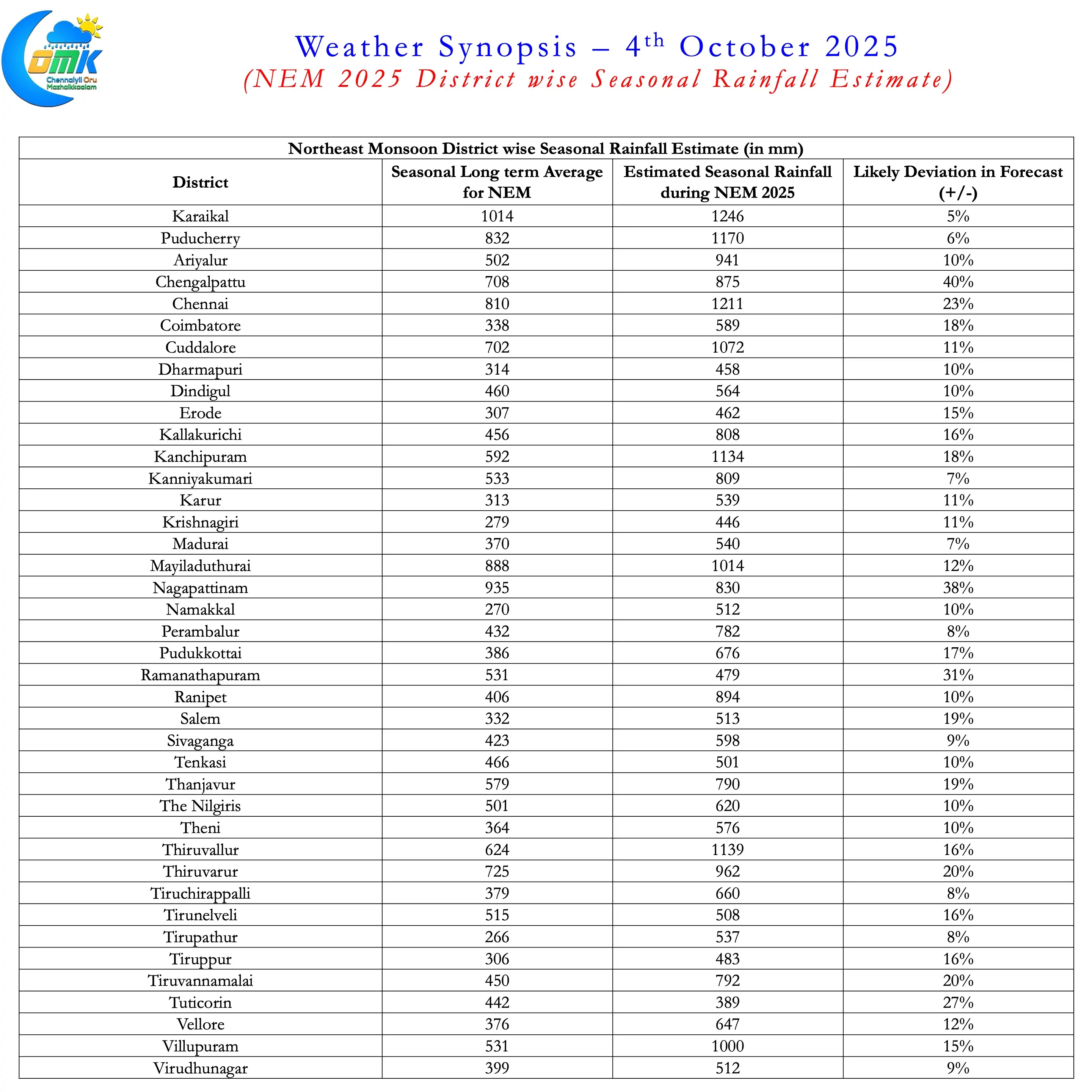
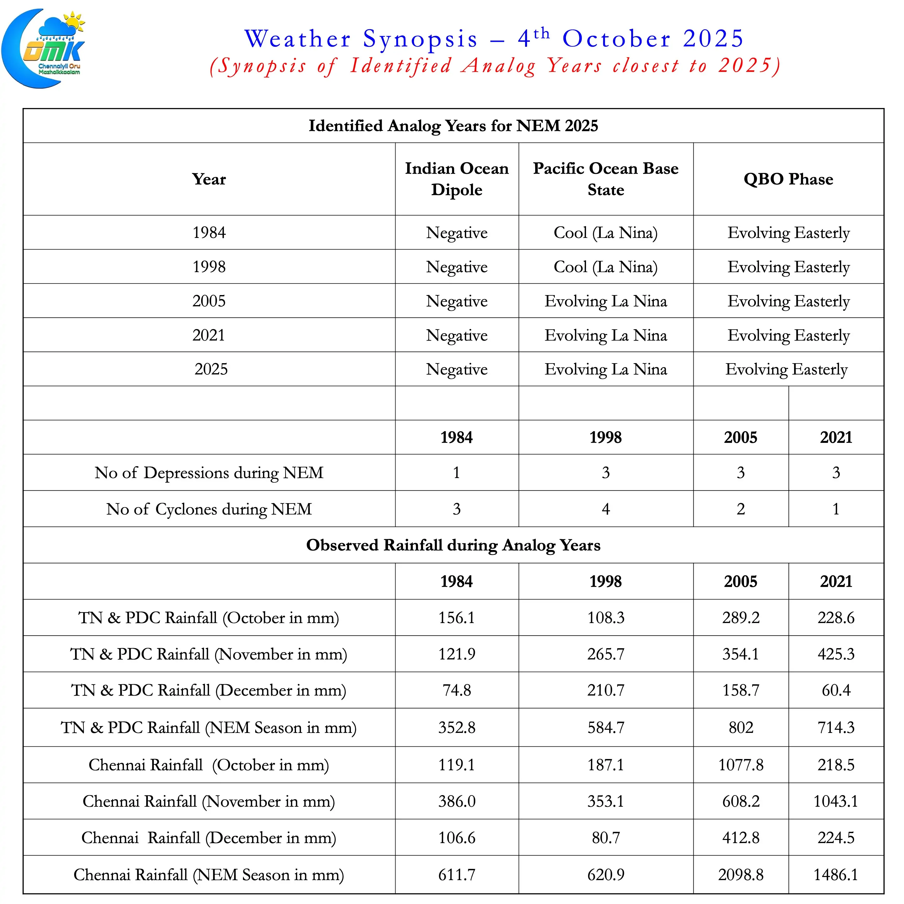
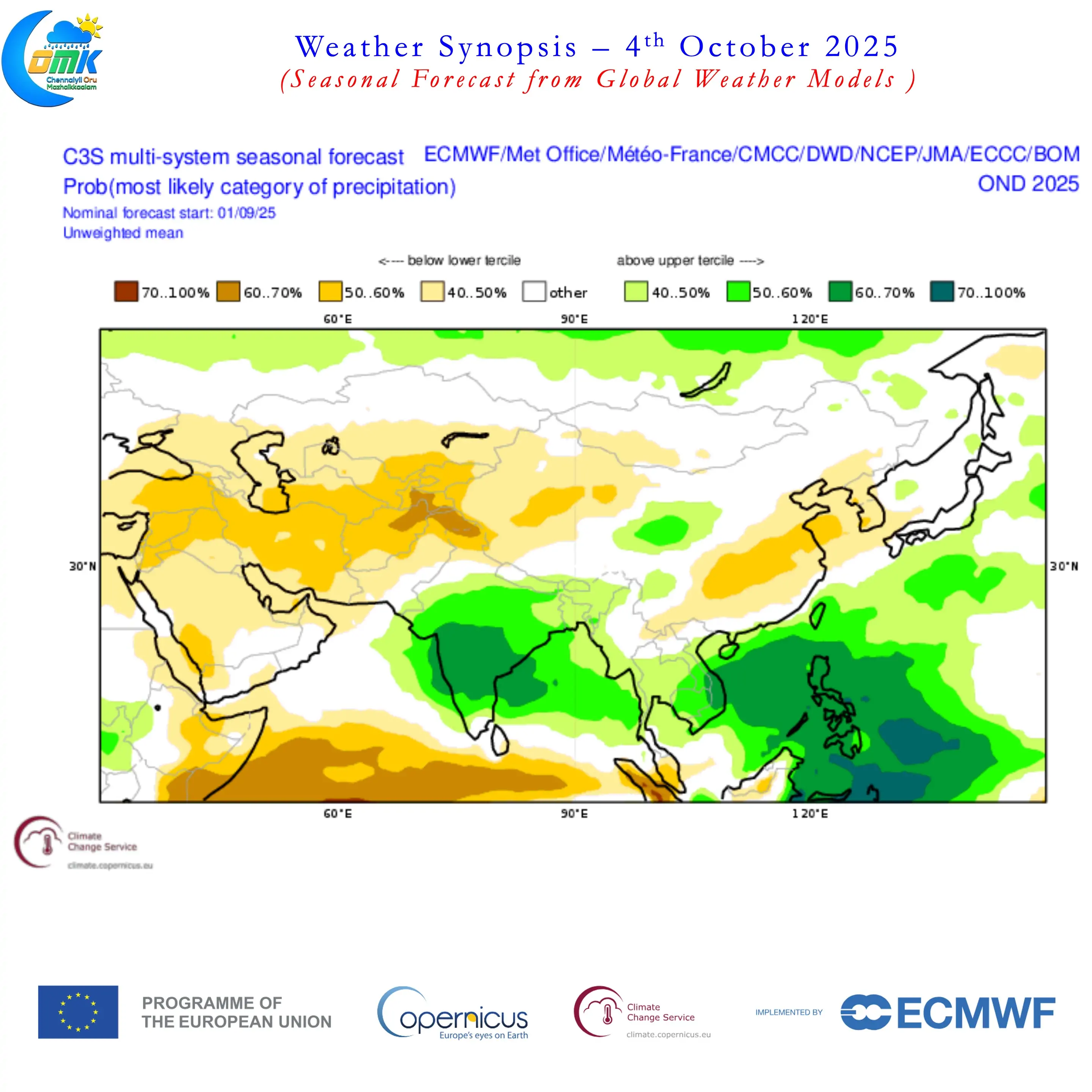
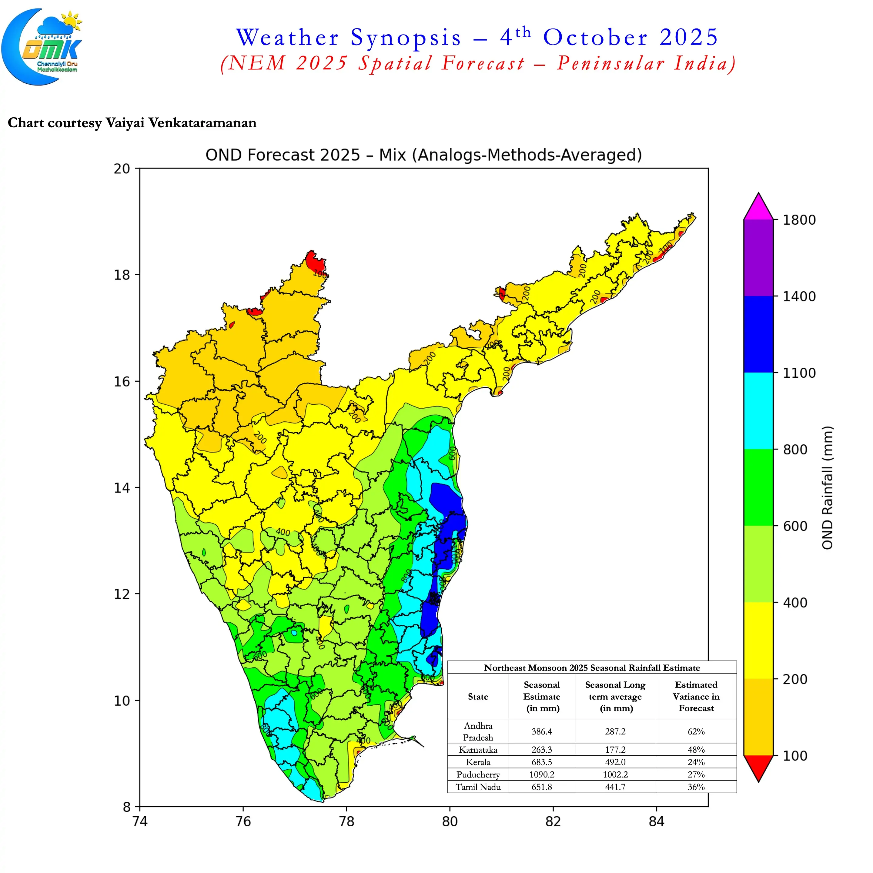
Every day is a new learning for weather bloggers. This new experiment is also no different. As the season unfolds we will be like students waiting to see exam results. The table features the district wise rainfall estimate for the season with a margin for error. Some districts show tighter alignment reflecting in smaller error. While a few like Chengalpattu, Nagapattinam seem to have seen contrasting seasons during the identified years. The state seasonal rainfall estimate shows a higher margin for error but we have added the same to complete the perspective. For example AP’s rainfall performance during Northeast Monsoon period is determined more by the movement of tropical disturbances rather than core monsoon dynamics explains the high variance.
The overall synopsis of NEM 2025 Outlook is as below
- The identified analog years are 1984, 1998, 2005, and 2021. All these years saw Cool Pacific (La Nina or evolving Nina) along withe negative IOD conditions. Additionally these years also saw evolving Easterly Phase of QBO.
- A above normal year likely for most parts of Peninsular India. There is a high chance for Tamil Nadu & Pondicherry to record a 2nd successive excess year.
- Northeast Monsoon 2025 has the potential to become exceptional if the 2nd half of monsoon remains strong.
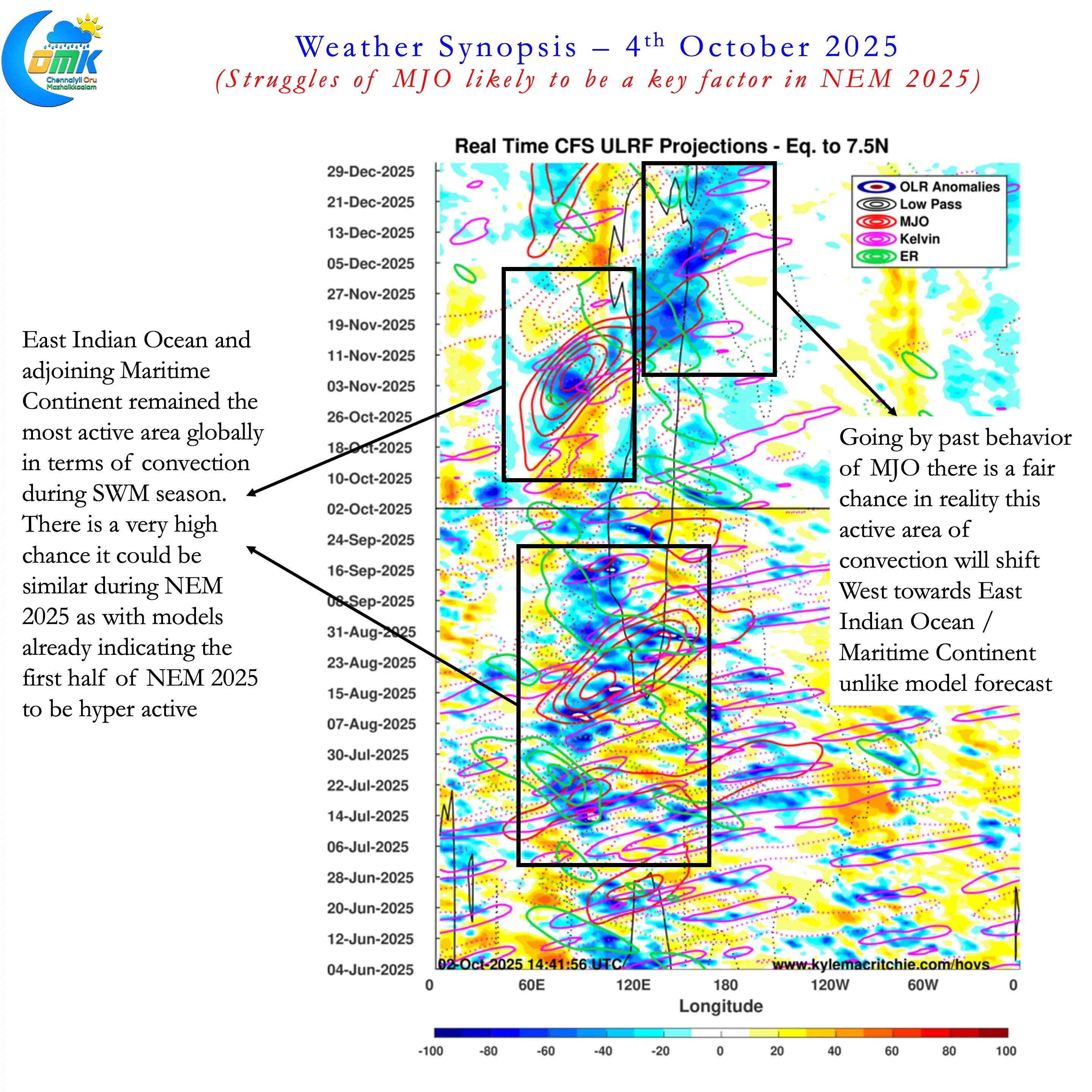
- NEM 2025 onset is likely to be around 17th October (+/- 3 days). A fairly strong onset phase is likely under favourable conditions. A fresh MJO pulse over Indian Ocean will set the stage for a classic Onset.
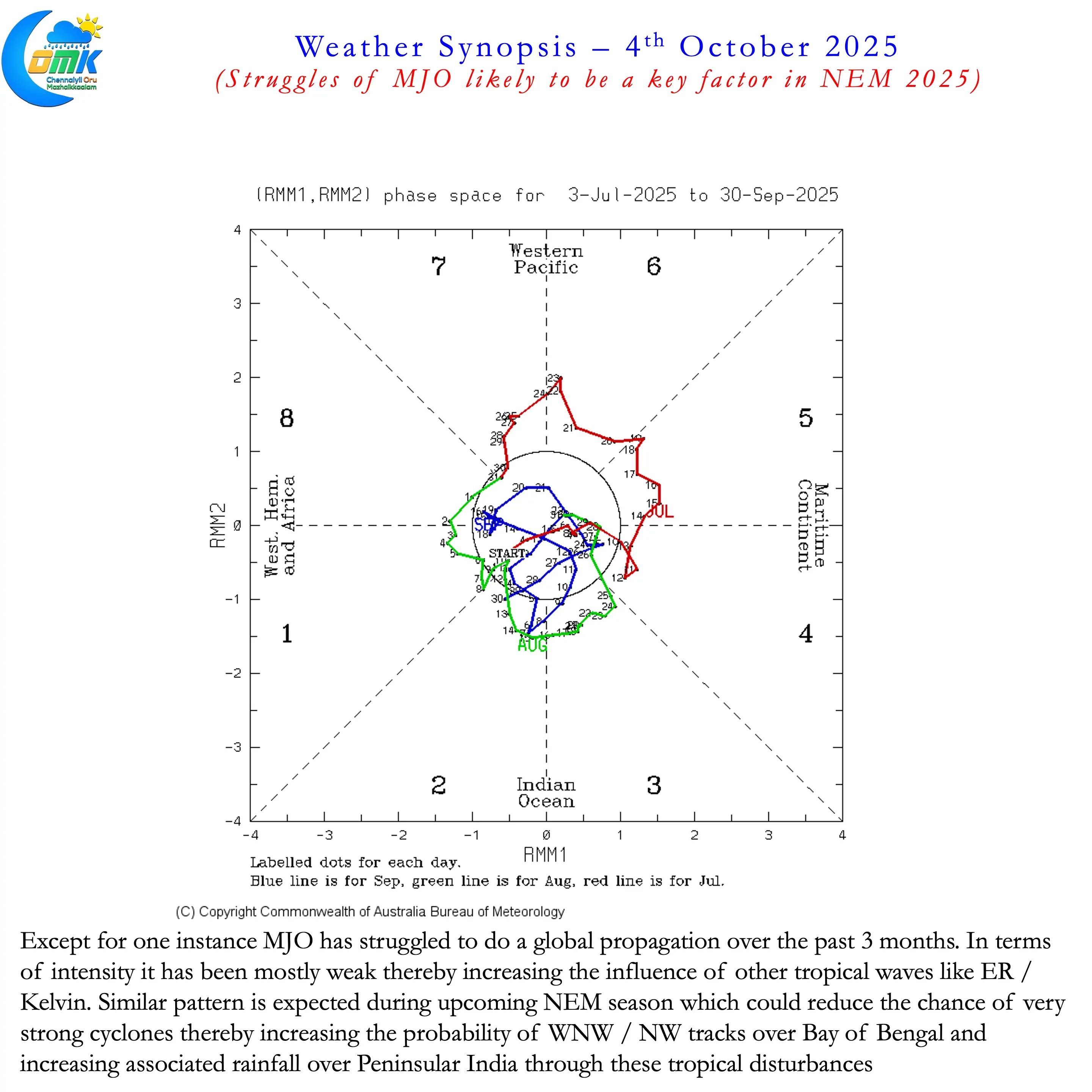
- MJO is likely to remain a more passive player during NEM 2025 as was the case during Southwest Monsoon this year. This could bring weaker / moderate disturbances with a more pronounced WNW / NW track.
- With Indo Pacific Warm Pool remaining warm around EIO and adjoining oceans of MTC there is a high chance for MJO to stay longer in this region during NEM. This could potentially push regular pulses into Bay of Bengal from South China Sea.
- Additionally this would also allow other tropical waves like ER and Kelvin to play a more pronounced role. This traditionally favours Peninsular India in terms of rainfall pattern.
- Overall there could be 7 to 9 tropical disturbances (Low Pressure or stronger) during the season.
- Northeast Monsoon 2025 may see 2 / 3 cyclones of which at least one could impact Tamil Nadu directly. This year there is less likelihood of strong cyclones during Northeast Monsoon.
- Though North Indian Ocean is relatively cooler than the previous years large swathes are still 28°C or warmer. This once again increases the risk of extreme rainfall events when tropical disturbances come closer to the Peninsular Coast.
- With higher probability for WNW / NW movement we may see disturbances move across Peninsular India towards Arabian sea. This could mean interior areas of Peninsular India is also likely to see a very good monsoon year. We have seen the impact of west moving Cyclone Fengal over interior areas last year. Similarly both Palar and Thenpennai carried 1 lakh cusecs during November 2021 under the influence of Depression BOB06.
- Overall NEM 2025 is less likely to fail with a high probability of above normal / excess year. If MJO continues its struggle against base state during 2nd half of NEM then we should be prepared for potential flooding events across most parts of Peninsular India.