
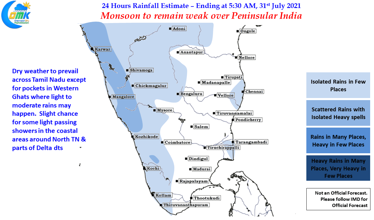
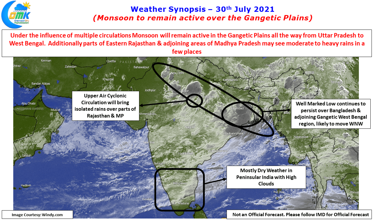
A Well Marked Low embedded in the Monsoon trough, over Bangladesh & adjoining parts of Gangetic West Bengal, that is near normal position over the Eastern end & slightly North of Normal position in the Western End. Another circulation in the trough over Uttar Pradesh bringing heavy rains over parts of Central India & North India. Many must be wondering why Peninsular India is not seeing much rainfall activity. While the leeward areas of Peninsular India like the East Coast of Tamil Nadu, Interior areas of AP & Karnataka etc does not score much during active monsoon conditions even West Coast is not seeing widespread rains forget widespread heavy rains. It could be intriguing to many who may wonder why is it so?
The answer lies in Monsoon Intraseasonal Oscillations (MISO) as its popularly called as a concept was advocated by one of the foremost Monsoon experts in recent times Prof. Sulochana Gadgil. As often remarked Factors that govern factors are basically discoveries. They have existed for many centuries, for e.g. Monsoon as a word derives its origins from the Arabic word Mausim which means weather. Similarly if one were to look at concepts like Hadley Cell or for that matter Walker Circulation & SOI which is credited with Gilbert Walker. For that matter though meteorologists are credited with the discovery of El Nino / La Nina it was the South American fisherman who first identified this weather pattern associated with changing fish availability for them. MISO is one such concept that has been identified as a key influencer of Monsoon Rainfall in the Indian Subcontient.

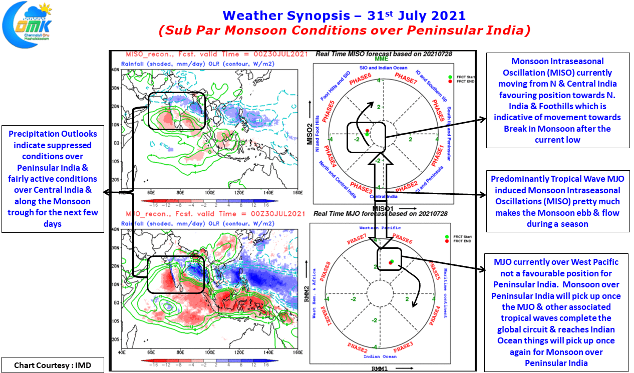
Entwined with the movement of MJO across the globe MISO indicates the Northward propagation of Monsoon Oscillation, which eventually culminates in the Break in Monsoon conditions. Just like Active & Suppressed conditions triggered by MJO’s movement it has been identified MISO also could trigger its own active & suppressed conditions over the Indian Sub Continent. Currently the MISO is on its Northward journey towards the foot hills of Himalayas hence despite a Well Marked Low over Gangetic West Bengal the rains have not been heavy over Peninsular India. Once MJO completes its global circuit & starts as a fresh pulse over Indian Ocean in couple of weeks time we can see monsoon once again pick up over Peninsular India.
In the meanwhile though as the trough moves to foothills we might see thunderstorms over the leeward sides return gradually, though it will still require support from tropical waves for enhanced thunderstorm activity. Weather models indicate in a weeks time Peninsular India should benefit from the arrival of a wave or two to benefit the leeward side before shifting attention to Monsoon over the west coast.