
There is an Old Saying “முதல் கோணல் முற்றிலும் கோணல்”, Monsoon 2019 started on a weak wicket with a delayed onset pretty much setting the trend so far. It is indeed not a good reading to see core Southwest Monsoon regions like Kerala, Coastal Karnataka, Konkan reeling under very high deficits with the 3rd week of June pretty much coming to a close.
Thiruvananthapuram is the only district in Kerala showing a positive anomaly as things stand while over neighbouring Karnataka all the three coastal districts along with Hassan & Kodagu, critical for Cauvery Basin, are all in deficit or worse zone. Today is the 3rd in our COMK SWM series were we give a slightly long term inference on the monsoon prospects. The previous two posts were put out on 31st May & 20th May. Through both the posts we have been mentioning about how Monsoon 2019 is likely to be weak during the early phases.

It appears Monsoon 2019 is unlikely to flip over any time soon going by the look of how long term OLR Charts put out by Weather Models. The arrival of MJO into Indian Ocean during late May / early June resulted in some momentum bringing forth the Monsoon Onset along with Cyclone Vayu. With MJO currently over the Maritime Continent we can expect some bit of positive momentum for the Bay branch, which is reflected in the upcoming LPA. We could possibly see a bit of Monsoon flourish in the coming few days but would it cover up the June deficit remains a key question.
On the slightly longer front as MJO exits Maritime continent and makes a slow progress over Pacific Ocean the Indian Sub Continent will move into suppressed phase and we need to see if Monsoon can overcome the odds and picks up some pace in what is a very critical month.

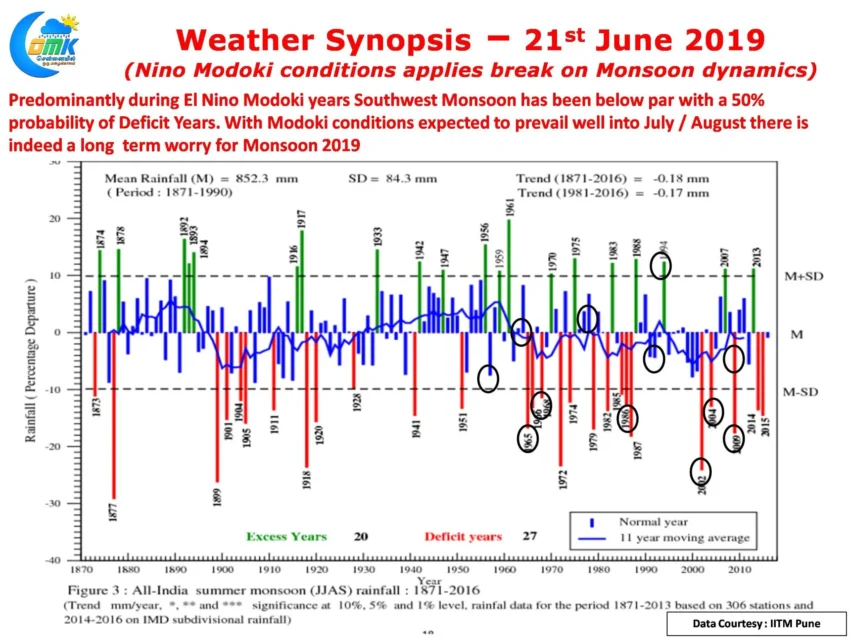
The current Monsoon dynamics resemble a racing car running with hand brakes on reflected by the stuttering start so far. The poor monsoon dynamics could be traced to the prevailing Modoki flavored El Nino over the Pacific Ocean. Unlike the traditional El Nino which develops a warm tongue from the East to Central parts, the Modoki flavor develops a predominantly Central Pacific warming which results in a changing Walker Circulation pattern bringing the Subsidence / Suppressed arm over the Indian Sub Continent. The current Ocean surface temperature charts indicate possibly Modoki dynamics prevailing, even last year saw Modoki dynamics during the last quarter which possibly could explain the poor Northeast Monsoon as well. There is a fair bit of consensus on the next couple of months seeing Modoki dynamics continue which creates a long term worry for Monsoon 2019.

Though lesser research has been done over the Modoki flavor of El Nino there appears a reasonable correlation in poor Southwest Monsoon during the Modoki years. If one were to plot the El Nino Modoki years over the long term Monsoon Rainfall Graph the relationship becomes quiet clear. Nearly half of the Modoki years have resulted in a deficit Southwest Monsoon for India, with nearly 3/4th of the years resulting in below par performance.