
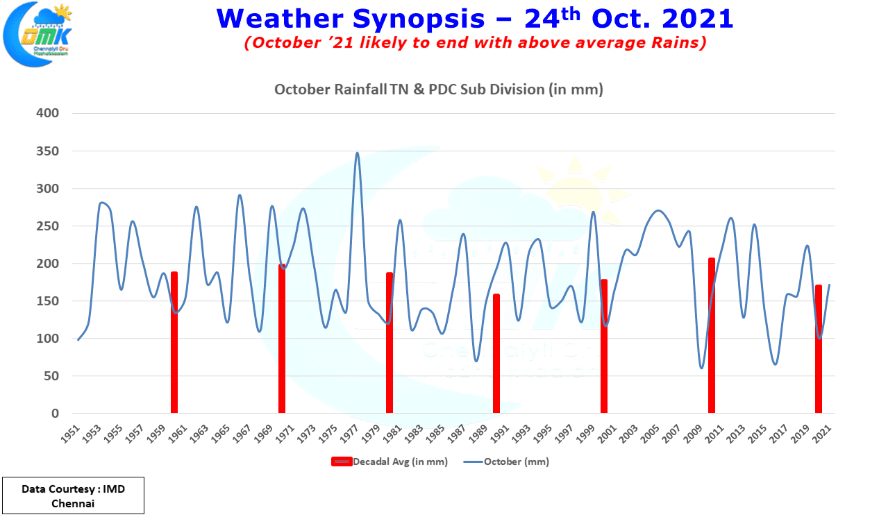
With just a week left for October to come to an end the overall rainfall since the start of Northeast Monsoon season (1st October ’21) now stands as on 23rd October at 171.8 mm with another 7 mm to go for October Long Period Average to be reached. Compared to last year this October is already at about 70% more with still a week to go. Nevertheless one should not forget it is November that is the most crucial month of Northeast Monsoon. Just like how July is considered a critical month for Southwest Monsoon it is November’s performance that decides the overall performance of Northeast Monsoon season.

Looking at the wind charts it is quite obvious we are seeing the Easterlies slowly sneak in to the Bay, though they are still no way strong & streamlined enough. [wpdiscuz-feedback id=”t676q85okl” question=”Which is your best memory of NEM Onset?” opened=”0″]But the stage is set though for things to fall in place for Northeast Monsoon Onset in a few days time.[/wpdiscuz-feedback] In about 3 / 4 days time Easterlies will further extend west reaching the coast of South India & Sri Lanka. After that it could be a matter of time before the rains follow & Northeast Monsoon Onset as well. But all these are at the moment just possibilities & they are not yet certain events.
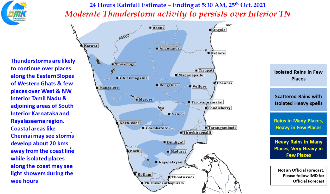
But one thing is reasonably certain is the continuing of thunderstorms in interior parts of Tamil Nadu due to wind instabilities. West Interior TN is the biggest beneficiary of these pre NEM thunderstorms as yesterday also many places in the region recorded moderate rains with few places seeing heavy spell of rains as well. Today similar pattern is likely to continue with places along the Western Ghats, West & NW Interior TN in line to see thunderstorms. Chennai will possibly miss out on the rains in the city areas though western suburbs about 20 kms away from the coast line may see localized development of thunderstorms.
Semma dark clouds in Thanjavur
Got this message 👇
இன்று (24.10.2021) பூண்டி நீர்தேக்கத்திலிருந்து உபரி நீர் வெளியேற்றப்படுவதால், கொசஸ்தலையாற்றின் இருகரையிலும் வசிக்கும் மக்கள் பாதுகாப்பான இடங்களுக்கு செல்லுமாறு எச்சரிக்கப்படுகிறார்கள்.
Again?? Did it rained heavily in catchment areas?
🤔🤔..I don’t know 😬
Back to my native(Pandalkudi),Virudhunagar after a week stay in Thaiyur.
It have rained very good for 45 minutes on 23-Oct(Previous rainy day was 01-Oct) and also rained lightly on 24-Oct(Yesterday)
Luckily the crops at punjai land have survived the dry spell of 22 days and have come well. The rains on saturday have come at the right time and yesterday rains have further helped the fertilizers used by us to dissolve easily
Much needed rains finally in panthalkudi!
Good morning, hazy and calm here, today rains expected from afternoon for N coastal TN.
Snake bands (?) off the chennai coast?
https://meteologix.com/in/satellite/puducherry/satellite-hd-15min/20211025-0130z.html
Have temporarily disabled media uploads because the change in commenting platform has increased the load on server. Need to figure out a way to minimize the load before enabling images back
Ok. I actually only posted a link since you were talking about server load. Is there a feature/plugin for previewing links in comments?
If it is an image link, image conversion is enabled
Massive rains forecasted for interiors as well from Upcoming low pressure particularly for kongu belt and ghats
Is it going to cross near delta as per gfs.
Somewhere around gom-veda most likely!
Or can stall in open waters for long time
Cant say now
Northeast monsoon is getting closer. 25.2 mm from the early morning Thunderstorms
The roads aren’t even wet here…
here too nothing
Pouring rains here
How much is your score from the early morning rains
Ear tearing Thunders😲😲 , early morning typical NEM special has arrived
A historical day by all sorts…
Off-Topic: Pak beat India in WC
On-Topic: GFS beat all other models as ECM also aligns to proper LPA kind of onset system finally
😃
Only one thing went to plan. Liverpool thrashed United
Where is guest 11k?
GFS adamant shows for northern band 🔥
entire coastal drenching
tomorrow early morning
Light rains happened for 10 mins now
New pop up pushing into Cuddalore
Rainfall till now:
Adampur – 34.5mm
Mohali – 24mm
Sangrur – 21.5mm
Fategarh sahib – 34.5mm
Chandigarh – 29mm
Hamirpur Himachal – 34mm
Panchkula – 24mm
Sase chandigarh – 24mm
Paontasahib – 42.5mm
Sundernagar – 16mm
Sujanpur – 21mm
Karnal kvk – 20.5mm
Munsiyari – 20mm
Mailam 125 mm of which 107.5 mm fell in half an hour
Wow..Wow..Wow
Wowowow testing
Hahaha..Input is too short you know 🤣
Second day close miss for us
Thats cloudburst
Intense thunderstorms around north east of sivakasi lashed today
Our area got light rains though saturday rains was super as per my parents words
TN probably may end up at around 220 mm for October, Chennai could probably end up at around 200 mm for both observatories by the time October ends
So are you confident that there will be no system in the SW Bay in the month end ?
Any clarity on how Onset is likely to be
Vera enna valakam pola TV la dhan !!!!
U r master need to say. Not us
Present Models’ trend unable to understand properly actually
Models are not picking because there are multiple signals from Tropics. There is north Bay convection influencing Asia – Pacific mid latitudes wave train.
There is mid latitude rossby waves propagating east in southern hemisphere result of SW PAC Pac convection.
This rossby wave over mid late will converge and initiate a fresh equatorial pulse from s america to IO. NOV 2nd week looks more IO forcing to return
Present pattern ain’t Nina. So only
From tmrw are we back to Disqus? 😜 Or continue with this tool? ☺️
Disqus is history
Oh no.. 😀 …
Disqus was a really great platform, but spammers were ruining the Privacy of the blog, it will take a little time for everyone to adapt.
Are there any special security features for WordPress?
Human tendency is to resist change always including me. The other issue we need to solve is load on the server, with disqus the load was on their server
Yeah, it was a great decision to change Disqus and try to find something better, Word Press is ok but it takes a while to like a comment or edit it
Please do something about that if you can.
Very good rains in madurai for nearly one hour
Madurai has been having a decent thunderstorm season so far
Mostly when i am in madurai it rains in tirunelveli.when in girunelveli it rains in madurai
Here only drizzles so far, humid and calm without winds, Bay getting active, satellite image shows some development over south bay, lets see.
https://mausam.imd.gov.in/Satellite/3Dasiasec_ir1.jpg
6.4 mm in Anna Nagar, places around me got good rains
Gem till 28th oct
Wow! It shows massive rains over Idukki belt.
ecmwf till 28th oct
Storms movement
Today storms seems to be moving in ne to sw direction
Vnr storms turning slowly towards sivakasi or sattur
Anvils in ne/north
In last 2 years I didn’t look at my ne/north for rains
Any updates about oct last week system.what is expected intensity and track.
It’s confirmed Lpa wait heavy rain around in 29th Oct TO NOv 2nd for all coastal side
Track of system.is it near gom or comorin sea
Wait two days it will confirmed
Rain bearing system
GFS latest till 28th oct
ECM forecast ji it’s same or different
decent precipitation for stn to delta and less for ntn.overall bad than gfs
Storm just east of pondy…loud thunders but rain might not happen. Clouds don’t look like rainy ones
tonight improved
Good thunderstorms to the west of Chennai & along the Ghats
it’s pouring like anything aam in my native ☹️ …3 days not even a drop while I stayed there..im crossing Thiruvallur now😭
Haha. Luck of Kumar continues. From tonight Chennai rains will stop
Another round started here.. moderate level now
You got rain In swm , also in nem so lucky place enjoy but here no rain iam waiting for lpa
We were more than 450 mm deficient this SWM. now these pre NEM thunderstorms are saving us
Showers over the ghats and a short one here as well, with sunshine.
Westerly wind burst
This is what GFS GFS good at
Looks like models caving into adamant GFS solution, truly appreciate GFS and its warriors if it happens, only some change that has happened with GFS was delaying initial trough bands by 2 days as other models did as well
அது படமாக இருந்தால் நன்றாக இருக்கும் ஐயா படம் அனுப்புங்கள்
So will models align with GFS on SHAR 2.0 too ? 😜
Started raining with big drops..
wow super pic
raining somewhere around thiruttani…chill breeze and thunder sound here..
63mm here in Tambaram
😲 😲 😲 from todays rain ah😲
Yes from 11.30am today
Idhellam nalla illa….Only drizzles here
Very much isolated stuff today
Chromepet to Guduvanchery seems to be rivalling Cherrapunjee this year
Yes sir when heavy rain started in coastal areas like Mylapore Marina last year I got onset spell 18cm
Here nothing much to count today, continuous drizzles, but the majors should happen in the coming days.
Very light rains happened for 5 mins
Finally saw dark clouds hoverimg over my apartment area with thunders and rumbles…Turning into rains looks doubtful
https://twitter.com/dinamalarweb/status/1452188839821430793?s=20 Mettur touches 100 ft
BAU here, sun playing hide and seek…
Drizzles in our street
Imd can announce onset tomorrow
This is actually more like OHD induced due to mid-level CC near North TN mentioned in IMD post today, actual onset will happen when cloud bands form facing us than sea
Thunder started
On a humoristic note, may be because easterlies are sneaking in, admin has represented it with a snake-like arrow 🤣
Just noticed from the post , The individual years and decadal averages are really a better way to understand a trend and do some analysis on variability in rainfall patterns, the decadal average clearly seems to follow a sine wave kind of pattern averaged over a mean of 170 mm, will be happy to see similar plots for November and December as well for past 70 years
True, sometimes simple stuff gives enough answers for us
Srikanth it’s not COMK.
It is IOMK
I read your article, it was way beyond my comprehension skills. Only thing I can say is we might have had Tropical / Mid Tropical Interactions in the past to which possibly we had not picked earlier
October 27 will be better I think
26-number 8 may be inauspicious
That was close
Heavy rains at ayapakkam
It’s pouring here with winds
Enjoy……….
Can see the software tester circumventing the 12 character limit with full stops 😁😁
Ya tats right.. It was giving error when I typed as “Enjoy”. So had to append the dots to overcome tat error.. 😀
Not an error, just to ensure too many single word messages dont happen
Oh ok sir…….
Couldn’t even see cloudy skies for past 1 week since i returned to thaiyur where as city bloggers often post about rains that too decent numbers.
The rains have been isolated even in Chennai Selva, after a couple of days am getting some rains today
♦ With likely setting in of northeasterly winds in the lower tropospheric levels over Bay of Bengal and extreme south Peninsular India, the Southwest Monsoon is likely to withdraw from entire country during next 48 hours. Simultaneously, the Northeast Monsoon rains are also likely to commence over Southeast Peninsular India during next 48 hours. – Courtesy IMD Mid-Day Report
All set for சென்னையில் ஒரு மழைக்காலம்
welcome words for me as I have started to chennai🤩🔥
Chrompet AWS so far 25mm n counting….
Max gusts recorded 50kmph !!!!!
Lucky thirudans
Neenga thaana andha “big big drops falling from the sky” 😀
Light rains at Anna nagar, 4 mm so far
Heavy rains in TBM
Very heavy rain with winds, lightning and thunder
which place?
Massive thunder, looks like the first roar of Lion NEM signalling “naan vandhutten nu sollu”
lot of dragon flies flying here in my native 😲😲
Here too. (adding these extra words since I am told that my comment is too short).
Ha ha.. I added dots to fill the gap.. 😀
Plesant winds here, still no rains, thunders nearby.
Major rains to your North I think
During SWM, we are cheated by western, northwest and southwest suburbs , during NEM , we are cheated by extreme coasts , more so, life of Mambalam and Anna nagar will go in between cheaters 😝😜🤣
Yes always we miss out by getting stuck between the devils and the deep sea
Heavy downpour in Adam
Two awesome heavy spells of rains from 11.45 till now in kilpauk
To which place you are passing it , I got some mild showers only , cheating Sailu
Rains started
No model is showing any rains for us…even if it shows its not raining after Oct 1st.
Varuna bhagavan is here to quench your thirst
I am talking about my native…Kelambakkam have got good rains around 21cm this October so thaiyur should have got atleast 15cm
Tue should be good..hope bands reach from rmd towards your place
Veda-tuty coast expected to be active very much on tuesday..
Very dark towards North
Today rain which model is win
GFS !! I guess
Drizzling started here
Super cool winds blowing in from NNE direction , there is also some petrichor and smell of ocean along with it
ஆமாம் அய்யா ஜில்லுனு உள்ளது
heavy sweating here… pouring.. pounding from my body…lot of dragon flies flying…it’s gonna rain heavy it seems in my native
Rain my area Royapettah I think nem is onset by today itself moderate rain
Iam so happy nem is onset today itself
Surface level Northeasterlies setting in from today afternoon /evening , atleast there is some model consensus for that , waiting to see the transition on my weather station and welcome first signs of NEM 😍,perfect Sankatahara Chathurthi day to step in and remove our obstacles for rains 🙏
Good morning to all ❤️.
Have a nice day 😊.
@Srikanth didnt read my post 🙁
Which post are you referring
Cricketwriters link below
I read and commented with reflecting mirror image (this is Chirality in chemistry like our both palms) in +ve/-ve anomalies.
FOr example if we see both 2005 & 1997 0.2101 Velocity anomalies, it looks both are reflecting mirror images in terms of ascending (-ve anomalies) and descending (+ve anomalies) cells.
SO as per the atmospheric circulation patten view, I would consider both 1997 & 2005 dynamics are same at least till West Pacific & Indian Ocean despite having minor changes at Atlantic ocean side.
Thus both 1997 (Super Elnino) & 2005 (cool ENSO) seen normal SWM and super NEM.
However if we see one more Super Elnino 1982 (0.2101 Velocity potential anomalies), that resulted in both worst SWM & NEM rains.
Here I found the major difference between 1997 & 1982’s is in ascending cell at East-pacific. 1982’s ascending cell is far west and close to date-line and more distorted/unsymmetrical spread into Southern Hemisphere.
However both 2005’s descending cell & 1997’s ascending cell had very symmetrical on the equator and far east orientation at east-pacific.
Note:
All three 2005, 1982, 1997 had very nice major two-cell component spread in walker cell pattern along the tropics.
Oh I could able to upload only 2005 image
Here
1997
Here 1982 image
Will see and come in evening for post 2007-12 too.
Hi Rao ,nice presentation ,you did your PhD in Chemistry? ,nice to see analogies from chiral point of view , loved to read as a kid in all sugar-base compounds (I always used to think the similarity between Tamizh Sarkkarai and scientific name Saccharide, may be the term went from here)
Okay Rao , 1982 seems to be more of a Modoki flavour in Atmospheric pattern, whichever Modoki on either side of ENSO coin more so has resulted in drought as per available data
Will be happy to know your native at Andhra 😊
Thank you though don’t with whom I am chatting.
Anyhow I am enjoying your nice presentation in the weather dynamics, which matters most :))
MY Native is Vijayawada, Central AP.
Yes….1982 is having more-modoki (non-classical/non-canonical) type atmospheric circulation unlike both 2005 & 1997’s East-pacific (classical/canonical) atmospheric circulations.
Oh..nice to know your full details. Actually I reside at Hyderabad. Let’s have a meet if there is a chance in coming days.
Why chiral
Also like twin boundaries is Physics😀😁😂
Yes… exactly twin boundaries too :))
Everything going above my head, the only twins I know is Yin & Yang..
Yin & Yang means Twinflames/Twin Souls 😉😅
Let me check and come back
Small issue on delete screen..
Go to page 3 on delete screen for example. Delete any comment. GO Back to page 1. It shows no comments and shows the value 0.
However when we reopen the window the comments are retained
Looks like you have been in software testing team in some IT sector , developer ah undu illa nu senjurvenga polruku ,paavam😂
Ha ha.. ya 😀
Testing naaley kutham kandupudikiradhu thaana.. 😀
Nadathunga nadathunga , innum nariya kandupidichi wordpress ke direct ah mail pannunga 👍👍
Mmm.. pannalam.. 😀
Naangale paavam irukkara timela etho panrom…
Testing……
Varuna bhagavan Testing?
Edhaachum paathu seinga amaichare , nalla mazhai vendum
You are enjoying the rains & still want to test
Light rains now
OMG…rains ah…idho varan ippayae …started from my native
Neenga inga vandha anga mazhai aarambichurum Kumaaru
aama…my east getting heavy dark…seems it’s gonna rain in 30mins..I’m in bus now to tiruttani from my native…it’s all fate☹️😭
Overhead looks good for some spells
Hi.. there is no option to delete the comments which we added?
You will find all your comments here, use this space to delete comments you want to delete
Ok thank you bro..
You can try deleting a comment to check how it works
It’s working now
Ya I’m able to delete now.. thanks
Yes no option to delete
we can delete …option is there
Rao jo,
Basically when southern eastern IO near AUS is cool compared to Madagascar means, the climatological position of mascarene high will be eastward and close to Australia and not typical position where it favors Indian monsoon.
This cold south eastern IO in normal case coincides with warm ENSO decadal signal.
How this happens is Pacific warm pool when it is displaced eastward than normal and extended to Hawaio and SPCZ, the convection there shifts the High pressure to SE IO and cools the SE IO.
This cooler south IO will weaken pressure gradient between Tahiti and Darwin. This will mean frequent MJO circuit around western hemisphere.
My thinking is if we analyse the Pacific warm pool longtitudnal location and its symmetrical and non symmetrical orientation, we will be able to derive more answers and assist long range forecasting in Tropics
Agreed. Then let us know how this both IOD & SIOD coordinates each other
Also is it must the MH’s position to stay near Madagascar coast or MH’s strength irrespective its position that decides the fate of SWM?
1997 and 2005 had negative subtropical dipole. Warm SE IO
So only SSTA that governs the dynamics or the atmospheric circulations that governs the dynamics. Or both? If so in what way?
How SSTA aligns Tropics
woow…it’s 2005 in comment…U r guest11k…am I right??😁
Wrong am not
ok let me get him soon with other name when he comment with 2005
Oh..no Guest11k is missing? Looks original name getting displayed here in this new comments section 😀
If original name getting displayed then Guest11k never ever comment it seems ;))
Yeah :((( let guest log in via guest11k name in wordpress
Yes… that’s only option for Guest11k :))
Srikanth sir.. pls tell me how to check who liked our comments..
That is tough I think Jagan.
Ok.. no problem
Kelvin wave
So many waves, getting confused what to follow
Thanks for editing Sir
corona wave🤣
Rains can happen soon
In our street it think
gfs vp
Konni 105mm
Thodupuzha 87.2
Punalur 75.2
Neyyattinkara 68.5
Kanjirappally 47
Varkala 38.2
Vythiri 26
Peermade 25.3
Aryankavu 25.1
Kuppady 24.7
Idukki 22.8
Mannarkad 21
Perumthenaruvi 138.6mm
Nilakkal 92
Konni Estate 80.5
Pathanamthitta 65.8
Vadasserikkara 58
Moozhiyar 53.2
Pathanamthitta dts seem to have borne the brunt
37 mm here
gfs
cfs
Wait for convection from Indonesia/SPCZ to weaken. Then models will pick signals correctly
yes
Bangalore city IMD – 364mm so far this month
Rainfall till morning: bangalore city rocking this October
Bangalore city IMD – 41mm
Srinagar – 34.4mm
Mayabandar – 22mm
Hut bay – 18mm
WD impacting Himachal pradesh
https://cricketwriters.wordpress.com/2021/10/23/changing-indian-ocean-influencing-indian-monsoon/
@Srikanth read^
Good one, which you used to tell us for last 3-4 yrs. I went through this completely. Here I had couple of points.
(1) +SIOD means SW/W Indian Ocean having +ve SSTA. This means strong trades flowing towards Somalia coast thus towards Indian subcontinent?
(2) Also I generally consider +ve & -ve anomaly equally. But only see whether overall trend missing any symmetry.
To understand this point, we would take tropically SWM & NEM good years like 2005 & 1997 for June-September. For these two years just plot .2101 velocity potential anomalies.
After plotting just see EIO-MTC region. In 1997 we had super strong +ve anomaly, which is quite contrary to 2005’s strong -ve anomaly.
But how both 2005 (Neutral to cool ENSO) & 1997 (Super Elnino) years given normal SWM & bumper NEM.
This means before thinking about decadanal/multidecadanal shift, our style of understanding +ve anomaly and -ve anomaly need to be changed/corrected?
If need to change/correct then in what way it must be? As per my understanding, we need to see the overall symmetry in the anomalies.
For example, you plotted last 0.2101 streamfunction anomalies for last 3-4 year & few Lanina years. Those 2 plots, please try to super-impose each other instead of just judging based on seeing any deviation in the terms of +ve/-ve anomalies.
So overall please try to super-impose both plots irrespective of +ve/-ve anomalies. If both plots of super-imposing mirror images (in chemisy this phenomenon is called Chirality like our both palms), then need to understand there is no big problem in the weather dynamics in terms of yearwise/decadanal/multidecadanal shifts.
Loved the other important contents/posts of this site so much, thanks for sharing!
Rainfall in Punjab. Under the influence of Western disturbance:
Gurudaspur aws – 39mm
Nur mahal kvk – 34mm
Ludhiana – 23mm
Ferozpur kvk – 35.5mm
Ferozpur – 31mm
Fategarh sahib – 14mm
Moga – 12mm
Ropar kvk – 28mm
Sangrur – 12.5mm
Budhsingh wala kvk – 13mm
Image didnt upload
As long as this upper level WAF acting from Indo-Pacific region, it will not allow MJO to enter Indian Ocean.
When Tropics influence from western hemisphere we need IO to shut down. However , we still have this north Bay altering mid latitude pattern and you see a coherent burst of convection source in SPCZ.
Once these relax and Indo is shut down, we will see pressures reduce over Asia.
Until then any systems forming inbetween will influence southern hemisphere of IO than N IO
ECMWF EPS is doing the large scale pattern correct here. So watch the trend. GFS seems overcooking the WWB.
Already yesterday I found and commented…
BOB is with ER Convection, that need to weaken further prior MJO/CCKW Convection to bloom @ NEM onset.
See SPCZ zone too
Ok…but why SOI not falling down in response to SPCZ??
Fairly widespread rain in desert region of West Rajasthan:
Sriganganagar – 35mm
Hanumangarh – 25mm
Hanumangarh kvk – 12mm