
It may surprise naming of tropical cyclone has been existing for many years though the practice of naming cyclones in the North Indian ocean basin started a couple of decades back. While the practice of naming cyclones during the first half of the last century did not follow a pattern since 1953 tropical cyclones (hurricanes) in the Atlantic started having names from lists created by the National Hurricane Centre. The common thought behind naming cyclones was it is easier to remember names especially when there are multiple cyclones in the same basin as is the case many times in the Atlantic & Pacific basins. A very good read on Tropical Cyclones has been published by WMO and is available here. Incidentally Hurricanes and Typhoons are also Tropical Cyclones by nature. “A rose by any other name would smell as sweet” – William Shakespeare.
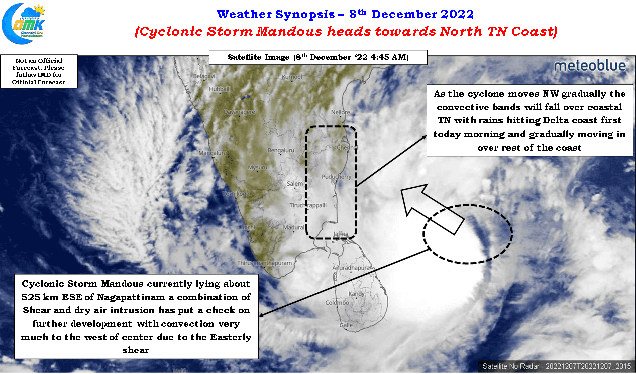
In the northern Indian Ocean basin RSMC New Delhi Tropical Cyclone Center is the nodal authority to name cyclones and it follows in the alphabetical order of 13 countries that are part of the panel starting from Yemen to Thailand. Mandous (pronounced as Man Dous) is a name provided by the United Arab Emirates and translates to treasure box in Arabic. Mocha the name given by Yemen is the last name in the first list of names before we head to Biparjoy given by Bangladesh to start a fresh cycle of names. Cyclonic storm Mandous is now roughly 525 kms ESE of Nagapattinam and about 625 kms to the SE of Chennai has started moving in a NW direction after moving most of yesterday in a WNW direction.
Satellite image indicates Mandous has been fighting against unfavorable conditions in the form of moderate to high wind shear from the East and also dry air intrusion to some effect. This in a way has put a break on intensification as most models expected to happen from today. The convergence and divergence chart also indicates Cyclonic Storm Mandous is almost close to reaching its peak intensity and unless a drastic change in conditions it is unlikely to intensify into a severe cyclonic storm. There was tight alignment among models about Mandous reaching peak intensity today. With weather models indicating no reduction in wind shear and dry air to continue to remain around the periphery of the cyclone it appears the next 6 to 12 hours may be the peak period for Cyclonic storm Mandous.
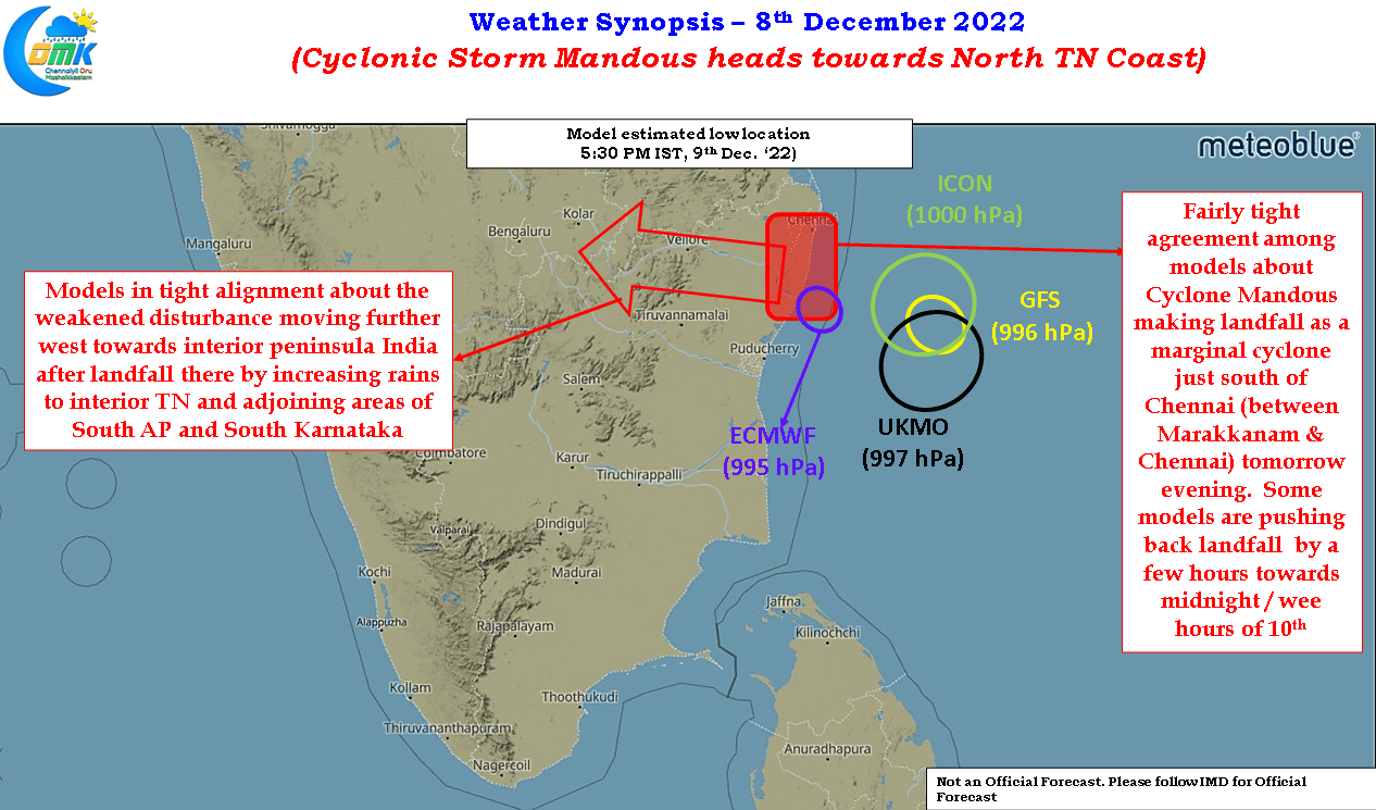
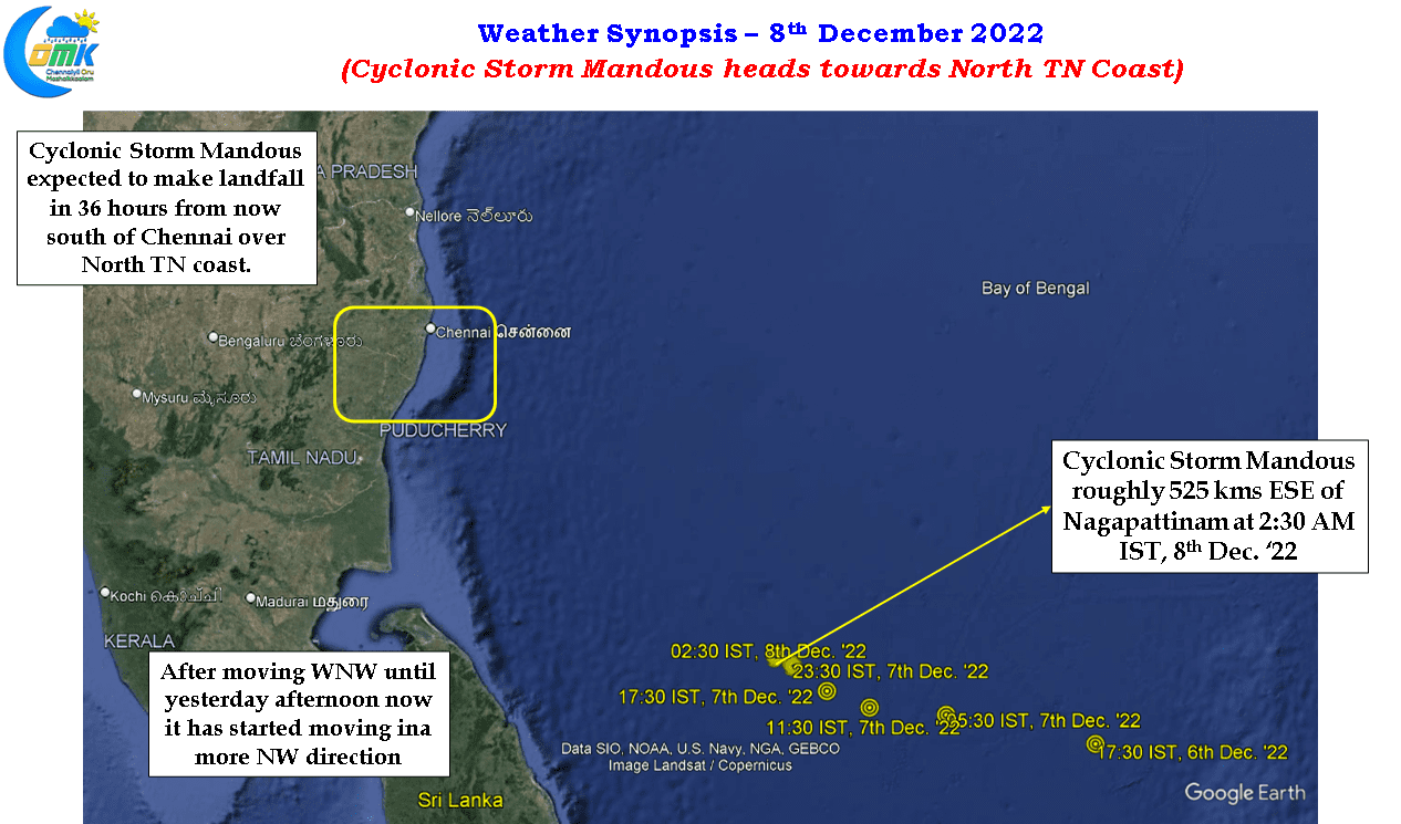
There is a fairly tight alignment among models about Mandous remaining as a cyclone for the next 36 hours or so when it gets close to landfall over North TN coast. Mandous may end up as a text book example of how numerical weather models could be an important tool in weather forecasting with very tight alignment about the landfall zone also. There is a high probability the landfall zone could be south of Chennai along the North TN coast between Marakkanam and Chennai as possibly a deep depression or a marginal cyclone. With shear still playing a role and potentially Mandous making landfall as a sheared cyclone there is a very high possibility this would give widespread rains not just along the coast but also interior parts of Peninsular India as the remnant moves further west. There is some divergence among weather models about the timelines with ECMWF picking a landfall by tomorrow evening while others pushing back the landfall to the midnight / wee hours of 10th December. Nevertheless landfall is expected to happen between 36 to 48 hours from now.
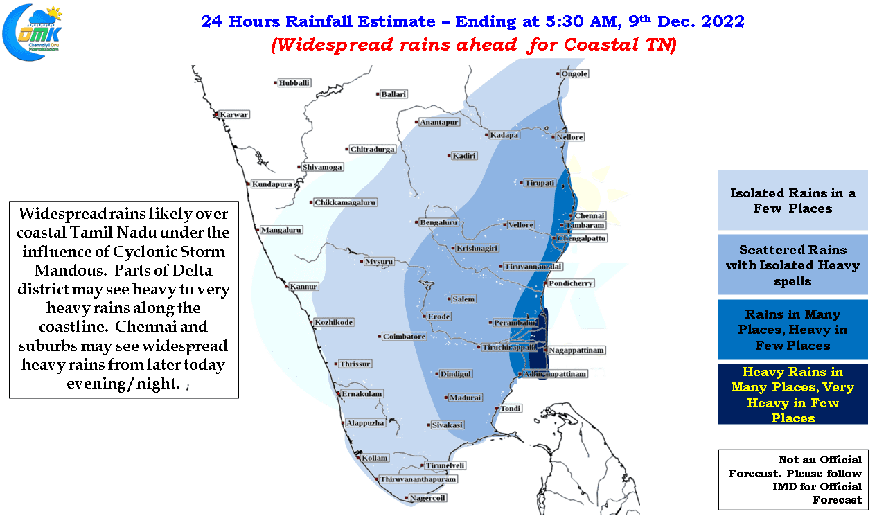
Giving a precipitation estimate during a cyclone is always tricky with sudden change in wind shear altering rainfall pattern drastically especially when the CDO gets sheared and convection gets set aside to one side. We have had instances where cyclones like Nilam giving more rains in Tirupathi than Chennai which was just 50 kms north of the landfall place near Mahabalipuram. The overall theme though is rains are expected to start in coastal areas of delta districts first in a couple of hours from now gradually pushing to the rest of the coast as we progress further in the day. Between today evening and tomorrow morning we may see widespread heavy rains along the coast of Tamil Nadu with isolated places between Pondicherry and Vedaranyam getting very heavy rains. Chennai and suburbs are likely to see widespread heavy rains later tonight.
As far as rainfall estimate goes it is to give an idea on what to expect and in real time conditions the actual rains may drastically differ due to fast changing dynamics on account of Cyclonic Storm Mandous.