

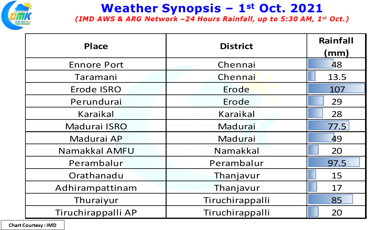
நான் வந்துட்டேன் சொல்லு, திரும்பி வந்துட்டேன்னு சொல்லு goes the famous dialogue from the movie Kabali. Similarly Thunderstorms announced their return back over Tamil Nadu yesterday as they dumped heavy rains over many parts of Tamil Nadu. In particular Madurai, Erode, Perambalur & Thanjavur districts saw heavy rains at many places. The Erode ISRO AWS of IMD recorded nearly 11 cms bulk of which happened in the wee hours of morning while Madurai and surrounding came under night long thunderstorm activity. Perambalur IMD AWS recorded 9 cms of rains while the neighboring Thuraiyur in Tiruchirappalli district recorded more than 8 cms.
Interestingly Chennai & surrounding areas kickstarted the thunderstorm activity yesterday through the spell of rains in the morning hours that brought good rains to the Northeast suburbs of the city. Ennore Port IMD AWS recorded more than 4 cms of rains between 8:30 & 10:30 in the morning while the city areas recorded light rains at most places. All in all it was indeed a bright start to what is likely to be possibly the best phase of rains for the interior areas Tamil Nadu, particularly the West & NW interior areas which typically do not benefit much from either of the monsoons & mostly owe their rains to thunderstorms that get triggered due to atmospheric & wind instabilities.
In the meanwhile the remnant of Cyclone Gulab is on its way to set another unique record by becoming the first pulse in possibly fifty years to intensify into a Cyclone over both Bay of Bengal & the Arabian Sea. The remnant is already a Deep Depression showing an extremely good structure, even better than during its life cycle in Bay, and is likely to intensify into Cyclone Shaheen a name given by Qatar in the North Indian Cyclone Name Roster. The Well Marked Low over East India is showing signs of disintegrating as it possibly shows effect of pseudo stationary movement over Land. Gradually it will fade away as North India starts coming under dry Continental winds from Northwest influenced by the west moving Cyclone.
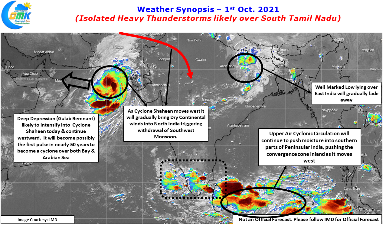
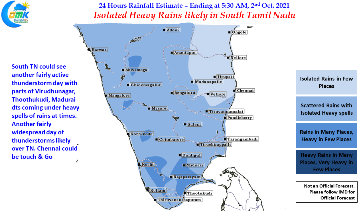
Today once again promises to be another widespread day of thunderstorms over Tamil Nadu under the influence of the Circulation over Southwest Bay adjoining Sri Lanka. Weather models indicate South TN could come under heavy spell of rains in a few places as the circulation slowly moves west coming closer to the TN coast. Places in Madurai, Virudhunagar & Thoothukudi dt could come under intense thunderstorm activity later in the night while most parts of the state will receive light to moderate showers.
With convergence likely to shift to interiors North Coastal TN could be a day of touch & go with Chennai possibly needing some luck to catch up a good spell of rains. But the next few days promises to be good for Chennai too with the first week of October likely to bring in 7 to 10 cms of rains for the IMD observatories in the city.