
எப்பொருள் யார்யார்வாய்க் கேட்பினும் அப்பொருள்
மெய்ப்பொருள் காண்ப தறிவு. திருக்குறள் 423 (அறிவுடைமை அதிகாரம்).
எப்பொருளை யார் யார் இடம் கேட்டாலும் (கேட்டவாறே கொள்ளாமல்) அப் பொருளின் மெய்யானப் பொருளைக் காண்பதே அறிவாகும். — மு. வரதராசன்.
To discern the truth in every thing, by whomsoever spoken, is wisdom.
Not for the first time we start a post with the above couplet from Thirukkural. It has been shared many a times in this blog & almost every time when we are at the cusp of the seasonal change between Southwest Monsoon & Northeast Monsoon and it is apt to once again remind everyone of the wonderful advice Sage Thiruvalluvar has offered to us.
Yesterday turned out to be a curtain raiser for the upcoming Northeast Monsoon season in a manner which could have been called the Onset of Northeast Monsoon if not for Southwest Monsoon not yet withdrawing yet from the Indian Sub Continent. Very little activity the previous day night, convection picking up off the coast just after midnight and a sudden spell of rains coming in from the Northeast during the early morning hours along the coast. Spells of rains right through the day of varying intensity & finally convection moving inland as well under the influence of Easterlies.
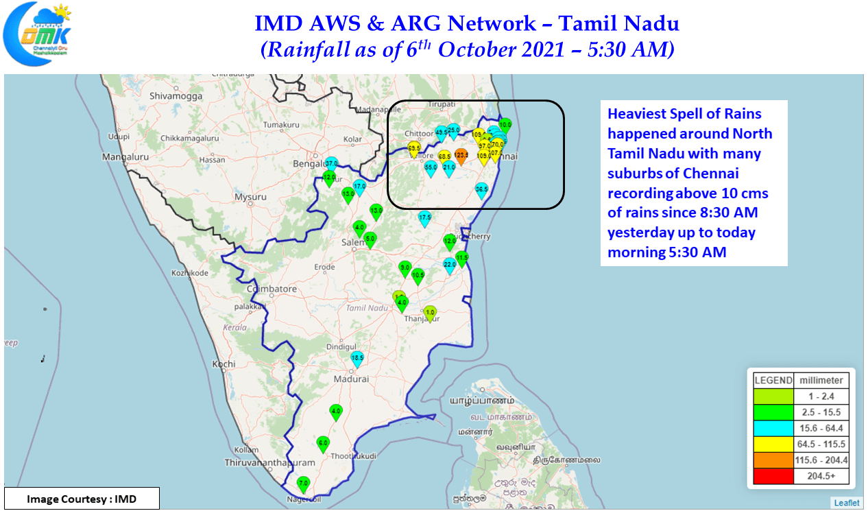
Chennai & suburbs received very good rains from the wee hours that continued till almost late in the night. The IMD AWS at KVK Kattupakkam, about 40 kms to the SW of Chennai recorded nearly 11 cms of rains while Tirur KVK to the west of Chennai in Tiruvallur district also recorded same amout of rains indicating the fairly widespread rains around North TN. The Upper Air Cyclonic Circulation that was seen off the coast of Tamil Nadu was the primary driver for the rains recirculating moisture over coastal areas of TN & South AP regularly right through the day.
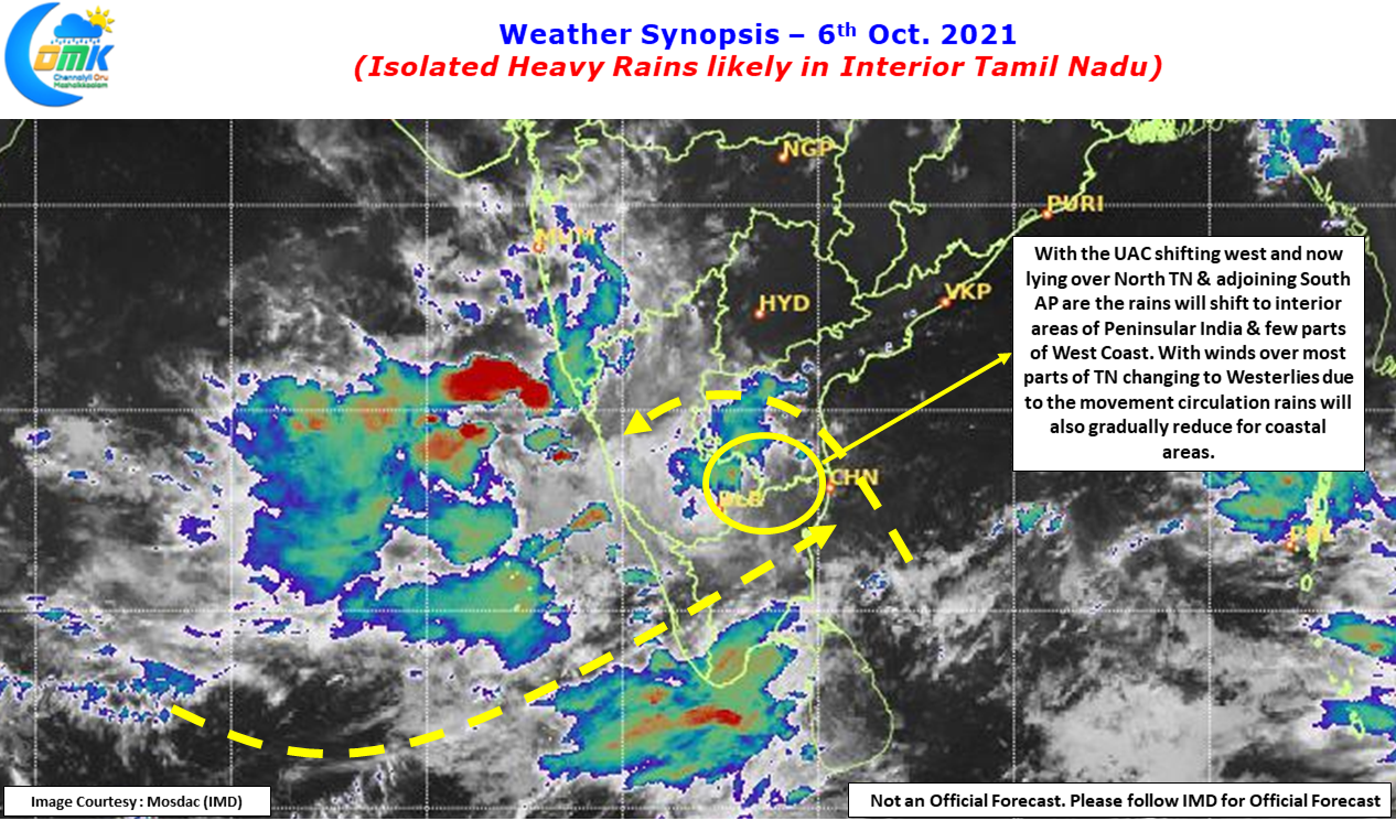

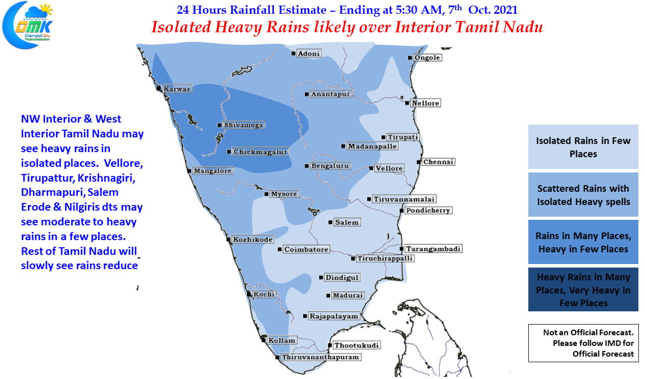
With the circulation now shifting west and now seen lying inland over North Interior TN & adjoining parts of South AP the rain bands also are likely to shift west as moisture will now be pushed inland by the circulation. This is likely to bring heavy rains in a few places over NW & West Interior TN particularly the districts that adjoin South Interior Karnataka. While coastal areas may see reduction in rains from today, Vellore, Tirupattur, Krishnagiri, Dharmapuri, Salem, Erode & Nilgiris may see moderate rains at many places with isolated heavy rains in a few places.
Now Coming back to the Thirukkural Couplet at the start of the post. The first week of every month brings forth the long term model outlooks from various climatic models providing an indication of what lies ahead for the next few months. Over time they have become a good tool to develop a broad based understanding of how seasons could turn out. While it indeed gives a broad based understanding the experience with MJO for the past couple of months show this year especially from June onwards long term models are indeed struggling to capture the transit & Influence of MJO effectively. If one were to look at MJO over the last couple of months it has indeed struggled to get itself going beyond the MTC due to standing wave like condition prevailing over the region. This could turn out to be a double edged sword as SWM 2021 proved with August completely getting washed out due to unfavorable MJO influence for pretty much the entire month. So lets not forget “much there is between cup and the tip of the lip.”.