
Why did cyclones like Gaja / Vardah intensify much more than what models initially estimated? Why did Arabian Sea throw abnormally high number of cyclones last year? Are these related to Climate Change / Global Warming?
As Weather enthusiasts we constantly need to ask questions in our quest to learning. The weather bloggers of Chennai over the past few years have been discussing a lot about how cyclones like Gaja / Vardah could intensify so close to the coast defying earlier learning about cyclones losing intensify closer to coast. We have attempted to answer these questions through the following process
- Create a List of the Most Intense Cyclones over the North Indian Ocean to understand pattern if any over time
- Create Decadal Cyclone Tabulation to understand any change in long term pattern if any.
In an attempt to identify answers for some of the questions and also try to understand Long Term Change if any in Cyclones over North Indian Ocean we have tried to piece together this post using the Best Track Data from IMD since 1990. In order to stick with consistent data we have restricted ourselves to the best track data of IMD since 1990. While IMD cyclone data exists since late 19th century there are debates on the intensify & wind speeds in many a cyclones.

Looking at the Top 10 Most intense Tropical Cyclones since 1990 over North Indian Ocean the list its pretty straight forward with the Noughties decade edging the two decades of the millenium. The Odisha Super Cyclone of 1999 remains the strongest cyclonic storm over North Indian Ocean with Kyarr now becoming the second strongest cyclone edging past the 1990 AP Super Cyclone & 1991 Bangladesh Super Cyclone. To give a perspective of the pre 1990 era cyclones we have listed the 3 most intense cyclones which had similar numbers.
Now lets dig a little deeper.

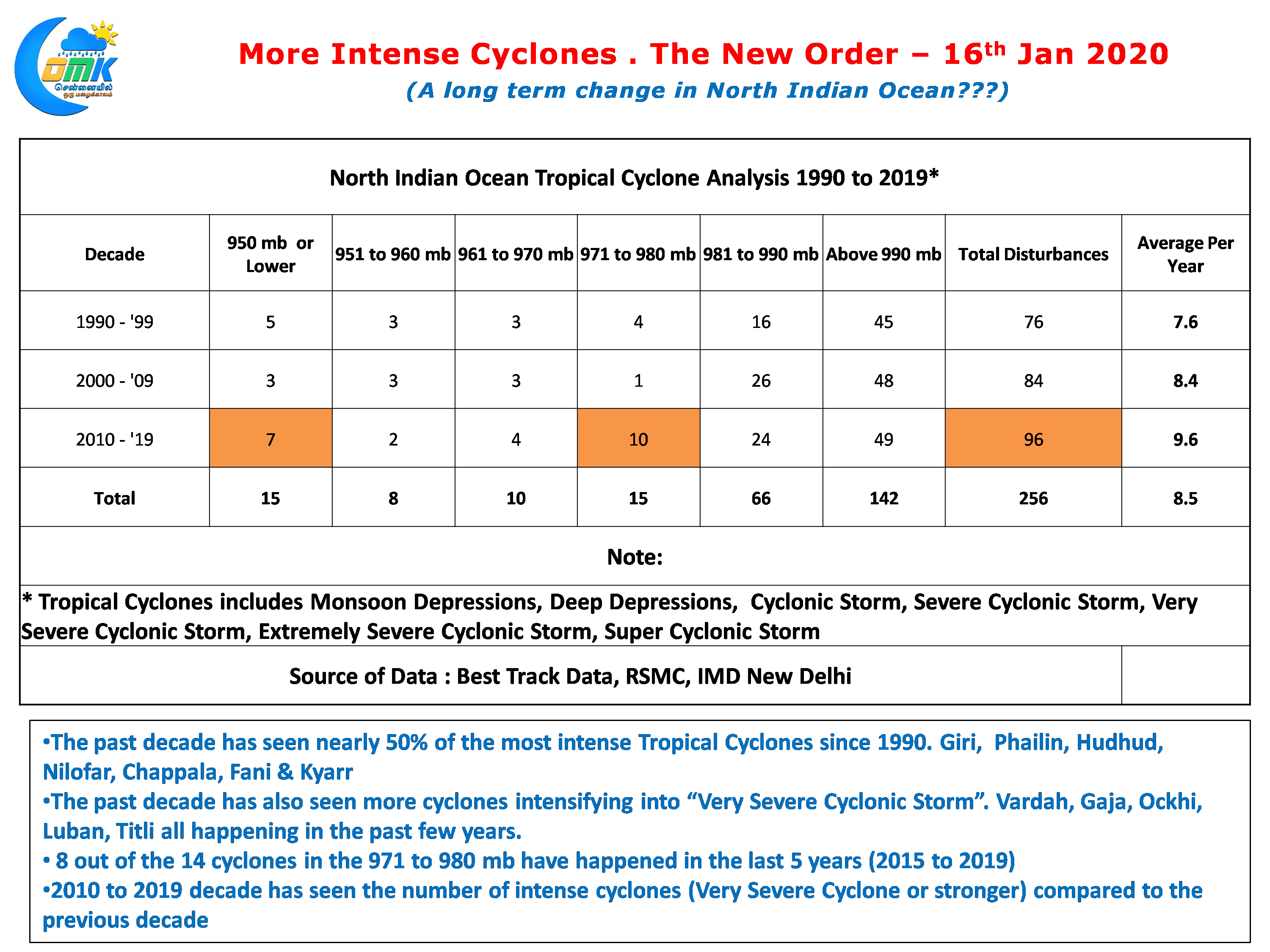
The decadal compilation of Cyclones shows a definitive pattern which needs to be investigated. Looking at the numbers it appears so the past decade (2010 – ’19) has possibly seen many a cyclones jump one category above in terms of intensity. 7 of the 15 most intense cyclones since 1990 have happened in the past decade with the first five contributing Giri, Phailin, Hudhud & Nilofar while we saw Chappala in 2015, 2019 saw Fani in Bay of Bengal & Kyarr in Arabian Sea. 2019 becoming the only year to feature two Sub 950 mb tropical cyclones in a single calendar year.
Another very critical point the data seems to show is the increase in the number of Very Severe Cyclones with the past decade seeing nearly 2/3rd cyclones in the 971 to 980 mb category of the total cyclones in the past 30 years or so. Gaja, Luban, Vardah, Ockhi & Titli are part of this group of cyclones which also showed the characteristics of intensifying very close to the coast.

One of the key components in the development of a tropical cyclone is ocean temperatures. Warmer oceans in conjunction with favorable wind shear has thrown up intense cyclones over many instances. The Sea surface temperature anomaly map over the Indian Ocean is clearly showing a warming trend with lesser number of cooler episodes seen over the past couple of decades or so. But still this does not answer the question about intensifying cyclones near the coast.
Tweaking the timelines & parameters little bit we tried to understand if there is any change in absolute sea surface temperatures rather than anomalies to find an answer for the question. Using the very resourceful tool from NOAA ESRL PSD we created sea surface temperature maps averaging it over 5 year periods from 1980. As the video above would show there is clearly a pattern emerging.
North Indian Ocean is slowly but steadily seeing an increase in Ocean Temperatures. The past decade is almost resembling a basin wide warming scenario. Critically over the past few years we can see the average sea surface temperatures along the East & West Coast of India is now nearly 29°C which possibly explains why many cyclones are intensifying closer to the coast. This is likely to become a very critical issue in terms of disaster management for the coastal states as any long term change would mean more intense cyclones are likely to landfall along the coast
To Summarize there is a fairly clear pattern emerging about North Indian Ocean throwing more intense cyclones compared to earlier. There is a clear indication of increasing ocean temperatures over both Bay of Bengal & Arabian Sea.
Its now time for professional researchers to understand if this is a long term change & is global warming playing a role