
A lot of time people interchange the terms “Weather” and “Climate” while discussing daily weather events. We often hear people mentioning “Climate in Chennai is pleasant today” when it should have been “Weather in Chennai is pleasant today”. Weather relates to day to day phenomenon while through Climate we refer to long term trends. In other words if one were to average the daily weather readings of a place over long period that becomes the Climate trend for the place
In this context it becomes essential to revisit even Climatic trends time to time. For example through this post in February we had discussed about how the long term rainfall trends for the IMD observatory at Chennai Airport has been changing. Similarly the official weather body of India, IMD, time to time revises various weather parameters for a station like Mean Temperatures, Average Rainfall etc. But for the first time since Normal Onset & Withdrawal Dates for Southwest Monsoon were created IMD has now revisited them in an effort to realigning the dates to more current context.

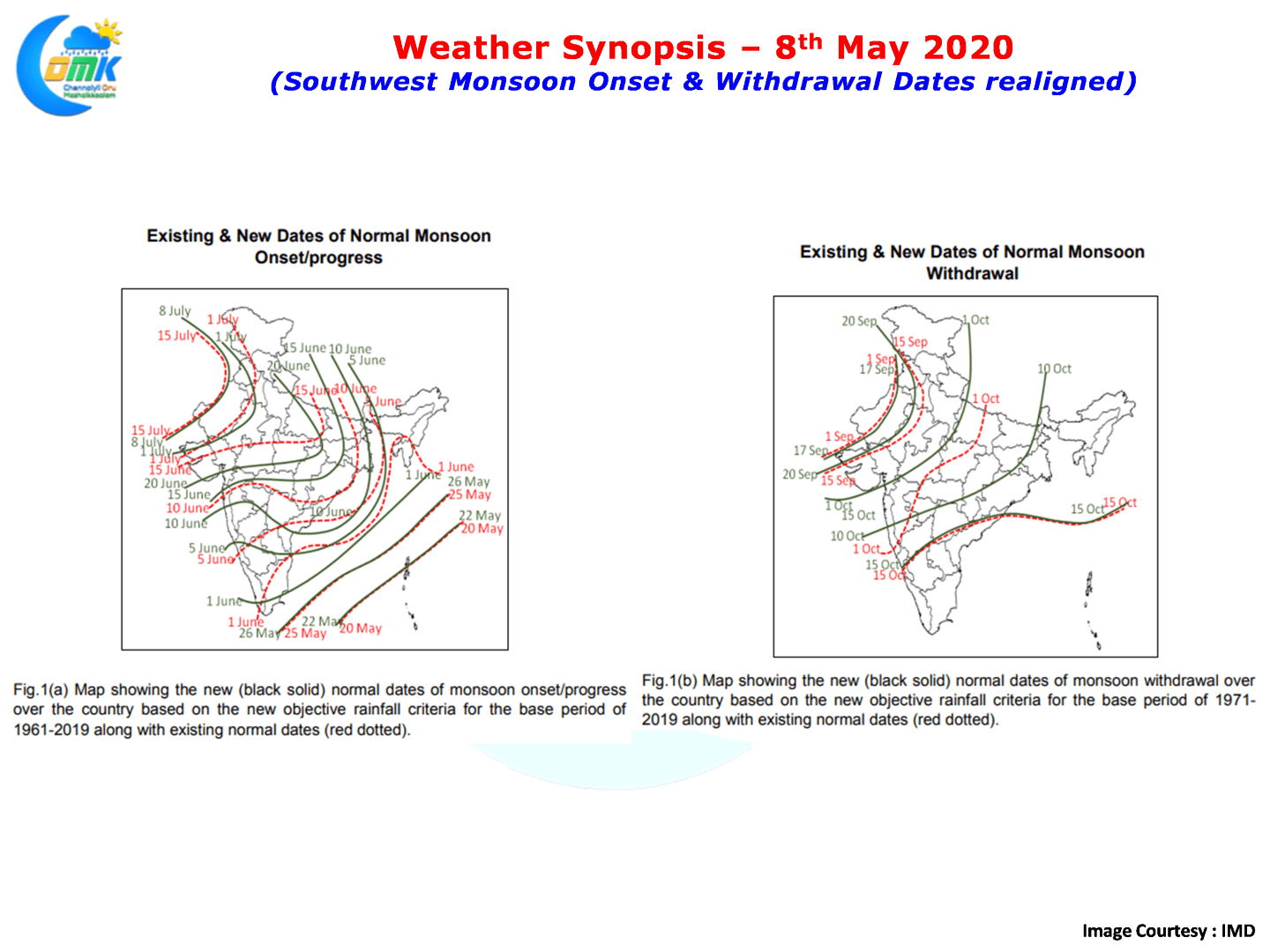
The present normal monsoon onset and withdrawal dates are based on
records of only a few stations (149 stations) during the period 1901-1940. India Meteorological Department (IMD) has now revised the normal onset and withdrawal dates based on recent data. The normal dates of onset are revised based on data during 1961-2019 and normal dates of withdrawal are revised based on data during 1971-2019. IMD has designed new objective criteria for defining monsoon onset over the entire country based on daily gridded rainfall data set.
The new objective criteria used for deciding monsoon onset/progress dates are designed so as to closely simulate IMD’s operational onset dates. However, the new withdrawal dates are fixed using the IMD’s operational withdrawal dates during 1971-2019. Monsoon onset over Kerala remains the same, i.e., 1 June. However, new monsoon advance dates over the states like Maharashtra, Gujarat, Madhya Pradesh, Chattisgarh, Telangana, Andhra Pradesh, Odisha, Jharkhand, Bihar and parts of Uttar Pradesh are delayed by 3-7 days compared to existing normal dates. However, over extreme northwest India, the monsoon arrives now little earlier, on 8th July compared to the existing date of 15th July.
There are however appreciable changes in the monsoon withdrawal dates, especially over Northwest and Central India. Monsoon withdraws from NW India almost 7-14 days later from the existing dates. There is no change in the final withdrawal date over south India, i.e., 15th October. These new dates are relevant for many applications like agriculture, water and power management etc.

Now back to Weather from Climate. In a news that could bring some cheer to not only weather watchers but also common people of Tamil Nadu a developing East West Shear Zone could bring conducive conditions for the development of thunderstorms & associated rainfall over Peninsular India. While on the Eastern side the remnant circulation from the now defunct “அழையா விருந்தாளி” LPA is persisting while models indicate a developing weak circulation off Sri Lanka. Possibly under the influence of ER wave in the region this Shear Zone is expected to develop.
This could augur well for the development of thunderstorms over interior Tamil Nadu in the coming days with next week promising to provide some rainfall activity over the states of Tamil Nadu, Kerala & Karnataka. It appears the coastal areas are also likely to benefit from this Shear Zone next week though we need to be patient on what could be the quantum like.