
Has Northeast monsoon made onset?
This is the billion dollar question now not only among weather enthusiasts but also common public for the past few days. The early morning rains around coastal places like Chennai for the past couple of days along with fairly widespread rains influenced by thunderstorms during the evening / night hours over the interior areas has brought forward this very valid question which provides an opportunity to give an update not only on the prevailing atmospheric dynamics over the Indian sub continent but also explain the back ground behind the last phase of Southwest monsoon withdrawal and Northeast monsoon onset. Is rains from the East / Northeast alone enough to announce onset of Northeast monsoon?
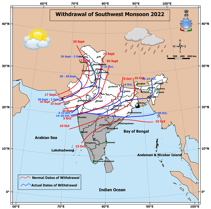
IMD announced further withdrawal of Southwest monsoon yesterday with effectively large parts of the country bidding adiue to the Indian summer monsoon. Crucially parts of Maharashtra, Odisha, Chhattisgarh, Telangana and North Interior Karnataka is still under Southwest monsoon. While the onset criteria of Northeast monsoon is not as robust as Southwest monsoon there is one important factors that IMD indeed considers before announcing the onset even if there is widespread rains over Tamil Nadu and the prevailing wind pattern is Easterlies.
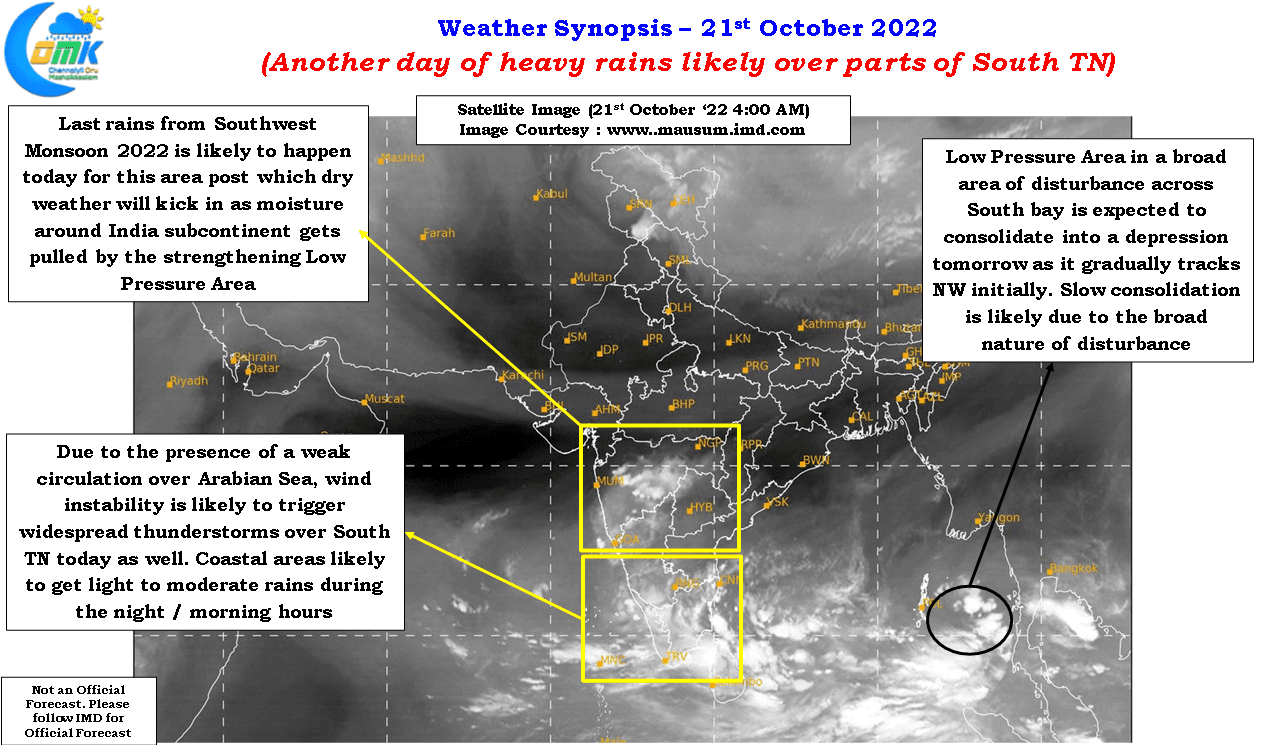
Southwest monsoon needs to withdraw upto 15N latitude. Roughly places to the North of Karwar to Kavali latitude needs to have seen withdrawal of Southwest monsoon before IMD could announce the onset of Northeast monsoon. Currently if one were to look at the satellite image parts of Maharashtra and North interior Karnataka along with parts of Telangana continues to see wet weather and rains associated with thunderstorms which indicates these areas are still technically yet to see withdrawal of monsoon. The rains are expected to continue for another day or so before it tapers off bringing dry weather.
With IMD announcing the formation of a Low Pressure area over North Andaman Sea and adjoining areas of Southeast bay atmospheric dynamics over the Indian Subcontinent will now be driven by this disturbance for the next few days. In a way the withdrawal of Southwest monsoon and Northeast monsoon is now linked to the life cycle of this disturbance. Once the disturbance completes its life cycle and the winds return back to normalcy based on the prevailing dyanmics and rainfall pattern then IMD will look possibly look at an appropriate window for the onset of Northeast monsoon. To cut a long story short Northeast monsoon has not yet made onset and the prevailing dynamics do not fit in as well
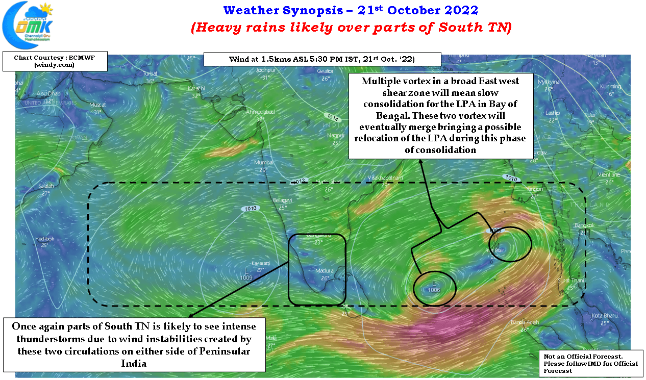
On the weather front the LPA embedded in a broad area of disturbance with multiple vortex has created a nightmare for weather models. Not only the broad circulation has made it tough for the LPA to consolidate the competing vortex scenario has made it more tough resulting in the initial schedule of this disturbance thrown out of the window. A week or so back most models expected this disturbance to be closer to coast by this time, the reality is the LPA is still over Southeast bay struggling to consolidate. It might be another day or two before it consolidates into a depression and heads towards Central Bay.
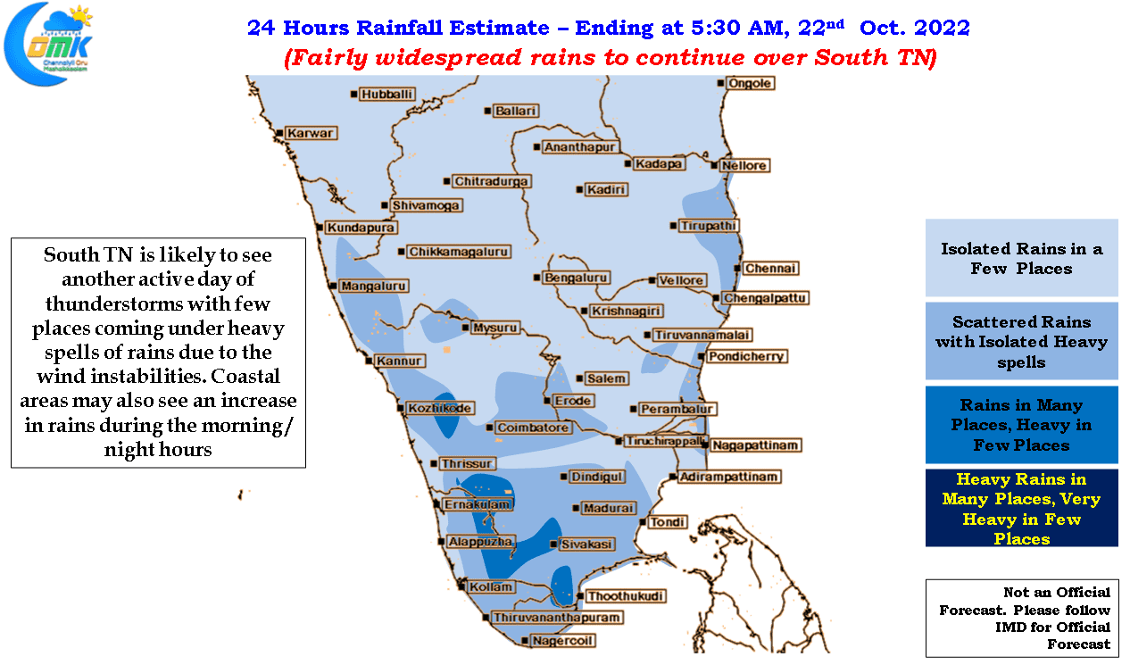
This period though is providing a window of opportunity for rains to continue over many parts of Tamil Nadu both in the form of early morning rains around coastal areas like Chennai and evening / night thunderstorms in the interior areas. Today once again fairly widespread rains may happen over South Tamil Nadu with few places coming under intense thunderstorm activity as wind instability created by the circulations on either sides of Peninsular India provide conducive conditions for South TN, parts of West interior TN and adjoining areas of Kerala.
Chennai and suburbs will possibly see rains continue during the night / morning hours until Sunday as things stand.