
Yesterday IMD confirmed the formation of Cyclone Phethai, the 4th Cyclone of the year in Bay of Bengal, and the 7th in the North Indian Ocean Basin including three that formed in Arabian Sea. After staying in the low latitudes for more than 3 days finally the disturbance started to show progress climbing up the latitude in a North/Northwestward movement.
With this N/NW movement it is time to accept COMK got it wrong with our estimates in terms of where Cyclone Phethai could head towards landfall. For nearly 3 days it stayed close to the COMK track estimated on Wednesday and possibly could have stayed further if the disturbance had continued its W/NW journey for another 6 – 9 hours or so. We will take this hit on our chin and learn from the experiences which will stay with us through our weather blogging life time.
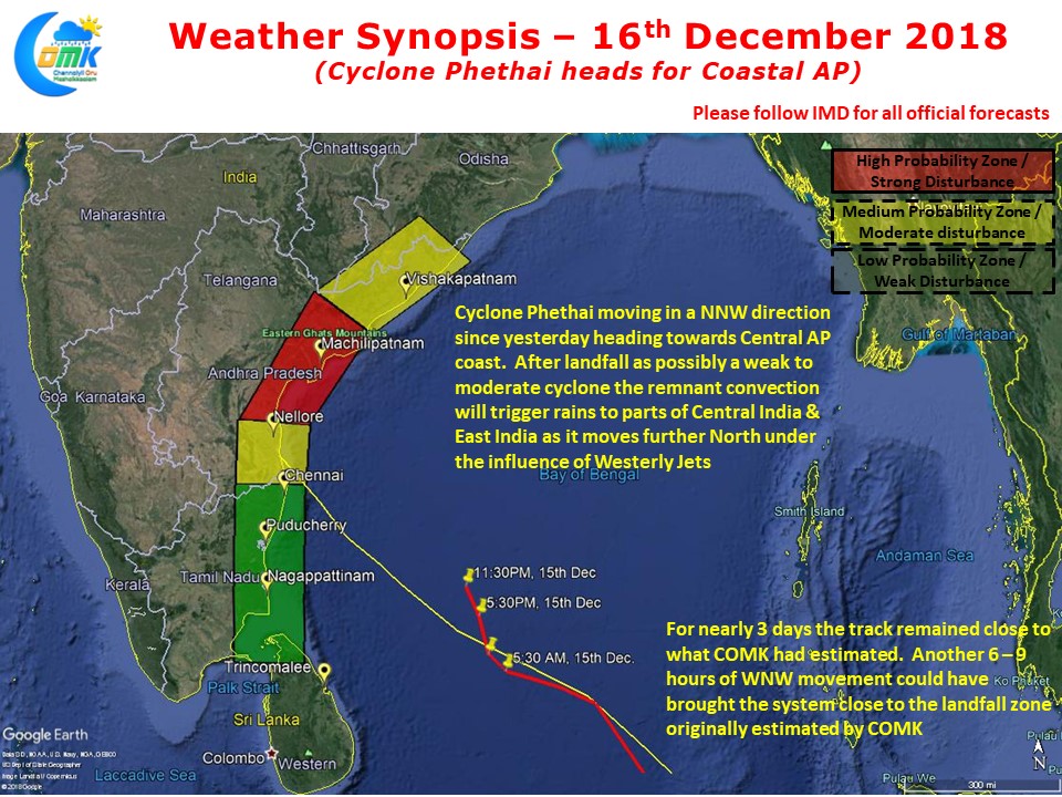
As things stand Cyclone Phethai now heads to Central AP coast making landfall as a moderate cyclone though it will reach up to Severe Cyclone status in the intervening period. Post landfall the remnant convection from the cyclone will get absorbed by the Westerly Jets bring moderate to heavy rains to parts of Central India & East India. Coastal AP is likely to see heavy to very heavy rains starting from tonight until landfall sometime tomorrow afternoon.
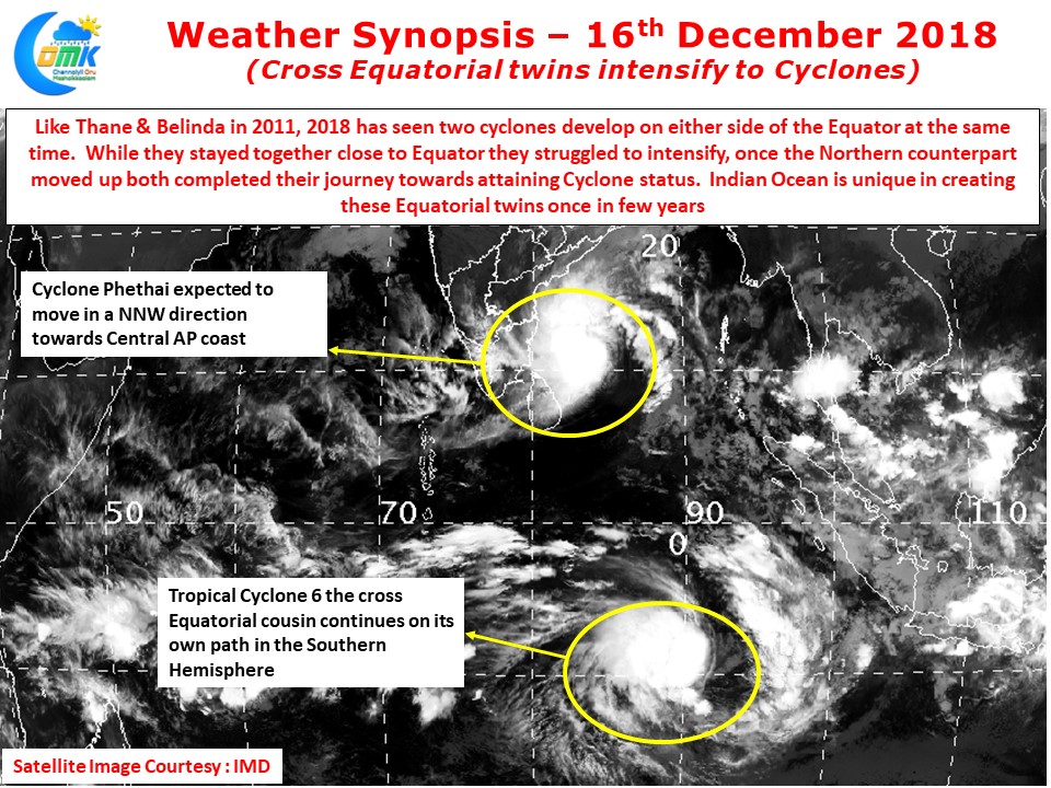
Interestingly just like Cyclone Phethai its cross equatorial twin almost mirroring the life cycle of its Northern Hemisphere twin becoming Tropical Cyclone 6. A look at the satellite image also indicate how very similar these two disturbances look in appearances too. In 2011 Thane & Belinda formed under similar circumstances as well. Indian Ocean is unique in this aspect which possibly no other basin can show regularly. The presence of large land masses in Indian Sub Continent and Australia on either side possibly plays a role unlike Atlantic or Pacific which are large expanses of water alone towards the south of equator.
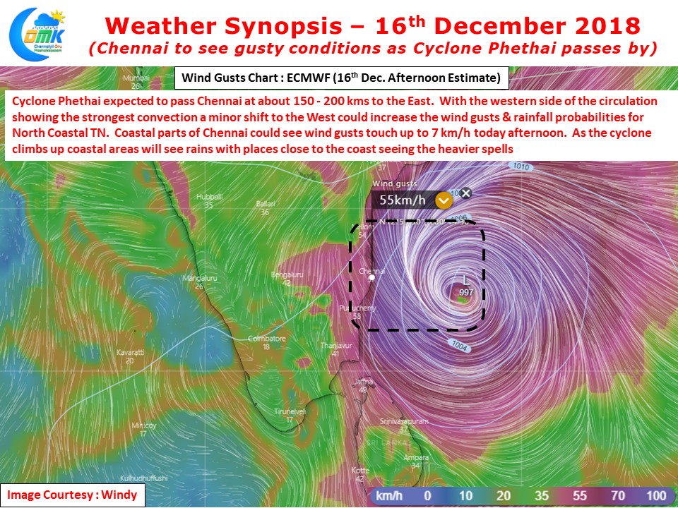
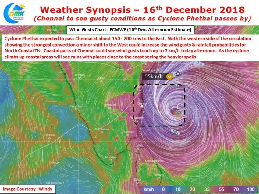
While Cyclone Phethai may not have come close enough to Chennai as estimated by COMK it will possibly brush the coast of Chennai at about 150 – 200 kms distance while moving towards Coastal AP. With the western side of the circulation appearing to be the most intensive any minor wobble or shift in the track towards the West could bring parts of Coastal TN under direct influence the system. Wind gusts over coastal areas including Chennai is likely to be around 50 – 70 km/h. As the cyclone passes by from SE of Chennai to NNE of Chennai spells of rains will continue until tomorrow morning possibly with heavier spells likely closer to the coast.
We take this opportunity to thank all those well wishers who stood by us since Wednesday despite being in direct contrast to global models. Our heartfelt apologies for getting this Cyclone Phethai estimate wrong. We are pluviophiles by heart may be that clouded our vision in what is turning out to be one disaster Monsoon year for Chennai