
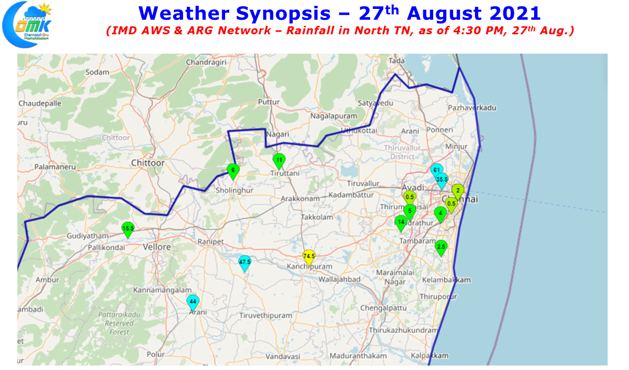
Midnight Thunderstorms once again checked in around Chennai & suburbs last night as many parts of the city recorded moderate to heavy spell of rains. The IMD ARG at Puzhal recorded 61 mm while the one at Villivakkam recorded 35.5 mm. To the Southwest of Chennai, Kanchipuram AWS recorded 74.5 mm rains while dead west to Kanchipuram the IMD AWS at Ranipet recorded 47.5 mm. Similarly Arani recorded nearly 8 cms of rains from the evening thunderstorms. Yesterday was the start of the spell of active thunderstorms for Tamil Nadu which is likely to continue during the weekend with weather models indicating perfect conditions.
With increased moisture availability over the west coast due to a developing circulation over Bay of Bengal there is a likelihood of a temporary slowdown phase of swinging pendulum between East & West coast giving a pseudo stationary moment for the Monsoon Pendulum to give rains to both the coasts of Peninsular India particularly south of 15N latitude. It is pertinent to add here though the monsoon dynamics is improving on the back of the developing low pressure area the westerlies are just about strong enough to play a constructive role for thunderstorm development rather than destructive role.

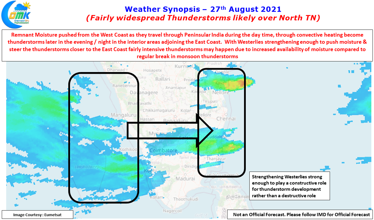

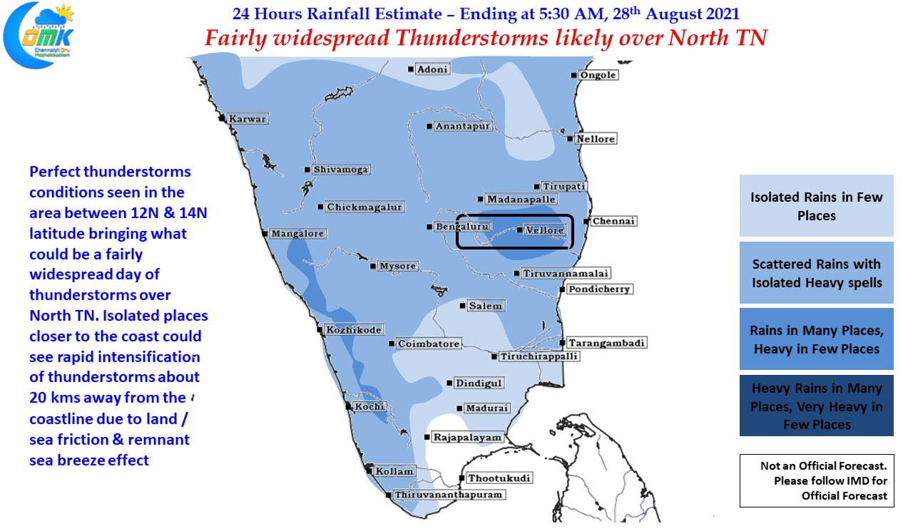
The master layer which acts as the bridge between Lower Troposphere & Upper Troposphere, 500 hPa at 5.5 Kms ASL altitude, is seen with a LWD like conditions over Peninsular India between 12N & 14N latitude created by the elongated circulation over the Bay of Bengal. This instability is likely to create conducive conditions for the remnant moisture from the West migrating across Peninsular India & going through its own convective development through day time heating intensify into mature thunderstorms as they reach about 150 to 200 odd kms to the West of East coast in the interior parts of Rayalaseema, Karnataka & TN.
All in all the next couple of days with the West Coast working as the background engine for the moisture to be pushed across Peninsular Coast & the Mid Tropospheric wind instability likely to act as the conduit for thunderstorms to intensify Tamil Nadu is likely to see fairly widespread thunderstorms until Sunday possibly before the monsoon starts picking up to the benefit of west coast. With some luck coastal areas like Chennai could see sudden rapid intensification of thunderstorms about 20 / 25 kms from the coastline due to land / sea friction bringing heavy spell of rains as the storms slow down & Cross coast.