
Over the past few years Monsoon, be it Southwest Monsoon or Northeast Monsoon, has been punctuated by longer dry spells interspersed with extreme rainfall episodes which while balancing the statistical averages ends up creating more harm than good through floods, landslides and associated damages. With the Indian Ocean being one of the warmest ocean bodies in earth more and more studies confirm of a change in the characterestics of the Indian Monsoon. While the number of moderate rainy days seem to be declining the number of extreme rainfall episodes is seen increasing putting a large part of the population in the Indian Sub Continent to not only Flooding and associated risk but also affect the Food Security due to risks created by erratic monsoon episodes in a country where more than 60% of the Area under cultivation is rain fed and almost half of the food grain production of the country comes out of rain fed areas.
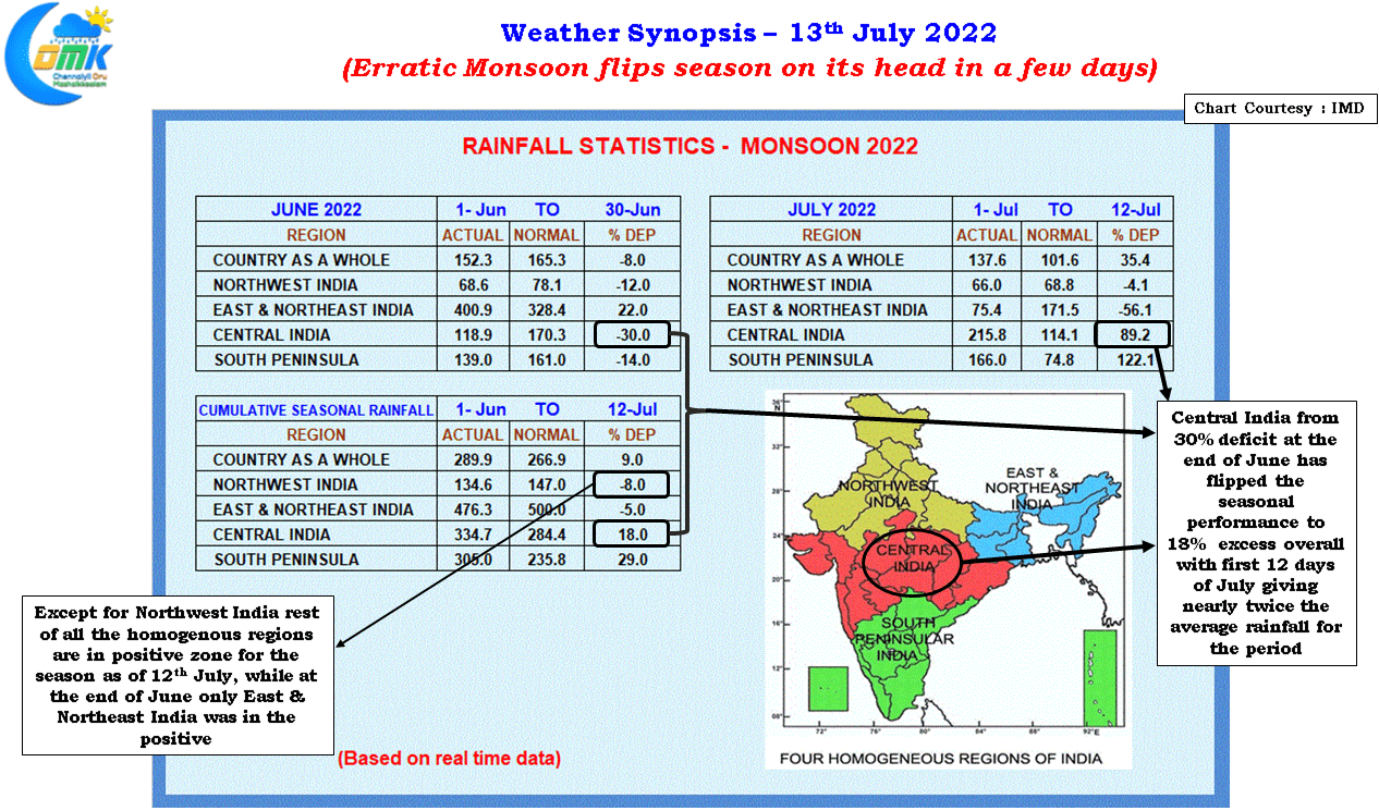
Enough has been written about how Southwest Monsoon was sub par for most of June with the country rainfall status settling at 8% deficit at the end of June. In another instance of extreme rains flipping the season on its head the last few days of extreme rains over parts of Central India and heavy rains along the Peninsular West Coast has turned the tables around with the seasonal rainfall average now standing at 9% excess of long period average as of 12th July. From -8% to 9% in a matter of two weeks. During this period Southern Peninsula received more than twice the long term average while Central India received nearly twice the normal rains.
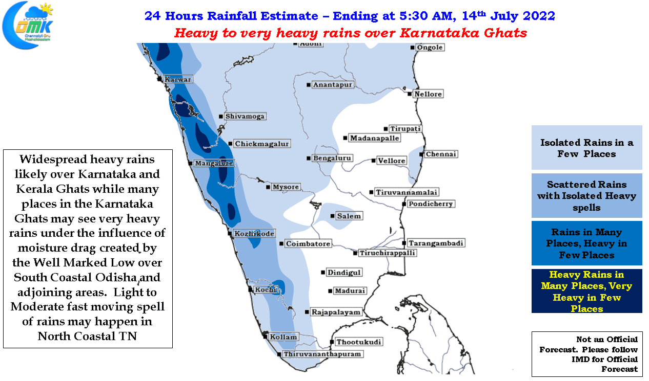
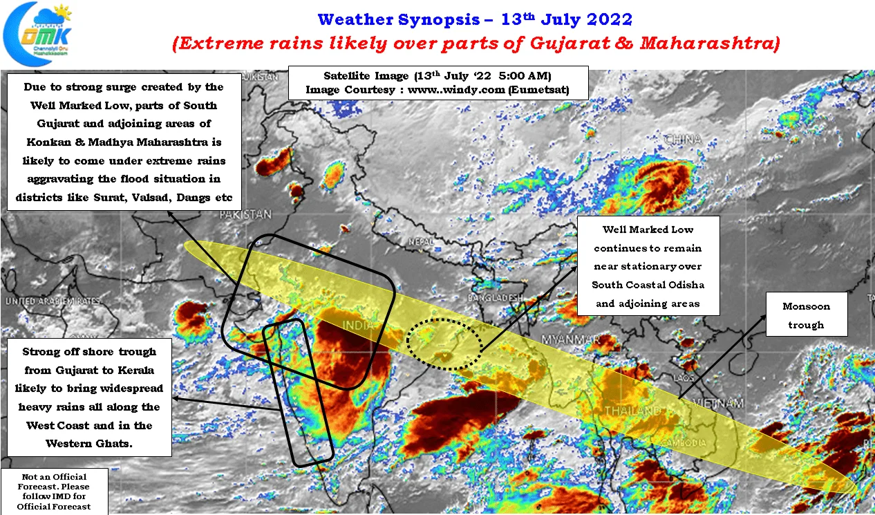
Many places in Southern Gujarat has been reeling under floods from extreme rains which saw places record as high as 50 cms in 24 hours period. With the Monsoon trough staying south of its normal position for the past few days and the Low Pressure off the coast of Odisha becoming well marked and staying at an almost stationary position the same areas continue to get battered by rains under the effect of the powerful monsoon surge created by the Well Marked Low. While yesterday saw some reduction in rains over Gujarat from today oncea gain places in Madhya Maharashtra and South Gujarat may come under heavy to very heavy rains bringing more trouble to the region.
While normally the leeward areas of Tamil Nadu including Chennai remains mostly dry during active monsoon conditions the powerful surge is strong enough to push remnant moisture to the East Coast of Peninsular India bringing pretty much daily rains over some parts of Coastal TN, particularly North TN, due to the wind pattern which seem to be the same every day influenced by the near stationary position of the Low Pressure off Odisha. Despite models not showing much rainfall activity for Chennai and suburbs until the Well Marked Low makes a move in reality the evening rains for Chennai and suburbs may continue through the fast zipping storms that cross the coast in lightning speed due to the powerful Westerlies.