
After a small lull in the rains last ni ght saw NEM2019 picking up once again as Easterlies not only strengthened but also streamlined across most parts of Coastal Tamil Nadu. Yesterday afternoon saw thunderstorms develop about 50 – 75 kms inland of the coastal line. These thunderstorms started to move from East to West indicating the strengthening of Easterlies. Later in the night many places in the coastal areas started to receive sharp spell of showers as is the usual pattern with Northeast Monsoon. Though many parts of Chennai did not record good rains the IMD observatory at Chennai AP recorded more than 3 cms rains as of 5:30 AM today morning.

Today early morning has seen parts of Delta has started seeing moderate to heavy rains in many places as rain bands start pushing in from ENE direction. For the next 24 hours few places in South TN and parts of Delta districts could see heavy rains while places like Chennai could see on and off spells of rains which will increase in intensity later in the night bringing heavy spells in one or two areas.

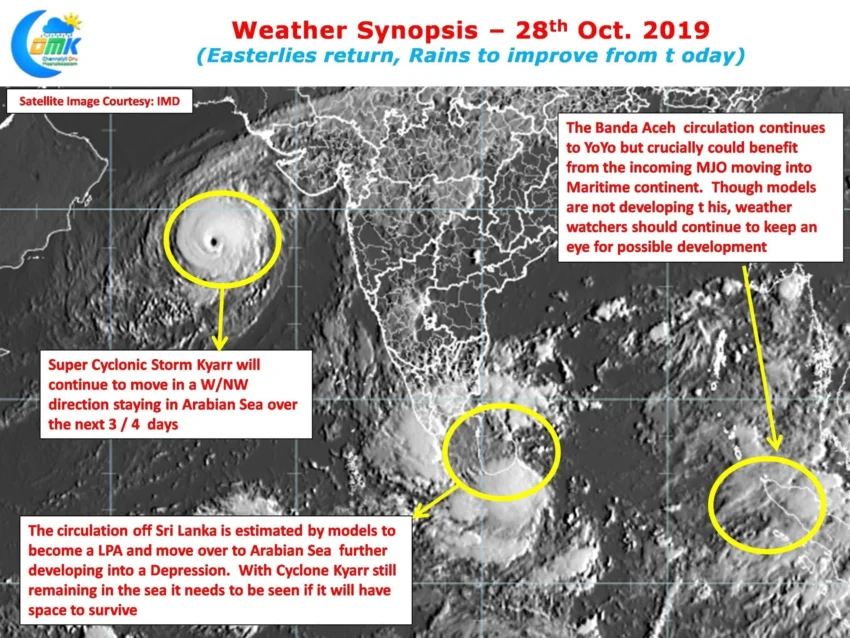
Over the Arabian Sea Super Cyclonic Storm Kyarr has intensified into the strongest Cyclone over Arabian Sea reaching a Central Pressure of 915 hPa which is lower than Cyclone Gonu in 2007 which reached 920 hPa at its lowest. Sporting wonderful annular features Cyclone Kyarr has remained very compact right through its life cycle so far. Cyclone Kyarr may continue to linger in the Arabian Sea over the next 3 / 4 days. Could this work as a blessing in disguise for NEM 2019
At Bay it is a heartening sight to see clouds rush into Coastal Tamil Nadu once again influenced by the Trough of Low currently persissting off the coast of Sri Lanka. Bay continues to see two distinct area of disturbances playing a battle of wits in the process going through a YoYo mode of strengthening & weakening. Numerical Weather Models continue to develop the circulation off Sri Lanka estimating it to become a Low Pressure within the next 24 hours making a slow jog in a westward direction towards Arabian Sea.

In this context it is imperative to keep in mind the following two factors
- Cyclone Kyarr will continue to remain a very strong Cyclone in Arabian Sea for the next 3 / 4 days before losing intensity & shape. It remains to be seen if the Circulation off Sri Lanka can move into Arabian Sea & get enough energy with Cyclone Kyarr still around in a closed basin like Arabian Sea which is not vast like West Pacific to allow multiple disturbances
- MJO which has been moving West to East is expected to influence the Eastern Indian Ocean and associated areas of Maritime Continent in a couple of days time. The possibility of the pulse near Banda Aceh benefitting from incoming MJO cannot be ruled out.
All in all its going to be a good time to be a weather blogger and watch the events play through the interplay of three different circulations across North Indian Ocean and a Tropical Wave added to the mix.