
Deepavali and Northeast monsoon share a very strong relationship over the Southeastern parts of Peninsular India. You ask anyone from a small kid to the elders almost all of them would have something to say about how rains and Deepavali is intrinsically linked. While for some rains on Deepavali day is a boon and for a few others, particularly the younger kids who would like to enjoy the fesitival with some crackers, it is a bane with rains playing a spoilsport in the festivities. But beyond this relationship of rains and Deepavali there exists a slightly larger context. How the Easterlies associated with Northeast monsoon often has been the savior for coastal places like Chennai.
Some of you may wonder how the skies around Chennai and suburbs tend to show nice blue hues during the Northeast monsoon season while the same skies tend to become hazy during the Southwest monsoon period. The answer to this question lies in the seasonal wind regime which bring breeze from the sea and land during the two respective monsoons. Among the various influences Easterlies do is improving the air quality over places in Coastal Tamil Nadu like Chennai with pollutants getting dispersed much better compared to westerly wind regime. It is in this context the state of Easterly / Northeast Monsoon conditions during the Deepavali festival plays a crucial role on how nature decides to help clean up the air around places like Chennai.
If one were to look at the PM 2.5 levels at Chennai ( data taken from Central Pollution Control Board website for Alandur station) over the past few years one can clearly see a pattern on how the state of Northeast Monsoon has an important role in mitigating pollution levels over the city in the form of stronger wind speeds and crucially the presence of rains around Deepavalii. 2017 which saw the earliest Deepavali date between 2015 and 2021 was the year with the highest average PM 2.5 levels for the 72 hours around Deepavali (24 hours preceding, Deepavali day and 24 hours succeeding). The Northeast Monsoon onset happened nearly 10 days after Deepavali during 2017 which sort of made it tough with PM 2.5 levels peaking at 837.8 to give a context any level above is 150.5 is considered very unhealthy. A combination of weak winds from WNW and very little rainfall during the 72 hour period meant the pollutants just hung in there.
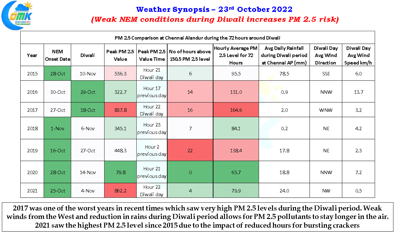

With Northeast Monsoon not making onset yet and the presence of developing Cyclone Sitrang in Bay of Bengal brings forward a combination of factors that might make it an unhealthy Deepavali this year for many. Weather models indicate not only dry weather to mostly prevail across the state on Deepavali day but also a drastic reduction in wind speeds, particularly over the coastal areas like Chennai, during the evening hours of Monday could make it a very unfavorable state for the pollutants to get dispersed quickly. Since 2021 there has been a key change in how crackers can be burst due to the Supreme Court ruling. With only 2 hours allowed for crackers to be burst on Deepavali day we are likely to see concentrated cracker bursting. 2021 Deepavali day in a way showed us the effect of this with the highest level of PM 2.5 seen since 2015. But the ban has certainly worked for the better with the average hour PM 2.5 level during the 72 hour Deepavali period and the number of hours when PM 2.5 level was higher than 150.5 being lower than most years except 2020.
Despite fairly good conditions 2021 saw PM 2.5 level peak at 862.2 with this year conditions expected to be very unfavorable in the form of dry weather and very weak winds (less than 10 km/h) Deepavali evening could turn out to be one of the worsts in recent years on account of the one hour cracker bursting window.
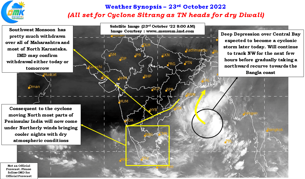
On the weather front IMD has confirmed the intensification of the Bay disturbance to a Deep Depression today and expect it to further intensify into Cyclonic Storm Sitrang later today. With a general NW track expected until later tonight the disturbance could intensity further into a Severe Cyclonic storm before taking a Northward recurve towards the Bangla coast early next week. Satellite image indicates Southwest Monsoon has pretty much withdrawn over most parts of the country and we could possibly see IMD announce complete withdrawal either today or twomorrow. This though may not mean onset of Northeast Monsoon on account of Cyclone Sitrang playing truant to the wind pattern
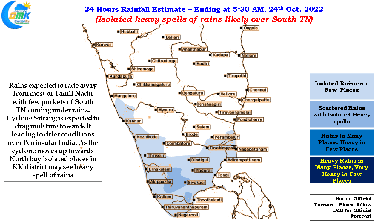
On the rainfall front mosts of North TN may see dry weather starting from today while parts of South TN may see moderate rains with isolated pockets particularly closer to the Ghats coming under heavy spell of rains at times during the evening hours. Tomorrow further reduction in rains may be possible as the Cyclone moves further North. With the arrival of continental winds from the North parts of North & Interior TN including Chennai may see cool evenings / nights bringing an early winter feeling for the next 3 / 4 days.
Wishing all our well wishers a Happy and Prosperous Deepavali on behalf of COMK.