
Southwest Monsoon is a weather event that stretches for nearly 120 days across the Indian Sub Continent. With such a long season every monsoon season goes through ebbs and flows characterized by active and break phases. While the break in monsoon period was known and tracked for more than a century by the Indian meteorologists. It was Dr. P Koteswaram, DGM of IMD between 1969 and 1975, who set the ball rolling in terms of developing a deeper understanding of these break in monsoon periods. Both Dr P Koteswaram and subsequently Dr. C Ramaswamy, DGM of IMD between 1965 and 1966, established a strong connect with the location of the Tropical Easterly Jet axis and active / break in monsoon periods. While one may say the monsoon powerhouse is the Mascarene High, it may not be wrong to say the strings of the monsoon puppet is actually held by the Tropical Easterly Jet and its intra seasonal movement over the Indian Sub Continent. In this context it is also essential to point some research indicate a long term weakening trend of the TEJ as Indian Ocean continues to warm up.
This year’s Southwest Monsoon season has just unrolled its first break in monsoon period. One may wonder with most of June seeing sub par rainfall why would the first break in monsoon period happen only now. Over the years as Southwest Monsoon went through intra seasonal ebbs and flows it became essential to formalize a clear protocol. One such exercise was undertaken by Dr Sulochana Gadgil, Dr M Rajeevan through their paper Active and break spells of the Indian summer monsoon. Subsequently IMD adopted a clear protocol for active and break in monsoon spells in the form of a standardized rainfall anomaly over the core monsoon region. Active and break events are defined as periods in which the normalized anomaly of the rainfall over the monsoon zone exceeds 1 or is less than -1.0 respectively, provided the criterion is satisfied for at least three consecutive days.
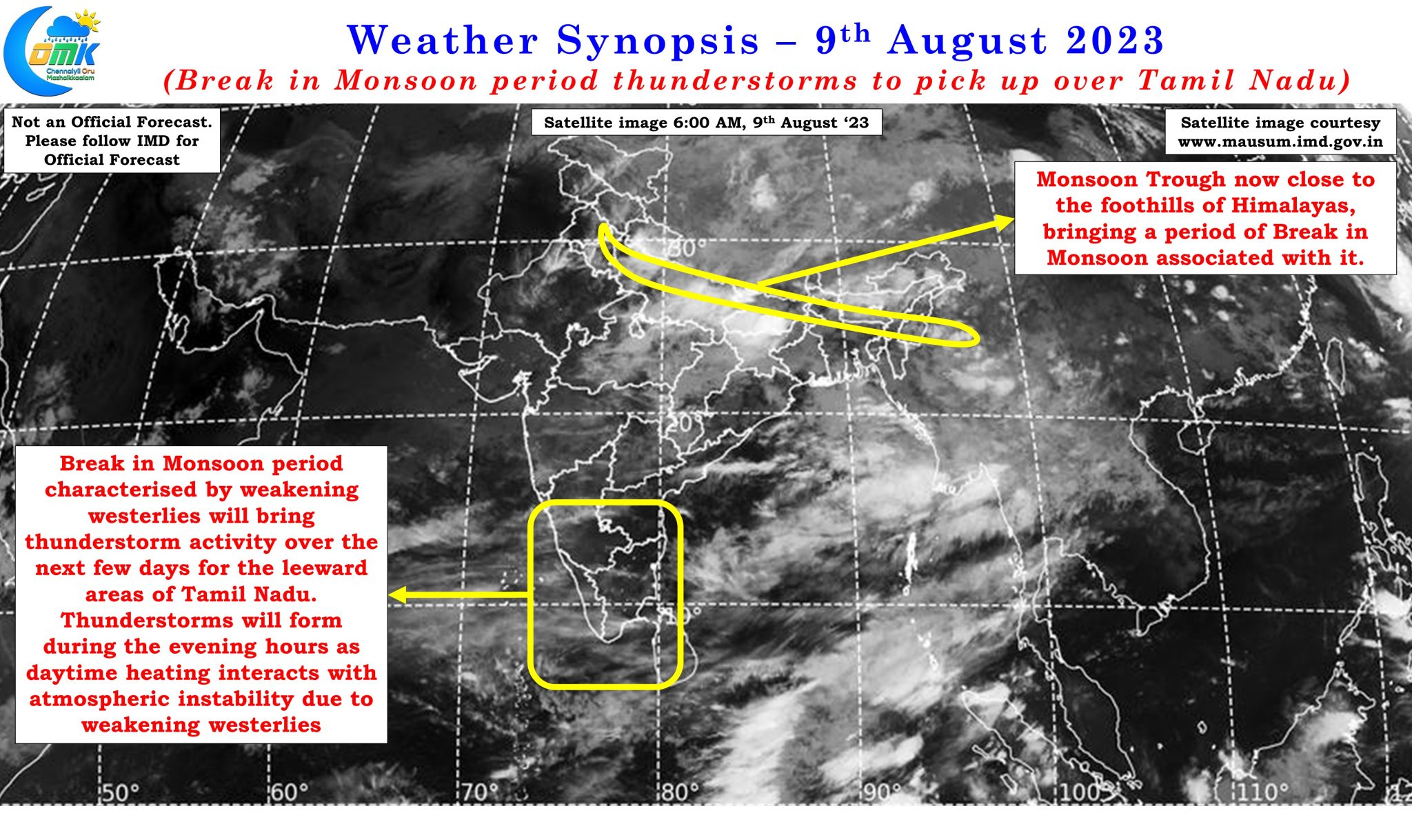

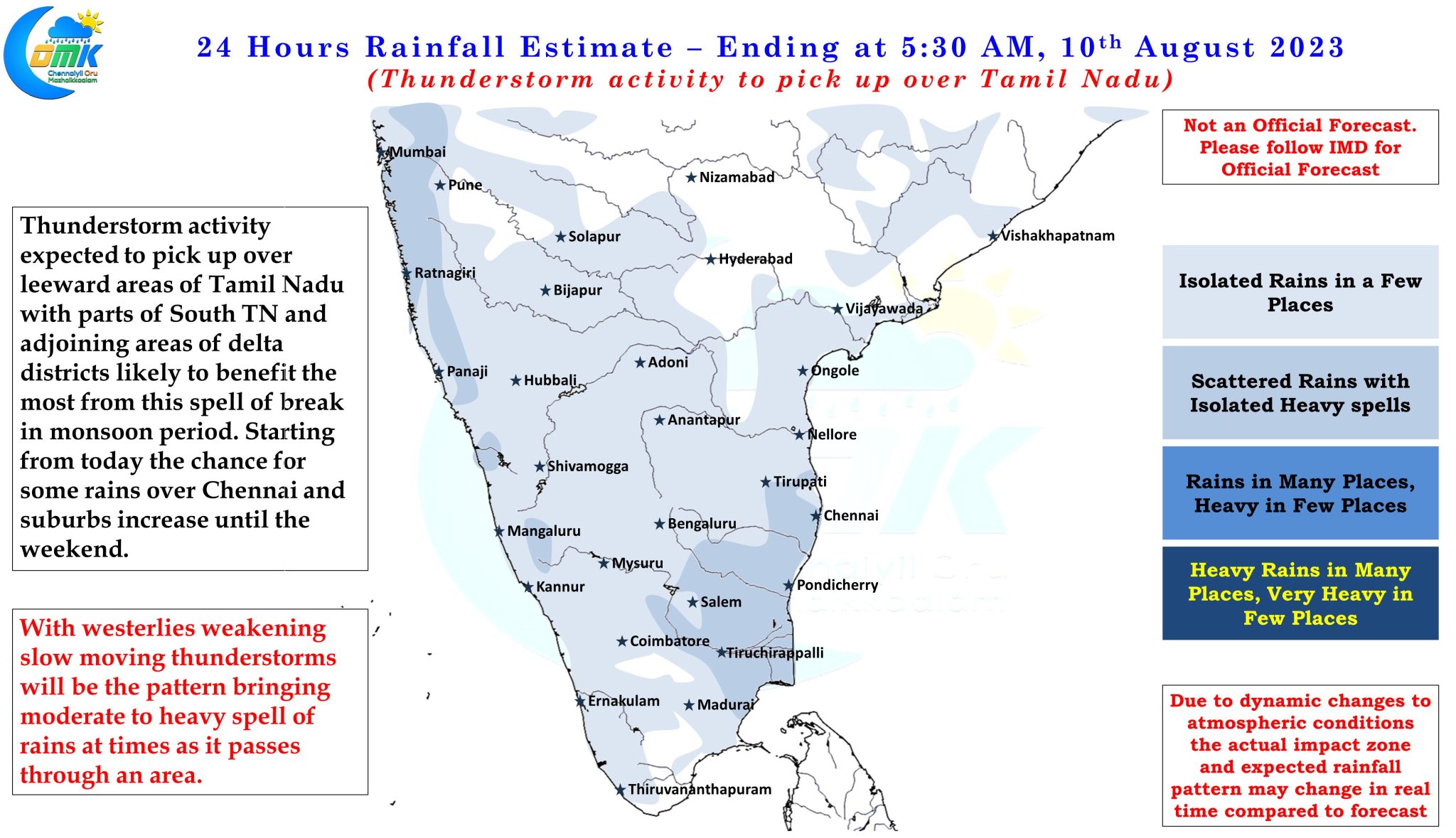
With break in monsoon period underway and expected to last for a few days it is good news for the leeward areas of Tamil Nadu which normally see increased thunderstorm activity when westerlies weaken over Peninsular India at this time. Over the next few days, possibly until the weekend there is an increasing consistency among weather models on the increased rainfall activity over places in Tamil Nadu. In a way yesterday’s fairly intense spell of rains around Kumbakonam and surrounding places of Delta is an indication of the pendulum swinging towards thunderstorms along the East coast from the monsoon rains over the West coast. With a weak Kelvin wave influence seen over the Equatorial waters there is a fair possibility over the next couple of days few places in South Tamil Nadu and adjoining areas of delta districts may see intense thunderstorms. Weak westerlies would also mean slow steering for the thunderstorms thereby resulting in heavier and more intense spell of rains for the places which come under the movement of thunderstorms.
While South TN and adjoining areas of delta district is expected to be the biggest beneficiary of this spell of thunderstorms until the weekend or possibly early next week, the possibility of sea breeze induced thunderstorms triggering a sudden burst of rains over the KTCC districts cannot be ruled out. As always the case with Veppasalanam rains the real time wind instability locations and steering of thunderstorms will ultimately decide the impact zone on a day to day basis.
Before we wind up the post clear skies during the early part of the day and afternoons is here to stay and will keep the day time temperatures above normal for most of the remaining days of August. The evening thunderstorms though could make the nights cooler though.